Saguaro
-
Posts
144 -
Joined
-
Last visited
Content Type
Profiles
Blogs
Forums
American Weather
Media Demo
Store
Gallery
Everything posted by Saguaro
-
Was that July 2011? Or was there another event in 2010, I can't remember very well. I wonder if WPC will ever put a dryline on the current sfc obs map in NE during these occurrences, since a couple months ago I remember there being a similar situation with a severe outbreak in Illinois, and they actually drew a dryline on the map in that one. It wasn't the usual desert origin dry air which is why I found it unusual.
-

May 2024 Discussion - Welcome to Severe Season!!!!
Saguaro replied to weatherwiz's topic in New England
Managed 93.2 this afternoon, slighty above IZG. It has been a cool year so far, first 90s were delayed to mid April (usually happens around the equinox), and just a couple days ago it finally hit 100 for the first time. -
May 2024 Discussion - Welcome to Severe Season!!!!
Saguaro replied to weatherwiz's topic in New England
Going to be close. We're in a cooler pattern the last few days, IZG hit 91.9 and our current high 91.4. I just thought the NNE heat was impressive for this time of year. -
May 2024 Discussion - Welcome to Severe Season!!!!
Saguaro replied to weatherwiz's topic in New England
IZG at 91, warmer than Phoenix metro currently (~89 here). -
Looks like most of Maine held off the gloom but it creeped into western ME towards late afternoon. There have been a copious amount of clouds here in AZ today as well, but still managed a high of 90. This is definitely the time of year when being in AZ vs the coastal plain of NNE pays handsomely.
-
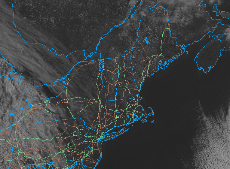
It's been a long week and I just now have gotten the time to write up my experience Monday. I was deciding between Colebrook, northern VT, or Eustis area. In the end given the satellite cloud trend, and to maximize totality time, I went for Third Connecticut Lake on the Quebec border. There were no clouds to speak of, not even cirrus, so viewing was perfect. Conditions in the area were still pretty set in Winter, with the lake frozen over thick enough that most people were out on it in chairs and had tripods set up. The snowcover was at least a foot deep if not more. The eclipse itself was magnificent, and it looked better overall that the 2017 one I saw in Idaho which was marred by a thin haze of forest fire smoke. The corona looked a lot larger this go around, and the large flare at the bottom stood out. I regret forgetting to look for shadow banding in the minute before and after totality. I imagine on the expansive snowcover of the lake, it would be very easy to notice. I'm wondering if anyone got video of it in that area. I do not have any decent camera gear so I was only able to manage a phone picture pre-totality and short video during. The drive back took at least twice as long as normal, about 5 hours, thanks to closures of alternate routes to US 3, and an enormous backup in Errol that took over an hour to get through. It was still worth seeing and I'm glad I was able to experience it. It's amazing the weather cooperated so well with the timing. Right after I went back to Arizona, the usual spring time perpetual gloom, cold, and dampness settled in to plague Maine for what looks like a long stay.
-
Yea I have hesitation about that area and there's only one major road there. I'm probably headed to Canaan/Colebrook/Pittsburg.
-
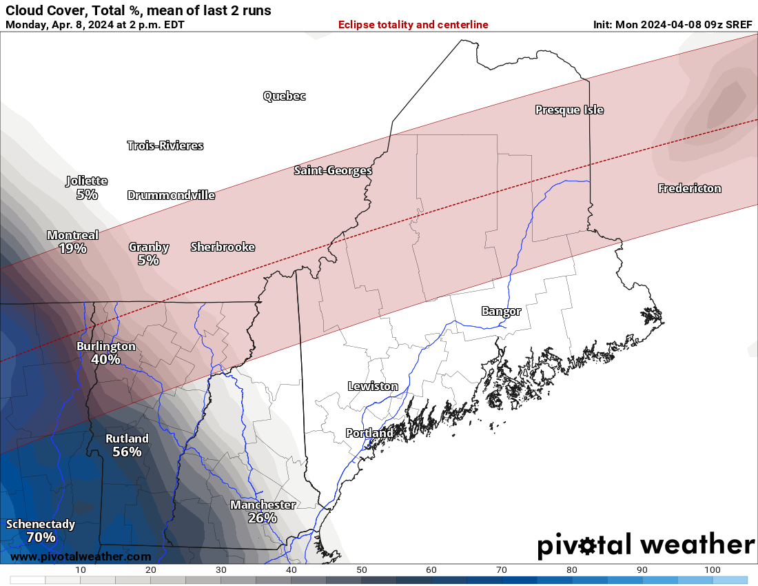
Unfortunately they only have that specific time. There does seem to be a bit of an E trend if you check the previous model run. https://www.pivotalweather.com/eclipse2024/?m=srefens&p=cloudcover_tle_2-mean&r=us_state_ne_n
-
High clouds creeping towards w VT. Hopefully they'll hold off.
-
Got into Portland from Phoenix late Saturday night. Original plans were for southern TX but I pulled the plug on those Thursday/Friday. The departing storm was still spitting out snow from around 7k feet all the way down to around 900ft in PWM area where it changed to rain showers the rest of the descent. A pretty big difference from the 70s and 80s we've been getting in AZ. The snowcover is melting rapidly, already down to patches, hard to believe 18" fell a few days ago. Starting from Harrison tomorrow morning and am thinking Norton, Canaan, Colebrook, Pittsburg or maybe Newport. Eustis to QC border area is a possibility too.
-
My original plans for Texas aren't looking good. Have backup plans for Maine, tip of NH or Quebec, will lose a minute of totality but that seems the best bet currently.
-
The Congrats Dendrite Deck Destroyer 3/23-3/25 obs discussion
Saguaro replied to Ginx snewx's topic in New England
IZG reported brief switch to sleet but it's back to snow now. Curious what things are like in Harrison and Bridgton, looks like their expected totals may be cut down by the sleet. -
I saw the 2017 one in Sawtooth National Forest in Idaho. It was spectacular with exception of being marred by forest fire haze. I'm planning on driving from Phoenix to southern Texas for this one, and getting an early start from San Angelo Monday morning. Hopefully the climatological sunshine % in that area comes to fruition.
-
Thursday, July 27, 2023 Severe Weather Potential
Saguaro replied to weatherwiz's topic in New England
The monsoon storms in AZ have been more impressive than anything I've seen here. Last July a complex ripped through from SE to NW with 80mph gusts, knocked the power out for 18 hours. Helps when it's over 100 degrees out ahead of the storm. -
Thursday, July 27, 2023 Severe Weather Potential
Saguaro replied to weatherwiz's topic in New England
Finally the first peeks of sun today behind that line as it moved off to the SE. -
Thursday, July 27, 2023 Severe Weather Potential
Saguaro replied to weatherwiz's topic in New England
Yea it's been solid overcast draw the shades mood all day. The line arrived here about ten minutes ago and the only thing noteworthy is torrential rain. No thunder or wind or anything like what's happening in NH and SNE. The only excitement I've seen in Harrison is the mini tornado outbreak back in July 2018. Multiple hits in Bridgton and one lifted as it crossed long lake moving into Harrison. -
Thursday, July 27, 2023 Severe Weather Potential
Saguaro replied to weatherwiz's topic in New England
It's pretty remarkable how consistent warm fronts are in dying on our doorstep. Even when it's not the low level crud, as today proves. -
July has arrived ... the Meteorologically defined mid summer month
Saguaro replied to Typhoon Tip's topic in New England
IZG with the ultra rare 73 dp at the moment. Today has been surprisingly soupy. -
Thursday, July 13 - Friday, July 14, 2023 Convection
Saguaro replied to weatherwiz's topic in New England
Anything south of Bethel ME has fizzled. Even those have no polygons so they must not be very impressive. -
July has arrived ... the Meteorologically defined mid summer month
Saguaro replied to Typhoon Tip's topic in New England
Looks like that cell collapsed pretty fast. After it moved through we finally broke out into the sun after being plagued with high overcast most of the day. I was in Naples and Rome last month and I noticed the same thing with the latitude vs weather. It was remarkable how consistently they were able to both get into and hold onto a solid summer airmass and not have it constantly assaulted by backdoors, unrelenting buzzsaw troughs, heat ridges getting cut in half, marine layers, cloud debris, et al. -
July has arrived ... the Meteorologically defined mid summer month
Saguaro replied to Typhoon Tip's topic in New England
Little cell blowing up in southern oxford and the fishtail of cumberland county, moving NNE. Hearing lots of thunder and some rain starting now. -
July has arrived ... the Meteorologically defined mid summer month
Saguaro replied to Typhoon Tip's topic in New England
cod satellite is broken today. Lots of clouds putting a damper on highs so mid 80s are going to be as warm as it gets. Yesterday was spectacular, a day earlier than I expected the marine sludge to get dislodged. Forecast looks terrible for any more sun before next Tuesday. -
July has arrived ... the Meteorologically defined mid summer month
Saguaro replied to Typhoon Tip's topic in New England
I think it's mostly a Maine thing. I can definitely feel a difference outside tonight versus the previous several evenings. IZG dp is 66, PWM 64, AUG 66. Getting a lot of marine intrusion, the whole of Androscoggin county was socked in with it all day under low overcast like a May gray or June gloom day in the LA basin. The high is far enough offshore that we're having to deal with these issues now. We probably won't clear out until Wednesday. -
July has arrived ... the Meteorologically defined mid summer month
Saguaro replied to Typhoon Tip's topic in New England
This marine taint has knocked dewpoints down to mid 60s