George001
-
Posts
6,140 -
Joined
-
Last visited
Content Type
Profiles
Blogs
Forums
American Weather
Media Demo
Store
Gallery
Everything posted by George001
-
It is? I thought the trough out west was bad. Even Metfan starts to panic when he sees a trough in the west. When Metfan is panicking that’s usually not a good sign, as like me and James (rip) he has snow goggles and tends to be too aggressive with his forecasts. My concern is that with the trough in the west and the strong pacific jet that the pattern would be really zonal, with ceiling being a 6-12 inch storm if everything lines up. I am looking for a severe winter with at least 3-4 massive blizzards like 2010-2011, 2014-2015, ect.
-
Hopefully the strength of the La Niña continues to increase. The entire Pacific Ocean is too warm and we need a decent strength nina to cool it off, limiting the pacific Jets ability to strengthen. The good news is that in the most recent update of the cfsv2 model, there is much less spread than even just a couple weeks ago. This indicates that the picture of what the Enso state will look like in the winter is becoming more clear, with the cluster being narrowed from -.5 to -1.8/-2.0 to -.8 to -1.3, with the mean being right -1.1, a low end moderate. The subsurface also indicates that the structure of the la nina could shift from a western based Nina to a basin wide or even a more eastern based la nina. A high end weak or low end moderate basin wide or east based La Niña would be very favorable for New England blizzards, so hopefully the models are right about that.
-
Yikes that’s not a good look. That ridge in the northern Pacific Ocean is way too far west. It does look like there is a signal for a polar vortex event, but with the polar vortex intrusion being west like last year. North Atlantic blocking is also limited, which combined with the awful pacific would be a disaster.
-
I do think there will be a La Niña but I agree that the pacific won’t be all that great this winter. There is too much warmth in the Pacific Ocean right now, and I don’t see that going away completely this winter. However I don’t think it will be anywhere near as bad as last winter, and in my opinion we will likely have severe North Atlantic blocking as well as several polar vortex intrusions. In New England we are probably good for at least 3-4 severe blizzards this winter, unlike last winter where we only had one (2 in most areas, that early feb one I got skunked, only 8-9 inches while 15-20 miles NW got 18+ inches).
-
Right now my call is -1.6 ONI peak for this La Niña. I am very confident that there will be a La Niña, less so of the strength. My current thoughts are: Super La Niña: 14% strong La Niña: 35% moderate La Niña: 30% weak La Niña: 20% cool neutral: <1% warm neutral: 0% Weak el nino: 0% moderate El Niño: 0% strong El Niño: 0% super El Niño: 0% What would your guys predictions look like in terms of percentages and ONI peak? For mine one thing to note is I wouldn’t say anything is completely 0, but the odds that we get an El Niño this winter in my opinion are lower than the odds of me getting struck and killed by a giant meteor tomorrow.
-
Yeah I was not aware of the cdc using a different baseline than the models, that explains why the models appear to underestimate the strength of la ninas. I see what’s going on now, the models aren’t actually underestimating the strength of la ninas consistently, just using a different baseline.
-
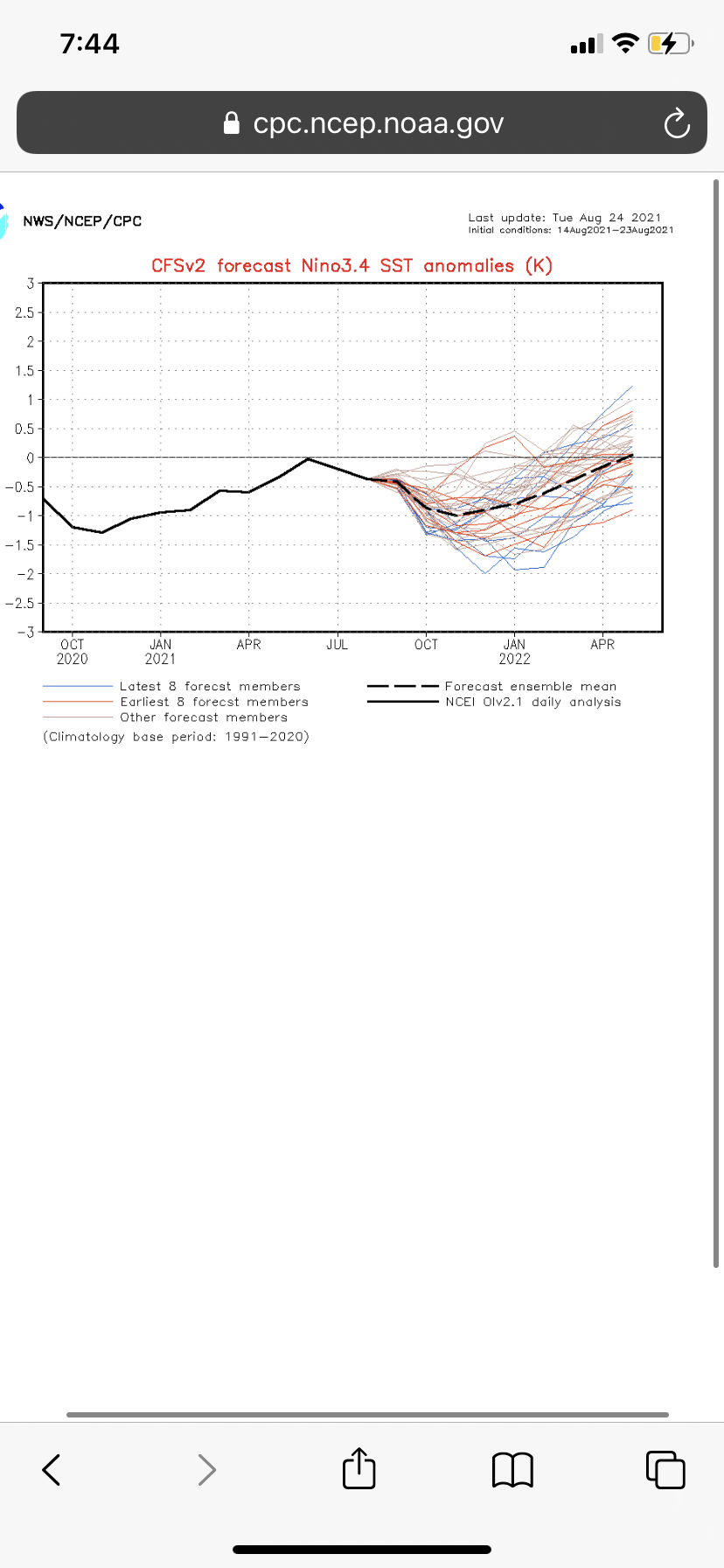
I am leaning towards a moderate or strong La Niña but this is definitely something to consider. The models have underestimated the strength of la ninas historically, if on average they underestimated the strength of the La Niña by .25 then taking that into account that puts us right at -.8, which is the strength of the 2017-2018 weak La Niña winter. For me, I have been keeping track of the cfsv2 model and paying attention to the trend as well as what the forecast is. Looks like it’s expecting the Nina to peak in the fall at -.1, right on the border of weak/moderate. However, the spread is still very wide, from .5 to -2, with most of the members being -.5 and -1.5. However, there are more outliers in the -2 range than the .5 range, and even more telling is that all of the blue line outliers are towards the lower end of the envelope. This suggests to me that even though a -.8 to -.9 is the forecast right now, if this ends up busting, it’s likely going to be busting warm. 7/8 of the most recent forecast members take the La Niña to -1 or below, solidly moderate. What really tilts this in favor of a stronger Nina for me is that this update of the cfsv2 model is that the members haven’t even ran yet after the drastic drop in temps from -.4 to -.9. Once it does, I wouldn’t be surprised to see the mean drop from -1 to -1.2 to -1.3, possibly even lower.

-
Over the past week, the strength of the La Niña has drastically increased. After the development of La Niña stalled out for a bit, we have more than made up for that lost ground with the Enso 3.4 region dropping from -.4 to -.9 degrees Celsius, which is already borderline moderate La Niña conditions. To put this into perspective, right now the enso 3.4 region is cooler than the last CFSv2 runs mean peak for the entire winter, which was -.8. Another thing to note is that if you look at the blue members, which are the most recent forecast members, all of them are below the mean of -.8. This suggests that the strength of the La Niña is being underestimated by quite a bit on the models. At this point, the question isn’t whether or not we get cold neutral or weak La Niña, but whether we get a weak-borderline moderate La Niña at -.8 to -.9 and it stalls out (possible if the subsurface doesn’t keep cooling off, it has stalled in recent weeks), or it keeps strengthening and we get a 2010-2011 redux (-1.6 peak, -2.4 MEI. Extremely strong La Niña).
-
True, It doesn’t mean good winter at all, but it increases the chances of North Atlantic blocking in my opinion. The issue is the entire pacific is just too warm, which fuels the pacific jet to strengthen rapidly. We have had North Atlantic blocking and had bad winters anyways several times. Sometimes blocking can be bad too if you have a moderate or stronger El Niño, then everything misses to the south like 2009-2010 (in general). I would rather see signs favorable for blocking with a La Niña coming up than an El Niño. In 2014-2015 if I remember correctly the solar activity was high, and we had little to no North Atlantic blocking that winter. Yet that was the snowiest winter on record in southern New England.
-
-.9 already? WOW. That is already borderline moderate strength and summer hasn’t even ended yet. It looked like the La Niña was slowing down for a couple of weeks but we made up that lost ground fast. 2010 sticks out like a sore thumb when looking at the similar ONI and SOI readings by late August. When looking at both the ONI and SOI and comparing similar readings, more strong la ninas show up than weak ones.
-
In 2010-2011 the solar was on the lower side but on the rise like this year, and the geomagnetic activity was very low. This winter will be similar in that area but you bring up a good point about the Enso state of the previous winter. The enso state the previous winter in 2010 was strong El Niño, the previous enso state last year was moderate La Niña. That is the exact opposite which is not ideal for an analog. I have read on Isotherms blog, in the forecast for the 2010-2011 winter he mentioned the geomagnetic activity has a much stronger correlation with North Atlantic blocking than the QBO (Isotherm, if I misinterpreted or misunderstood what you wrote, feel free to correct this). I thought the QBO was more correlated with the polar vortex than north atlantic blocking, with positive QBO being correlated to lower chances of a severe polar vortex event. My understanding of the QBO and polar vortex is low so that may be an oversimplification, but that is what I got out of the reading I did on it.
-
The low is not going to go out to sea. It is moving due north right now, if it were going out to sea you would already see signs of the low slipping to the east, but that isn’t happening. An eye is forming which suggests the strength of the low is also increasing.
-
It’s definitely not good with the blob of warmth in the pacific right off the west coast being too far west. I don’t like seeing that, but at least the rest of the pacific is more mixed of warm and cool anomalies rather than the entire thing being on fire like last year (other than the Enzo region). Correct me if I’m wrong, but wasn’t last years even worse? If I had to give it a rating on a 1-10 with 1 being terrible and 10 being great, I would give last years a 1.5, this years pacific a 4, and 2010-2011 a 9. How would you rate the pacific sst in terms of how favorable it is for winter in those 3 years?
-
Wasnt 2010-2011 strong Nina not moderate? The oni peaked at -1.6, which is strong. The MEI peaked at -2.4 in the fall, going by that the 2010-2011 is a super Nina. Either way when taking both ONI and MEI into account it was a strong La Niña that was dominating the pattern for the entire winter.
-
I already told my family there is going to be a massive hurricane headed for us. With a storm like this id rather be overprepared than underprepared. I noticed that some posters here aren’t really taking the storm that seriously, which I kinda get because the low doesn’t look all that strong on the models. If anyone is planning on going on like normal with their plans tomorrow, I strongly recommend reconsidering, even if it’s unlikely you do not want to get stuck driving home in the middle of a stronger than expected category 2 hurricane. I am aware that is not the forecast right now, but with how the storm looks right now the possibly that it strengthens more than expected is there. I hope it doesn’t get that strong because I’m not a big fan of hurricanes like I am blizzards, but I just can’t see how this ends up being weaker than expected looking at the storm right now.
-
That looks extremely powerful. When you see an eye like that it’s a sign that the low is going to strengthen more than expected. I have never in my life seen a storm with an eye end up being weaker than expected. In my opinion the models will start increasing the strength of the low.
-
I haven’t noticed any east trend at all. On the euro, navy, and short range guidance like the nam, rgem, href ect the low makes landfall around eastern long island, comes up right over Rhode Island and then moves west into the Berkshires and right over the Hudson Valley. This storm will be extremely powerful, blowing it off is a big mistake in my opinion, with how far west the low is moving we could see tropical storm conditions as far west as Albany. The low has actually moved west since yesterday, before they were saying it was going right over eastern mass and now it’s going over western mass.
-
The models are looking weaker with the winds than they were yesterday due to a decrease in the strength of the low. This will still be a severe tropical storm, but maybe with 70-80 mph winds instead of 90-100 mph.
-
Definitely something to watch, and is going to be a reason why how this winter plays out in my opinion will be determined by how much North Atlantic blocking we get. In 2015, we had little to no North Atlantic blocking, but had a west based El Niño, so the dominant storm track was farther south. This year we will likely have a west based La Niña like 2010-2011, which is a year that we did have severe North Atlantic blocking. The next year had no blocking whatsoever with again a west based Nina, and that winter sucked. I have noticed that the recent trends in the Enso region have moved away from my idea of a strong La Niña. Although it appears like your idea is going to correct about a weaker strength La Niña, what do you think about 2010-2011 analog? I was thinking it could still have some merit if the ONI of this La Niña can sneak into moderate territory due to the west based nature of the La Niña, stronger mei as well as other similar drivers like the increasing solar activity.
-
This is going to be the second tropical storm or stronger to hit the New England region this year and we still have a long way to go before the end of hurricane season. In my opinion, this year will go down as one of the most severe hurricane seasons on record.
-
The low is headed right over my backyard. This storm is terrifying, the extreme wind being forecasted in my area remind me of Irene. That was the worst storm I have ever experienced in my lifetime, the wind was so extreme that the trampoline was blown off the ground and started bouncing around my backyard. We lost power for a week, with fallen trees and branches everywhere. My area only got like 2-3 inches of rain, but the extreme wind is what made that storm so devastating in my area.
-
I just looked at the models and it looks like they are taking the low just to the west of my area. Should I start preparing to lose power? I live in the middle of the woods so in big storms I often lose power.
-
I 4 and 5 put sometimes, my putting definitely needs work.
-
I’ll try #3 that seems like a good tip, something I struggle with is I try to sell out for power and hit the ball as hard as I can. When I do that the ball ends up only dribbling a 10-20 yards or it goes far, but in the woods. I have been trying to increase my distance on my swings because right now my 9 iron goes 130, 7 140, 5 150, ect which isn’t that far. I’ve been experimenting with my swing some to try and find something that will help me hit it farther, but haven’t had much luck yet. I feel like I would be better off just trying to get the basics down and hit the ball straight, in the air, and just make solid contact. I do eventually want to increase my distance but without sacrificing my form, would a better idea for that to go to the gym and start building some muscle, while on the course just focusing on technique and consistency?
-
A good way to lower your score is to take a lot of mulligans. That’s what I did the other day, I kept hitting it in the woods and one one hole i took like 4 or 5 mulligans and was able to get a triple bogey instead of a snowman.