George001
-
Posts
6,972 -
Joined
-
Last visited
Content Type
Profiles
Blogs
Forums
American Weather
Media Demo
Store
Gallery
Everything posted by George001
-
Looks like snow ratios were big in this storm, the QPF total was what the higher end of what guidance had (like eduggs said above) but the ratios were like 20:1 instead of 10:1, so those 10:1 snow maps ended up being an epic fail.
-
I don’t know if it means anything now, but the La Niña trending towards being more and more east based could be really good for later in the winter. The pattern looks to be really good for the rest of Jan on the long range models, could the East based nature of the Nina help us in Feb and March?
-
I’m eyeballing 12-13 inches, what a storm!
-
The latest hrrr has about 4-6 more inches of 10:1 ratio snow in eastern mass (in the heavy bands there are reports of 20:1+ ratios) it started running this hour, so that’s on top of what has already fallen. The funny thing is, the QPF output is actually HIGHER now than it was for the entire storm on some of the weaker runs last night.
-
Thanks lol I’m already at around 10 inches and it’s still puking snow. What a storm!
-
My forecast might have been too conservative for once
-
He gonna wake up a very happy weenie like I did.
-
I’m eyeballing 6-7 inches…. holy shit
-
The latest hrrr has .6-.7 more QPF for eastern mass, that’s on top of the snow that has already fallen. Ratios have reportedly been as high as 15:1 or 20:1, so extrapolating that for my area we would have 9-14 more inches on top of the 4 or so inches we already had (last I checked). That would result in a 13-18 inch storm total if correct.
-
Did the strength of the low increase more than expected?
-
Foxborough area
-
Holy shit
-
The HRRR runs that only gave my area 4-5 inches of snow last night are going to be WRONG! I’m getting BURIED!!! Gotta be at least 3-4 inches already and massive flakes. The TV mets were saying when we wake up at sunrise there wouldn’t be a ton of snow on the ground. Am I going to get over a foot?
-
Thats very interesting how there were three lows earlier and now there are only 2, looks like one of the lows to the east absorbed the other one. I could be wrong but I don’t think it’s a coincidence that just after what appears to be a low absorption event the radar starts blowing up off the NJ coast. I read that this convection off the NJ coast is occurring a couple hours earlier than modeled by the NAM.
-
 Regardless of what happens that’s really damn cool, 3 lows! If even one low becomes dominant and absorbs the others this could get really interesting.
 -
Good question I have absolutely no idea, it looks like there are 3 lows. I’ve never seen anything like it!
-
Maybe not, we will find out tomorrow. I feel like this one is going to be better than my other forecasts have been though.
-
He’s right, it’s a nowcast. Models have the right idea but even small initialization errors would lead to major changes. Miller Bs are notoriously difficult to forecast.
-
I gotta learn how to make my own maps
-
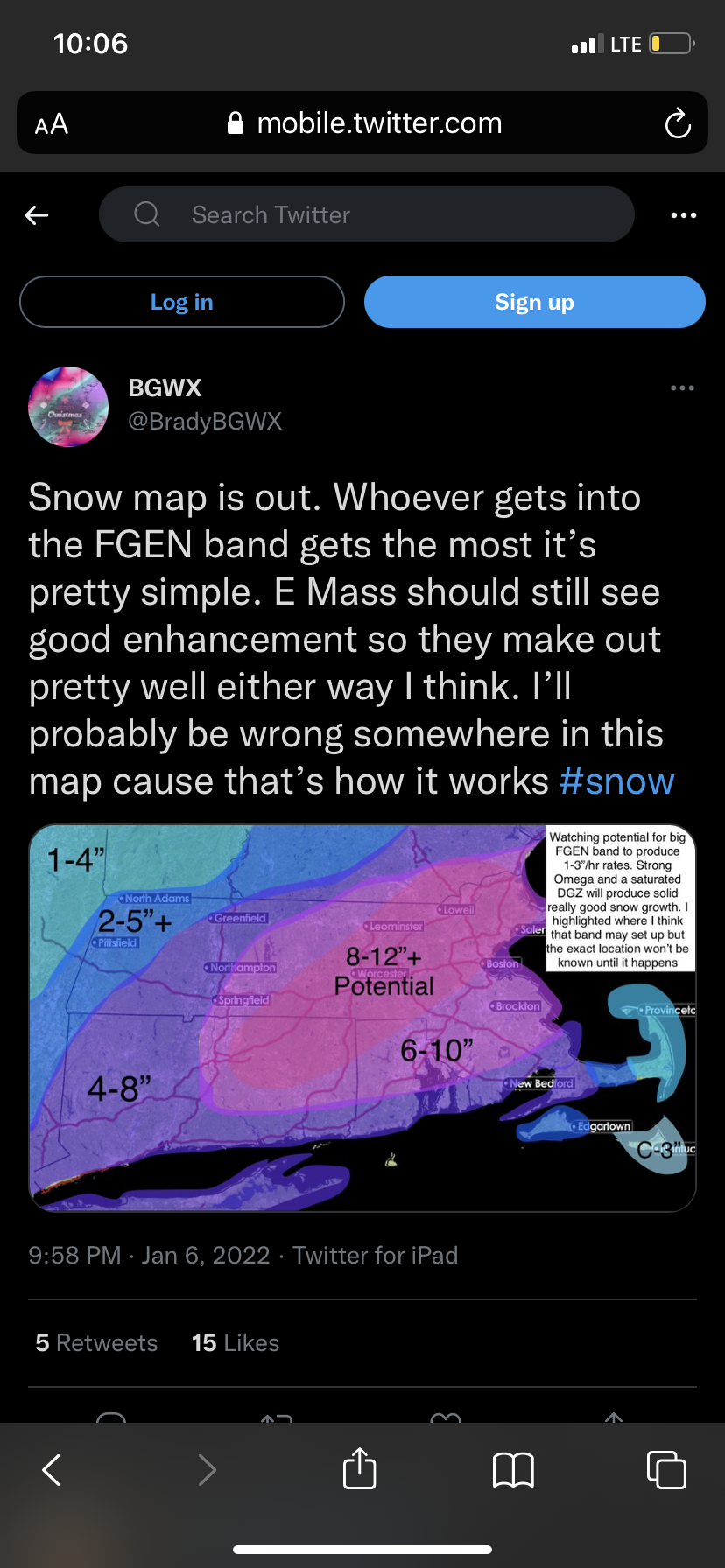
A snow map I saw on twitter, looks better than these convection chasing models that have barely .5 QPF even in eastern mass. I agree with this map.

-
Ok I probably shouldn’t have said the eastern low won’t be real at all, its there but weaker then expected, satellite looks better than the models do. There is still a chance that the western low will take over and absorb the eastern low.
-
We still don’t know if that eastern low thing will even be real. The upside is still there, we will find out in a few hours.
-
the nam has initialization errors, too strong with the eastern low and too weak with the western one to begin with.
-
Biggest positive busts I can think of that happened recently were the Super Bowl storm last year, March 14 2018 blizzard, one early Feb 2016 and March 2019.
-
March 8 2013? I don’t know exactly what happened, but I read that the eastern low got absorbed by the western one or something weird like that happened. Anyways that storm I was forecast to get 2-4, got 20.