George001
-
Posts
6,140 -
Joined
-
Last visited
Content Type
Profiles
Blogs
Forums
American Weather
Media Demo
Store
Gallery
Everything posted by George001
-
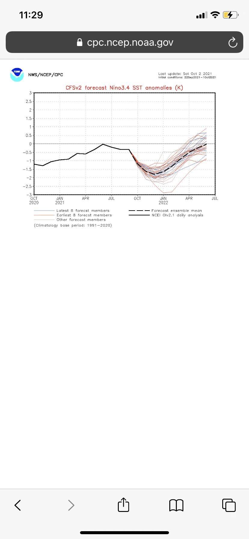
Update: the ssts have improved.
-
I’m just glad the polar vortex is expected to be weak. The timing of a severe polar vortex disruption can be figured out later. If it happens in January instead I would think that means our best pattern would be mid Jan to mid Feb. Hopefully the polar vortex is farther east than last year when the severe polar vortex event caused it to intrude into the west instead.
-
Yeah that’s a huge difference. 12 degrees above average for December is insane. The 2015-2016 winter was horrible with the super nino. Fortunately this winter we won’t have anywhere near a strong El Niño.
-
I stand corrected. I don’t remember 2009-2010 being quite cold here but I was just thinking both were warm and lacked snow in my backyard, both strong ninos, ect. I thought 2009-2010 was only snowy in the mid Atlantic and not New England. That 2009-2010 winter really pissed me off because everything kept missing to the south so I am admittedly a bit biased. Do you guys think that maybe the 2009-2010 pattern wasn’t bad but we just got unlucky?
-
How strong do you think the Nina will get looking at the latest trends? I do think that is overdone, but it is telling that the models aren’t backing down at all and are getting even more aggressive with increasing the strength of the La Niña with the latest forecasts. I’m thinking around -1.6 or so for the peak right now.
-
The next month will be very telling, as the cfsv2 is forecasting a rapid strengthening over the next month, bringing the Nina from weak now to strong by early November, and then peaking in December as a borderline super Nina at -1.9.
-
09-10 was a fairly strong nino. I am very critical of Joe for his views on climate change, 09-10 actually ended up being a decent analog for the 2016 winter (both winters sucked up in New England, great in the mid Atlantic). I don’t consider either 09-10 or 15-16 to be snowy or cold winters at all, so Joe wasn’t entirely off base there. That said, this winter there will be no El Niño. It is more likely that I die tomorrow from a giant meteor strike than it is of an El Niño developing for the winter. La Niña is increasing in strength, and is already up to weak territory. It is around -.7 right now in the enso 3.4 region, and the strength of the La Niña will only continue increasing with the subsurface being even colder than last years at this time. I could be wrong here but I do believe the surface will catch up, and it will catch up fast. In my opinion, the La Niña will not be weak. The CFSV2 is forecasting the La Niña to peak at nearly -2 in the Enso 3.4 region, which is borderline super Nina territory. This is likely overdone, but other models have increased the strength of the La Niña as well. Euro moved from weak to moderate, NMME moved from moderate to strong. I am actually thinking that it is more likely that the La Niña peaks at strong than it is for La Niña to stay weak with how things have progressed recently. High end moderate/low end strong is where I am leaning, a middle ground between the cfsv2 and less aggressive guidance like the euro.
-
I’m very excited for this upcoming winter, it’s a great sign that the polar vortex is weak.
-
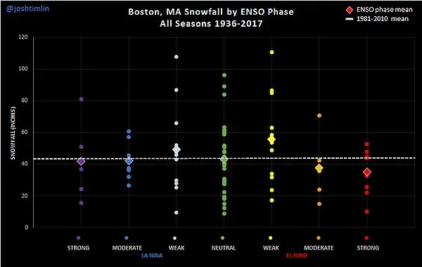
That’s only true for the lower mid Atlantic. NYC North does just as well in strong Nina as enso neutral. Strong Nina+ severe North Atlantic blocking is an extremely good combo for snow in New England from what I have read. If the polar vortex was forecast to be strong then I would be worried about storms burying Wisconsin while we rain, but it is forecast to be weak. I do believe the strength of the La Niña will increase to just below 2010-2011 levels. Many weenies panicked and canceled winter that year too when they saw how powerful the La Niña was, but then us New England weenies got buried. It’s not like the La Niña drastically weakened or wasn’t coupled to the atmospheric pattern either, it was well coupled and while we got buried by blizzards in December and January, the La Niña was strong.
-
Ok that makes sense, so even though a trough in the west is more likely in Ninas it’s not necessarily bad here if we get blocking. With blocking it would force the lows that initially cut into Wisconsin due to the trough in the west to redevelop off the coast and turn into Miller bs that bury us with feet of snow. That explains why the risk with stronger ninas is rain while Wisconsin gets buried, where as the risk with strong ninos is DC getting buried. I do believe the North Atlantic blocking will be severe so maybe when combined with the trough out west, it will still end up being an epic Miller b pattern with 5-6 blizzards in eastern mass this upcoming winter.
-
What? I don’t understand….. how is that possible, if it means a trough in the west how are we averaging more snow in La Niña than moderate or stronger ninos? How is weak La Niña the second snowiest Enso state. I thought La Niña meant a more active northern branch and a weaker pacific jet due to less warm air flooding the country. I hate it when there is a trough in the west, it seems like when that happens it always gets too warm for snow here and the blizzards end up burying Colorado instead of here.
-
As long as we don’t have a trough in the west with the expected North Atlantic blocking the La Niña should help us prevent storms from missing to the south and burying DC and Philly.
-
Where’s the 2010-2011 winter? There was over 80 inches of snow that winter, and the La Niña was strong. The chart I saw had strong La Niña, moderate La Niña, and enso neutral all at roughly the same snowfall average. This chart also had the 2010-2011 winter with the highest dot in the strong La Niña category being at right around 80.
-
Only 2 blizzards the whole year
-
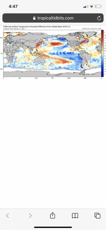
I was not aware of that, that is good to know. That is a valid concern, the water is just too warm off the Newfoundland coast. Hopefully the ssts there start to cool. However, the models are still saying the polar vortex will probably be weak, and the pacific ssts are still looking great so if we can get the polar vortex to cooperate this winter should be much better than last winter.
-
The panicking about the increase in strength of the La Niña on the models is becoming widespread. It is justified for mid Atlantic people but for us if anything with the sst profile and expected weak polar vortex it is a good thing.
-
In the mid Atlantic yes, NYC north no. The La Niña= bad thing is a myth, the two worst Enso states for snow are moderate and strong El Niño’s. You have roughly the same snowfall average in a strong la nina and enso neutral. I live in eastern mass and I am extremely excited about the increase in strength of the La Niña when combined with the sst profile.
-
Love to see it, the strength of the La Niña is increasing. Not only that, but the SSTs are starting to trend favorable off the west coast. The pacific ocean as a whole is cooling off, while the ssts remain warmer around the North Pole, which should help weaken the polar vortex. This is a great sign for a severe New England winter. 2010-2011 redux.
-

Some Thoughts on the Winter 2021-22 Outlook
George001 replied to OHweather's topic in Weather Forecasting and Discussion
Average temps in Feb? After the last few years I would gladly take that and run. Hell even slightly above average like +1 isn’t that bad. Average to slightly above avg temp but with a stormy pattern can still mean a very snowy month in New England. -
Nope, that pattern would be great with North Atlantic blocking. In my opinion the lack of blocking is probably bullshit due to the weak polar vortex. The models are also likely overdoing the strength of the pacific jet because the strength of the La Niña is increasing more than expected. That should help cool the ocean off, preventing the pacific jet from strengthening and flooding the country with mild air. 200 inches is not the most likely scenario but it is very possible with the polar vortex expected to be one of the weakest on record.
-
With the polar vortex forecast to be extremely weak, that lack of North Atlantic blocking is probably bullshit
-
In my opinion this year they are viable analogs. The models are forecasting an extremely weak polar vortex, and combined with the SST profile it is likely we see plenty of North Atlantic blocking in the first half of the season. The strength of the La Niña is also drastically increasing, with a likely 200+ ACE index hurricane season going on the books everything is lining up for an extremely snowy New England winter. Moderate-strong la ninas with severe North Atlantic blocking is a great pattern for snow in New England (Miller Bs). When you get an active hurricane season like that, all those storms will buckle the flow, causing it to slow down and give storms more room for to dig, go negatively tilted and undergo rapid cyclogenesis. Then you have sever North Atlantic blocking on top of that, increasing the ceiling even more. We are lined up to not only see a big 20+ inch Miller b blizzard NYC north, but we are lined up to see 3-4+ of them. I honestly think this winter has a very real shot to be better than 1995-1996. I’m starting to consider the possibility of doubling 1995-1996 in the Boston area if we get a few lucky breaks with the pattern that is shaping up, the ceiling is that high. I truly believe this upcoming winter is going to go down in the record books as a 1 in a million type weather pattern, one that even considered to be possible in New England.
-
That is a strong central based La Niña, which combined with an extremely weak polar vortex would make for a very interesting winter in New England. The La Niña should result in a farther north and west storm track, likely many lows coming up through Chicago or even Wisconsin! I know that sounds bad but when you have lows coming up that far west while there is North Atlantic blocking in place, we would likely see the lows transfer to off the Jersey Shore or south of long island, and then come up the coast. Yep, that’s a Miller B pattern! DC and Philly aren’t going to like it very much, they would just get rain or only a couple inches of snow at most, while NYC and Boston get buried. The severe blizzard last December had that exact track, and Wisconsin, NYC, and Boston all experienced blizzard conditions. I still remember before the storm there was a big argument over on the other forum that I’m banned on, with half the people arguing that the storm would be a Miller A that would bury the mid Atlantic (gfs camp), and half arguing that the storm would be a Miller B that buried NYC north (Euro/Canadian/Navy camp). In the end, the la nina ended up winning that battle and the storm shifted like 500 miles north on the models just 2-3 days out! It was amazing, the forecast amounts went from 2-4, to 4-8, to 8-12, and then a day before the storm hit the models all converged on a Miller B and the TV Mets upped the forecast in my area to 12-18. I ended up getting 15, when just 3 days ago Philly/DC was expected to get hammered while we were on the northern fringe, expected to get at most 4 inches. Instead, they rained, we got a foot+, and the jackpot was actually north of us, Binghamton NY got 4 feet! If it weren’t for the La Niña, that storm likely would have hammered Philly and DC while we got nothing!
-
Woah! The latest update of the CFSv2 has the MEAN down to -1.8 and one member increases the strength of the La Niña to -3! The surface has cooled quite a bit over the past week, and is expected to continue cooling in the enso region into late fall/early winter. If this ends up being right, it would have major implications on the winter forecast.
-
I’m going all in with the navy on this one, so I’m leaning towards 50+ ACE. The strength of the La Niña is increasing, which combined with the pattern on the models is making me very bullish on the back end of this hurricane season. At 128 already, with Sam possibly taking us to 140 or so even if we have an average La Niña rest of hurricane season (30 or so ace after Sam), that would put us at 170 and that’s ignoring the Navy. If the Navy is right we could see 220+.