George001
-
Posts
6,140 -
Joined
-
Last visited
Content Type
Profiles
Blogs
Forums
American Weather
Media Demo
Store
Gallery
Everything posted by George001
-
Woah! The strength of the La Niña is increasing quickly. I know you have said earlier you think it peaks at around -1.2, do you think we are close to peak strength right now or are you starting to think it may even become a strong La Niña?
-
What is more concerning is that we are setting records for warmth almost every year. Climate change is not only there, but it is accelerating. The increase in average temperature hasn’t yet resulted in less average snow in our area, but it has in areas to the south like DC. I do believe we will eventually reach a point where the increased ocean temps allowing lows to bomb out more and deliver big storms will not be enough to overcome marginal events that used to be heavy wet snow turning into a cold rain, even here.
-
Strength wise the la ninas are similar (at least to this point, that could change as we get to Dec and Jan), but the structure for this one is much more favorable. It’s more basin wide vs central based, which is a good sign for a more favorable pacific with less troughing in the west. The pacific blob is in a bad location like that year, but the polar vortex is forecast on the models to be weak. I truly believe this winter will be a lot better than 2011-2012, just gotta get North Atlantic blocking.
-

George’s official winter forecast for the Boston area
George001 replied to George001's topic in New England
You bring up a good point about the solar activity, it has been increasing lately. If it keeps increasing, that could be a big red flag. That will definitely need to be watched. For the nor’easters timing up with periods of weakening blocking, that can work if the pacific cooperates, but if the western ridge is too far west, we could see a scenario like last year where the gradient is just to the north and west of the Boston area. -
George’s official winter forecast for the Boston area
George001 replied to George001's topic in New England
I did it, I went big. The La Niña structure being basin wide instead of central based (it went more west based in late February and March last year, this year I believe if anything it goes more east based latter half of winter, and we will see it’s influences in March) is huge. The polar vortex expected to be weak with a severe hurricane season in the fall makes me think we could see things get wild with a cold and stormy pattern especially in January. The reason why I didn’t go all in on 1995-1996 is I think the pacific warm blob being that far west will come back to bite us in the ass in Feb, leading to a trough in the west. I believe the pacific will be much better than last year, but worse than 1995-1996. I actually think it’s good that the blocking in Jan won’t be as severe as last year, we missed on quite a few lows to the south with the blocking being so extreme it was bad. -
After a strong start to the 2020-2021 winter, winter ended (late Feb) due to the polar vortex rapidly increasing in strength, leading to a snowless March in New England. This year, we have some mixed signals. - warm waters off the east coast - basin wide La Niña (strength is a big wild card, my forecast is -1.2 to -1.6, moderate to strong) -warm waters near the north pole - the entire pacific has rapidly cooled off, a much different look than the past few winters -polar vortex is expected to be weak in mid December on the models -warm blob in the pacific is smaller than it has been, but it is there and fairly far west -Siberian snow cover is average to below average With the recent shift in guidance from a weak polar vortex in November to a strengthening polar vortex in November and weak polar vortex in December, the timeline for our windows of opportunity have shifted. Due to the polar vortex and warm waters off the east coast, I do not believe there will be snow from November to early to mid December in Southern New England outside of the Berkshires. The pattern in my opinion will be quite unfavorable, and we are going to have to kick the can to later in December. However, we will be wasting shit climo anyways with the unfavorable pattern, by mid December with the weak polar vortex in place combined with the favorable ssts for North Atlantic blocking, I expect there to be a window of opportunity from the 3rd week of December, to early Feb. There is a strong signal for blocking to develop, however I do not think the blocking will be as strong as it was last Jan, due to the limited Siberian snowcover advance. Then we have our next strongest pattern driver, which in my opinion will be La Niña. Some years, Enso is kinda just there while other factors dominate the pattern, this year I believe the main drivers will be polar vortex and La Niña. I am forecasting a moderate to strong La Niña (-1.2 to -1.6), and I do believe it will be a major pattern driver due to other atmospheric measures besides the temperature in the Enso region itself reflecting La Niña (SOI index, the MEI index, the entire Pacific cooling off ect). Many snow weenies (besides myself) are probably going to panic and think “Moderate to strong La Niña dominating the pattern, winters going to suck!” That is not necessarily the case, the 2010-2011 winter had a strong La Niña, and it was very well coupled to the atmospheric pattern. In my opinion this winter will ultimately come down to a battle between the polar vortex and the La Niña, with a much weaker pacific jet than we have had recently. The northern branch will likely dominate, and when combined with North Atlantic blocking in that late Dec to early Feb window, the entire pattern will be amplified with the northern stream digging fairly far south in the middle of the country, causing a low to develop and cut up into Ohio or even as far west as Wisconsin in some cases, which happens in La Niña. Without blocking this would be VERY bad, but blocking will turn these would be rainstorms into slow moving Miller Bs that undergo rapid cyclogenesis due to the contrast with warm ocean temps and the Arctic air in place, courtesy of the polar vortex. I do think we will get 6-10 chances in this time frame, with the room for error being higher due to the amplified jet stream making it easier for the northern branch to phase with whatever leftover energy there is near the gulf (that said, I’m expecting 2-3 hits) Unfortunately, I do think the polar vortex will recover and start deepening in Feb, when combined with the North Atlantic blocking disappearing and La Niña in place, I do believe we will probably see a trough in the west. It sucks, but even the best winters can’t be wall to wall, even 2014-2015 we wasted December and the 1st half of January before the polar vortex took over and we got buried. This part of the forecast is where things get very tricky. Will there be another polar vortex disruption (right now, I am not seeing any signs of a split like last year for the 1st polar vortex event)? If there is, that could cause March to get wild, with the potential for us to see 60s and 70s in mid Feb going to blizzard conditions in early March. The QBO being negative from what I have read makes the polar vortex more susceptible to being displaced or split. I do not expect a split in the first half of winter, I expect the vortex to weaken, but not enough to cause a split. mid Feb to early Mar however, I believe we have a high probability of seeing a split or displacement. Summary- Boston Nov- +2 to +4, 0 inches of snow Dec- 0 to +2, 10-15 inches of snow Jan- -3 to -2, 40-45 inches of snow Feb- +4 to +5, 0-10 inches of snow Mar- -4 to -2, 20-25 inches of snow Dec-Jan total: temps- average to slightly above Snowfall- 70-85 inches analogs ranked from best to worst 2017-2018 (on roids), 2010-2011, 2012-2013 (bad timing w/ big feb and weak Jan, but like it for March and the high ceiling blizzards), 2020-2021
-
It has been quite warm this month but the pattern has changed to a cold and wet one. Right now, that means a lot of rain. In the winter, it means we’re getting buried. The North Atlantic blocking is there, and I don’t remember there being any sign of it in 2011. I really like the way things are looking right now.
-
That look one month later would be really interesting
-
The low is rapidly strengthening off the Jersey coast right now, and is forecast to come up the coast, stalling just se of cape cod and doing a little loop. I don’t see why that wouldn’t be a blizzard in the winter with 2’+ totals considering how much qpf we are getting now (2+, in some areas 4-5 in) It probably wouldn’t be nearly as high in the winter to be fair since the oceans will be cooler, leading to the low not strengthening nearly as much. However it would still be a slow mover and that is how you get those really big snowfall totals. We have severe North Atlantic blocking in place right now, which increases the ceiling and is why this storm is producing so much QPF now.
-
I love to see these big rainstorms at this time. I don’t know how true this is but I have heard that when there are big nor’easters in the fall, often times that is a good sign for winter because we are establishing a favorable storm track, and those wind driven rainstorms now will be severe nor’easters with blizzard conditions at times in the winter.
-
The models are saying peak in November or early December that’s not really a late peak. It’s already at -.8 in the Enso 3.4 region so I wouldn’t be surprised to see the the surface continue catching up to the subsurface, leading to the Nina drastically increasing in strength. That’s nothing to panic about if you live north of NYC.
-
Boston does well in la ninas, even moderate and strong ones. The La Niña drastically increased in strength in the fall of 2010, which caused Boston snow weenies to panic and write off winter before it began. However, Boston got 80+ inches of snow that winter with multiple severe blizzards. I believe the la nina will increase in strength and become strong, but Ray or 40/70 benchmark isnt a weenie he knows his shit. Read his blogs, he is a really good forecaster and nailed last years winter forecast, he could very easily end up being right about the La Niña being weaker than many of us expect.
-
Didn’t 2007 have a lot of quick moving 6-10 inches of snow to rain events, with a sharp gradient? If we had that type of pattern but with some blocking, would that would mean many of those quick movers that go over to rain at the end become slow moving miller bs that stay snow?
-
Yeah if that happens then it’s time to start panicking. I remember things looked good initially the 2019-2020 winter, many called for a big winter and it even started off well. In my area in eastern mass we got a nice storm in early December, and there were a lot of big storms on the models. I was super excited, but then within a week the long range models shifted from forecasting a polar vortex displacement to a rapid deepening of the polar vortex and consolidation over the North Pole. After Mid December or so the new pattern took hold and didn’t let up, leading to what started as a promising winter turning into a 2011-2012 redux. I do remember Isotherm went against the grain and called for a mild winter that year, and ended up being right.
-
When I initially heard about the polar vortex I started to panic a bit, but looking at that graph it isn’t that bad. Yes, the polar vortex recovers and strengthens to above average in mid November, but it starts to weaken again back to average by early December. If that’s true it means we are ****ed…. for November which isn’t even winter anyways. I’m not going to panic about a likely snowless November, as long as the polar vortex doesn’t deepen from dec-mar New England should be fine in my opinion. I am still extremely bullish on this winter. I believe it will be the best winter since 2014-2015 (and that says something because 2017-2018 was really good) NYC north. South of there id be more nervous with the increasing strength of the La Niña.
-
Looks like he’s going for an average winter in eastern mass with a bit above average north and west. I wouldn’t say it’s a particularly aggressive forecast. Nothing wrong with that, he could very well be right. Hopefully we get a little bit more blocking than expected and a cooperative polar vortex. Signals are mixed right now, I’m looking forward to seeing Rays and Isotherms forecasts in early November.
-
If all my forecasts came to reality
-
My area has been getting skunked lately, since that awful super nino I’ve had 2 average winters (2016-2017, last year), 1 decent winter (2017-2018), and 3 garbage winters (2015-2016, 2018-2019, 2019-2020). As good as 2017-2018 there was only really 2 massive blizzards, last winter with 3-4+ blizzards was 2014-2015, every year I get my hopes up for some reason or another and then something goes very wrong and we get 70s in mid winter! Hopefully this year things will be different, with not even one 60 degree reading the during the Dec-Mar period. This is probably unrealistic especially early Dec and late Mar, but I’d like to see a winter with no 60+ readings late Dec to early Mar, those really warm days are a snowpack killer.
-
Maybe the truth will be somewhere in the middle, the earlier runs were saying the polar vortex would be extremely weak and not recover at all, now they are saying that while it will be weak, it will start to recover and drastically increase in strength. A middle ground solution might still be good for us, something like the polar vortex recovering some, but moving to eastern Canada instead of the North Pole.
-
Shit that’s not good. If the polar vortex recovers, it’s possible that the Boston area ends up with yet another garbage winter with less than 40 inches of snow the entire winter. That’s awful, hopefully the polar vortex doesn’t recover at all. edit- just watched the animation on that particular model and not only does the polar vortex drastically increase in strength, but it moves over the North Pole. If that happens 2011-2012 becomes a good analog, which means cancelling winter is in the cards. I’m not ready to give up yet, but seeing that it makes sense why many people here are being cautious about forecasting a big winter.
-
the models are saying the polar vortex is expected to be weak to start the year. Thats a great sign, and should lead to severe north atlantic blocking. I have read that a weak polar vortex has a strong correlation to blocking from 2 weeks out to like 8 weeks out, so that would result in an early window from early December to mid Jan.
-
I don’t get it things look really good with the La Niña and expected weak polar vortex+ expected North Atlantic blocking. This winter should at least be better than last, hopefully a lot better.
-
2007-2008 was pretty good in my area, that pattern as a whole doesn’t look terrible. If we can get that cold in Canada a little farther south that pattern would be great even in NYC. I do believe the models are underestimating the North Atlantic blocking.
-
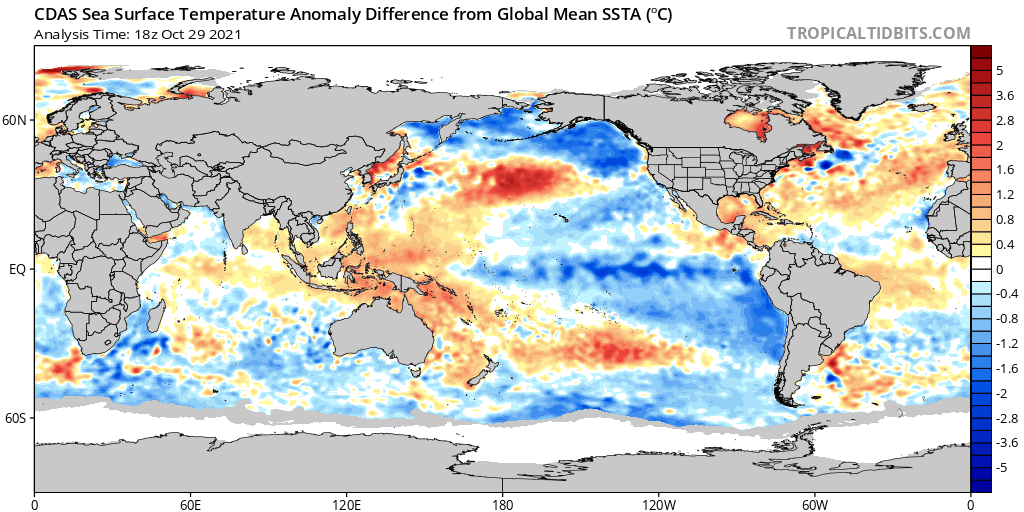
https://www.washingtonpost.com/weather/2021/10/14/la-nina-winter-forecast/ On Thursday, NOAA officially declared that we are in La Nina.
-
Looking at the picture above, the following things stand out: the strength of the La Niña has increased. a cold pool is developing close to Newfoundland. It’s not in the perfect location, but is close to that Tripole look mentioned earlier, a strong indicator of North Atlantic blocking. The pacific is still kind of bad. I hate the warm blob being that far west, that could be a sign that there will be a trough in the west at times in the winter. In 2010 it wasn’t great either but the size of that warm blob was smaller. However, the pacific does not appear to be as bad as last year. Last year had a more expansive warm blob, and pretty much the entire pacific was a furnace. This year outside of the warm blob there is colder waters surrounding it, the structure looks similar to 2010-2011 more so than last year. From what I have learned from Rays blog (easternmassweather), the structure of the La Niña favors more east coast troughing when the colder waters are displaced to the east, with a less favorable pattern and more of a trough out west when the Nina is west based. This la ninas structure actually looks a little better than 2010-2011 (though the strength is much weaker at least right now, by October 2010 the La Niña was already strong). It is a subtle shift, but the cooler waters appear to have moved east a bit as it strengthened. It’s fairly basin wide right now, we will have to see how it looks in a month as the Nina continues to strengthen, but if it maintains or moves east that’a good.