George001
-
Posts
6,140 -
Joined
-
Last visited
Content Type
Profiles
Blogs
Forums
American Weather
Media Demo
Store
Gallery
Everything posted by George001
-
If the polar vortex is still deepening into January then I’ll give up on winter but there is still plenty of time.
-
Exactly, the people who are calling for a mild snowless winter are going to be in for a big surprise. The winter of 2010-2011 had an extremely strong La Niña with a supposedly “bad mjo” at times yet there were still multiple blizzards in my area that year. This La Niña is even more east based than that one was, though it is also weaker (moderate strength rather than strong, but still powerful enough to influence the pattern). The MJO looks pretty weak to me right now, and there are signs of severe North Atlantic blocking for early December. This winter has a lot of potential. The La Niña= bad thing is not accurate for NYC north.
-
The models have a great setup for the Nov 25th window, strong North Atlantic blocking developing with the La Niña induced active northern branch digging south. That has the potential to develop into a Miller B. The chances of a major storm are very high, the risk (especially in eastern Mass) is that the cold air supply is limited. We will need the low to undergo rapid cyclogenesis about 200-300 miles southeast of where it’s modeled on the european guidance to get a major snowstorm in eastern mass. I am expecting in my area for this to be a big rainstorm, but it could be big for areas north and west. It also looks like the start of a great pattern heading into December, this pattern with more cold air in place has a lot of potential.
-
I disagree with both of you. I agree with you that the La Niña will explode in strength come early December, but I disagree with you about the implications it will have on our winter in New England. While it is strengthening it is becoming more east based, which is good for us. As is typical with la ninas (especially one well coupled and of decent strength like this one), the northern branch will be more active. However, due to the structure of the La Niña from what I have read east based structure leads to a more favorable pacific pattern, with less troughing out west and a weaker pacific jet. If we can get North Atlantic blocking (There are signs of it coming in mid to late December into January), I would think it would buckle the flow. When combined with limited pacific jet influence that’s an amplified pattern with plenty of cold air in place. That’s a really damn good pattern for us in New England, east based mod-strong La Niña with North Atlantic blocking and limited pacific jet. It’s not going to be a true east based Nina, more east leaning basin wide as a Nina of this strength is going to expand into nino 4 as well. That’s still good though, the strong Nina= bad thing isn’t really true for us. In late Dec 2010, the official strength of the La Niña was 1.6 ONI, the MEI was below -2, and the SOI was raging positive with an extremely negative PDO. By all accounts, it was a strong La Niña that was well coupled with the atmosphere and a major pattern driver. I also got buried by 18+ inches of snow. In Jan 2011, 2 major blizzards in my area, they occurred while the La Niña was strong and driving the pattern. We had the same blocking pattern the year prior, and New England got skunked while the Mid Atlantic got buried in a strong west based El Niño pattern. Based on what I have seen, I am making no changes to my winter forecast. Mod-strong La Niña, 70-85 inches of snow in the Boston area. Yes early Dec is showing signs that it will be warm. There is still 3 and a half months of winter left after that, and the European guidance is saying the PV weakening is delayed but not denied. Strengthening of the La Niña is no reason to give up on winter.
-
This is a very simplified explanation, as I have a very basic level of understanding of this stuff. From what I understand, it means increased probabilities of Miller B nor’easters vs a more west based basin wide La Niña. For a more in depth explanation Ray discusses the forcing mechanism of the structural nuances on the Enso region in his blog post on the winter 2021-2022 forecast.
-
It’s interesting how the strongest negative anomalies are moving east as they surface, which could be a really good sign for a more favorable structure (more east based, basin wide right now) for winter taking hold as the La Niña continues to strengthen in the near term.
-
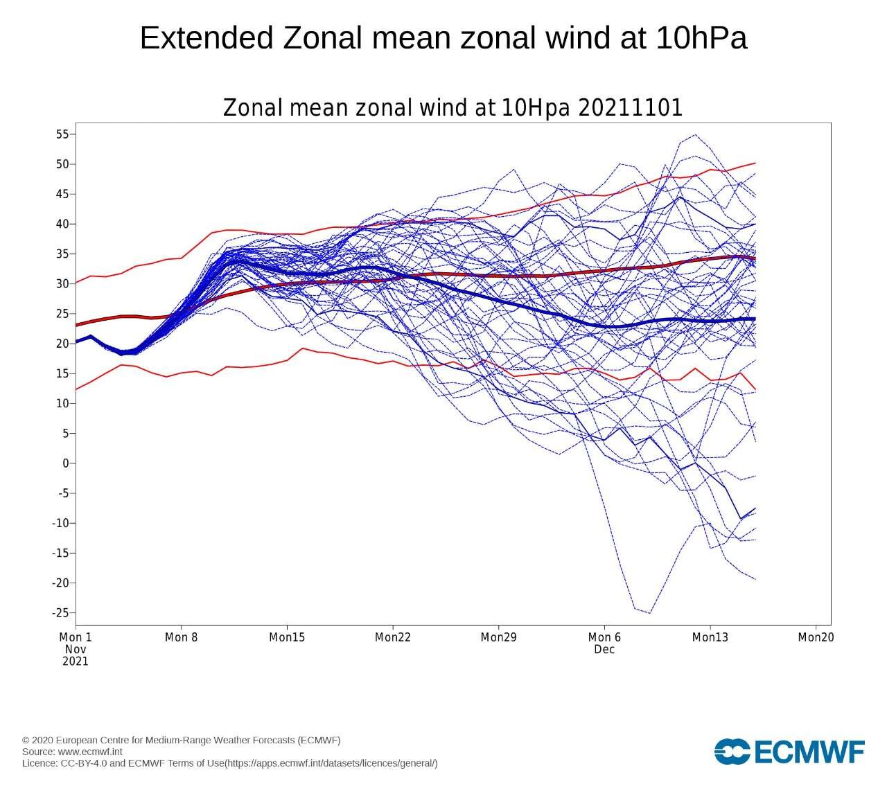
The gfs has a strong polar vortex throughout December wear as the Euro weakens it late December. The weakening of the polar vortex has been delayed a bit, but not denied in my opinion. As for the La Niña, the subsurface is starting to weaken but there is still significant negative anomalies just below the surface. These negative anomalies are rising to the surface, and should help strengthen the La Niña further. We are already at -1.0 on the weekly reading in the Enso 3.4 region, and with further cooling expected a moderate peak is very likely. A well coupled La Nina peaking at the -1.0 to -1.2 range isn’t exactly weak.
-
Guys get a look at the Canadian 200 hours out, it’s a coastal scraper but a massive 972 mb low offshore. If that comes up the coast, while cold air is marginal at this time of the year, due to the strength of the low, it would undergo rapid cyclogenesis and create its own cold air via dynamic cooling. That would result in severe blizzard conditions from NYC to Maine. The storm is caused by the northern branch diving to the south, tapping into the warm gulf coast waters, going negatively tilted. The low then transfers from the Midwest to off the mid Atlantic coast, turning into a Miller B. This is a low probability at this time (due to climo and limited North Atlantic blocking), but the model guidance is forecasting North Atlantic blocking to develop a couple days later. If that develops just a little earlier, the probability of this massive nor’easter coming to fruition increases. More likely, things don’t quite come together, but then when the North Atlantic blocking develops the last week of November, we start getting big winter storm threats.
-
Ray, I am wondering what your thoughts are about the pattern presented on the CFS from Jan-Mar. In Dec, the pacific looks decent, but with the lack of blocking I agree your area is in a much better spot than us in se ma. With the look the CFS has in January though I’d take the overall pattern it has for the winter and run. That January pattern looks straight up epic. Feb and March, im not a fan of the trough out west. But March looks to have some blocking and both Feb and Mar have a nice look on the precip charts. Maybe the Feb-Mar look would be something like 2005-2006 with a mild pattern overall, but active pattern with chances at a big one?
-

2pm Saturday, 11/20 @ Funky Murphy's ORH
George001 replied to 40/70 Benchmark's topic in New England
I’m not sure if I’ll be able to make it or not but I might stop by, can someone DM me the address -
It’s weakening a little earlier than anticipated but make no mistake, this is a real La Niña that is well coupled with the atmosphere. The MEI value is at -1.5, that doesn’t happen in a La Niña that isn’t well coupled to the atmosphere. There has also been significant cooling over the past couple months off the northern pacific coast, another indicator that La Niña is already driving the atmospheric pattern. Strength wise, it is expected to be a low end moderate La Niña, maybe a tad weaker strength wise than last year (last year was -1.3, this year probably -1.1 or so peak). However, this La Niña despite being weaker is more well coupled to the atmosphere, the MEI is higher, the northern pacfic ssts are cooler ect. La Niña isn’t going to fade into the background while other factors drive our winter pattern, La Niña will likely be a major pattern driver, even more so than last year despite being a tad weaker.
-
That type of pattern would be a high ceiling one on New England, in some of the mid Atlantic boards they cringe at the thought of Miller Bs, but those Miller Bs that screw them over often bury us. It seems like Miller As just don’t have the crazy high ceiling Miller Bs do. Jan 2015, Feb 1978, Feb 2013, Jan 2005 ect all Miller bs.
-
Yeah it’s not good yet, but it’s close and if you extrapolate those 2 maps above to later December I would think the pattern becomes great. North Atlantic blocking looks like it is starting to develop there, even with a trough west of ideal that can work. The blocking should help turn those lows initially running inland redevelop off the coast and turn into Miller Bs.
-
Honestly I expected it to strengthen and peak mid to late December or so, in my forecast I said I thought it would peak -1.2 to -1.6, I was leaning high end a couple weeks ago but now it looks like the people who were calling for high end weak/low end moderate will be right. That’s kind of a big deal for areas farther south, don’t know about where I live. I have heard earlier peaking ninas are more favorable anyways, I would think by the time winter hits we’re going to be in a full blown Nina pattern due to the lag effect. Everything is lining up for at least a good winter in the Boston area. Whether or not it’s great remains to be seen.
-
Yeah ninas are better for NYC north generally. In the winter of 2010-2011, the la nina was quite strong at -1.6 degrees Celsius. In 1995-1996 however, the La Niña only peaked at -1 degrees Celsius. In weaker ninas it seems like the pattern isn’t as hostile as stronger ones in the mid Atlantic, though still not as favorable as a nino for you guys.
-
March 2018 was wild, I remember mid month there was a massive 960s mb storm that was offshore, but the precip field was so expansive that when combined with the North Atlantic blocking in place, it resulted in severe blizzard conditions in eastern mass. My area got so much snow (there was already about 10 inches on the ground from a previous storm a few days ago), that due to the weight of all the snow, a huge tree fell in my backyard and we hired someone to remove it. I’m not sure the exact totals, but eyeballing it looked to be at least 20 inches of snow from that storm. Nearby towns reported in the range of 20-24, and I believe some areas farther north got close to 30 inches.
-
Winter 2021-2022 Outlook
George001 replied to 40/70 Benchmark's topic in Weather Forecasting and Discussion
Great read, the fast start, mild period mid winter and big March you are forecasting is very similar to 2017-2018. That was a great winter. -
I’m not a fan of the overall look, December looks good with North Atlantic blocking and a ridge out west. January has the blocking which is great, but there is a massive trough out west. I hate that, hopefully it goes away. February and March are straight up garbage with no North Atlantic blocking and all the cold air locked up around the North Pole. That is a strong polar vortex pattern. This winter pattern verbatim would go out with a whimper and probably be below average in eastern mass. I do think it’s a few adjustments away from being good though, just need a more favorable polar vortex intrusion with it coming into the east instead of out west in Jan, then get one more polar vortex intrusion later in winter.
-
Later in December and especially January could get really interesting.
-
I probably won’t be good but I don’t think it will be awful either, it will be somewhere in the middle. I don’t expect the pacific jet to go crazy like it has recently.
-
I’m glad we are getting this garbage pattern out of the way early rather than wasting prime climo and kicking the can down the road on a pattern change to cold in mid winter.
-
I do think we punt half of December, but still end up with a big storm at the end of the month. Then January is when all hell breaks loose and we get hammered.
-
Yep, I’m going for a big winter in all of eastern mass, right down to the cape.
-
Based on what I have seen on the models, everything is going according to plan and I see no reason to panic about my 70-85 inch forecast for in the Boston area this winter. I do however believe that the pattern change will be delayed, the polar vortex is expected to deepen and consolidate over the North Pole. The European guidance has the strength of the polar vortex well above normal into the 3rd week of November, rapidly weakening in the last week. There would likely be a lag too, so I would think the pattern change is mid to late December.
-
Will November likely be a warm month? Based on what I see on the models, yes. November will likely end up several degrees above average, with not one flake of snow. However, that does not mean that this won’t be a big winter. In my winter forecast, I forecasted a very warm November due to the strengthening of the polar vortex and consolidation over the North Pole. I do expect this warm pattern to continue into the first half of December. However, by late November the polar vortex is expected to weaken significantly. There is a lag, which is why I expect the pattern change to be week 3 in December, with the potential for a severe blizzard the last week of December. Although the pattern will likely change in December, I do expect even December to average warmer than normal, but only 1 to 2 degrees warmer than normal. Where shit is going to really get wild is January, when the effects of the polar vortex event we are expected to experience in December are well underway. January is going to be our big month, with 2-4 severe blizzards from NYC north (not all will be a direct hit, someone will probably get screwed). In NYC, my forecast is this Dec- temp +1 to +2 snow 10-15 in Jan- temp -4 to -3 snow 25-30 in Feb- temp +4 to +5 snow 0-3 in Mar- temp -2 to -1 snow 10-12 in Total- 45-60 inches A warm snowless November is not the end of the world when it comes to our chances for winter. In 2014-2015, my area (Boston) pretty much punted the entire first half of winter and we ended up with 110 inches of snow. Trust the process, I’d rather be staring down a shitty October and November with a weak polar vortex expected than vice versa.