George001
-
Posts
6,912 -
Joined
-
Last visited
Content Type
Profiles
Blogs
Forums
American Weather
Media Demo
Store
Gallery
Everything posted by George001
-
I’m actually not a fan of the look on the models. They close off at 500 mb way too far south and the high leaves by the time the storm gets up here. Looks like Miller asshole to me, we need this to become more of a Miller B.
-
I hate that it looks like there is troughing out west. Hopefully it’s wrong.
-
not gonna lie, I’m getting a little concerned that my area is going to finish the season with less than 40 inches of snow. The polar vortex is deepening, not weakening and the long range models are showing a trough out west. Things can change but not looking great right now. What are some possible wildcards that could cause things to break our way and prevent the polar vortex from deepening and consolidating over the North Pole?
-
Unfortunately it looks like the breaking down of the pattern is real. We havent gotten anything out of it yet, but still have a couple of weeks left. All it takes is one big one, my hope is we get a big one, then the thaw happens but only lasts like a week. The 26th looks like it has potential with the southern energy ejecting, if we can get it to time with northern stream energy this could be our big one. The navy in particular is more amplified than the other models for that threat, which is a massive red flag that should not be ignored.
-
 Models are struggling with the pattern still, they don’t know which wave to focus on and blow up yet.
 -
If the energy keeps getting held back that’s bad for the 22nd threat, but could lead to the 24th being a big one instead as the northern stream energy behind it phases in.
-
This winter has started slower than usual but we have had plenty of winters start like this and end up great.
-
Is it possible we get both if the 24th wave slows down a bit to increase the wave spacing?
-
Just last week we had a nice storm with 6-12 for most of the area, some areas even got 14-15 inches. This storm we just had was our second threat and it didn’t work out for us. It happens, not every threat can pan out, but the pattern is still very good.
-
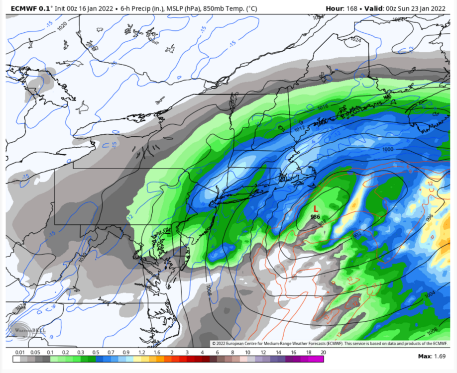
It’s only 5 days out from the storm. This is different, also it’s the best model there is. If anything these maps are underselling the potential of this storm, if it verifies like the Euro says the snow ratios will be much higher than 10 to 1. With the storm last week the models had my area getting 4-6 inches or so, but I got a foot due to the snow ratios being much higher than 10:1. The QPF the euro is projecting is expected to be around double what it was for that storm, and the low is expected to be stronger. If the Euro is correct, due to the frigid temps in the upper levels and the optimal snow growth soundings this would really end up being like 16-20 inches of snow for eastern mass.
-
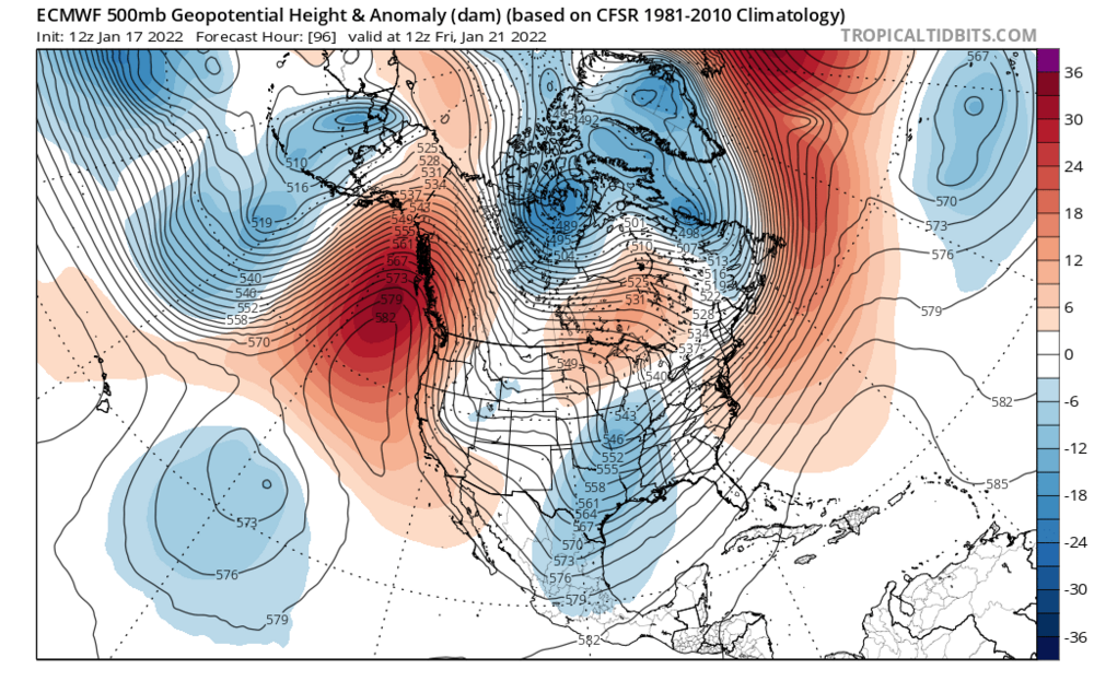
look how far west that ridge is, I don’t buy the out to sea solutions at all. If anything the concern would be an inland runner due to the lack of blocking and positioning of the ridge, but fortunately the phase looks to happen later than it did for the storm that just happened. When we have the best model on board for a big storm, it shouldn’t be ignored. It’s not like it’s 10 days out either, this run of the Euro has blizzard conditions in eastern mass just 5 days out, and it had a big storm though a bit se last run too. The Canadian has also had the storm off and on, right now it’s a bit se but it does have a low.
-
Cold blizzard is right, the temps are in the single digits nw of the coastal front over se mass.
-
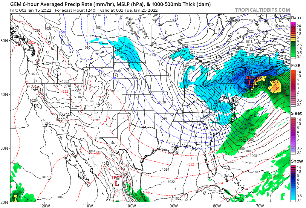
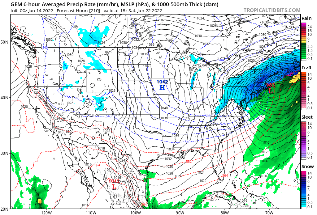
I see a 986 mb low just inside the benchmark there. Hopefully it doesn’t run inland like the storm coming tomorrow.
-
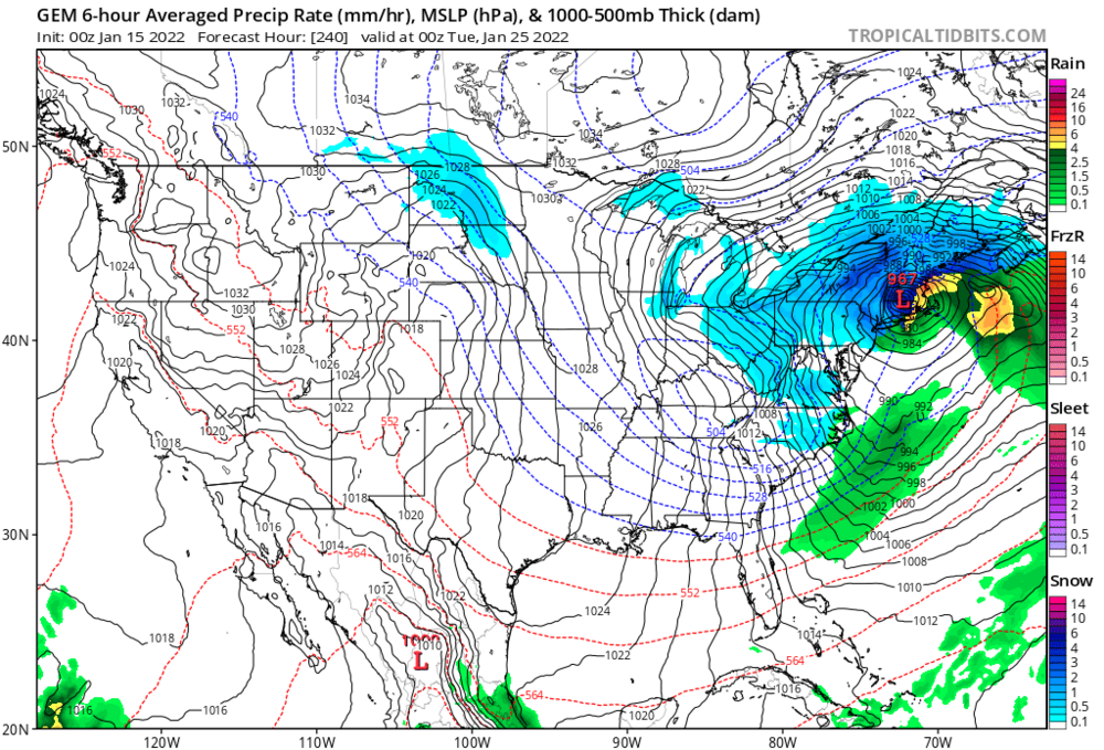
The Canadian has a 967 mb low over Western mass, but it’s snowing se of the low, that’s amazing I’ve never seen anything like it. The airmass must be insane.
-
I expect a late 2012-2013 look to walk in. Not 2014-2015 but a couple huge storms.
-
Yeah I’ve accepted that it will rain on Monday, Miller As suck you were right to call it miller asshole even when the models looked decent for a couple of runs. Nice storm for the mountains though.
-
I see a 983 mb low over Nantucket

-
Monitoring a potential important TV to East Coastal storm: Jan 17
George001 replied to Typhoon Tip's topic in New England
I know that unless the Navy is right (it’s likely too far se with the low) my area is likely cooked in terms of all snow due to the all the warm air coming inland in the upper levels. However, I do still think my area can get a few inches of snow initially before the mid levels warm up. It’s interesting how some of the inland solutions are showing signs of secondary redevelopment. If that happens, I think it’s possible if not likely that the models are too warm with the surface temps, so while it wouldn’t be more snow it could lead to more sleet and freezing rain before eventually the surface warms too and it goes over to plain rain. -
Monitoring a potential important TV to East Coastal storm: Jan 17
George001 replied to Typhoon Tip's topic in New England
I know it’s a long shot with the euro being so far west, but the navy looks great for anywhere NW of the cape.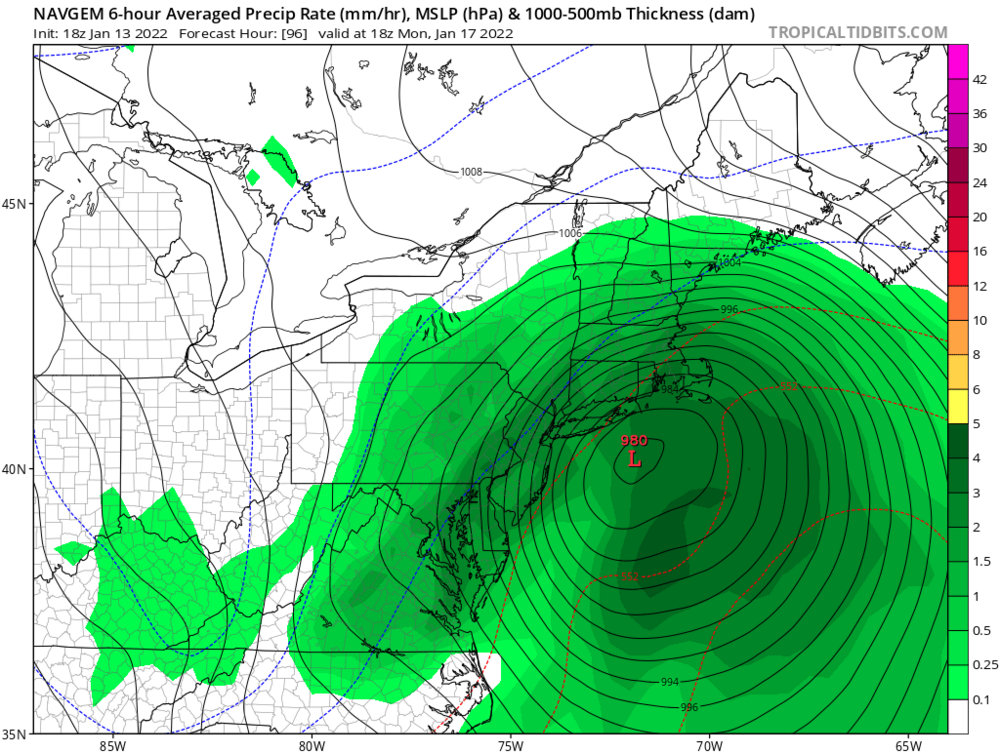
-
I agree. The next couple of weeks at least are great, Feb can be figured out later. Often times the pattern change gets delayed, and even if there is a warm spell it’s possible it only lasts like a week before the pattern goes back to a big ridge out west. It’s too early to give up on the next storm that the models are running inland never mind the rest of the winter.
-
Monitoring a potential important TV to East Coastal storm: Jan 17
George001 replied to Typhoon Tip's topic in New England
Could it be signaling stronger secondary low development after the initial low cuts to our west? -
Monitoring a potential important TV to East Coastal storm: Jan 17
George001 replied to Typhoon Tip's topic in New England
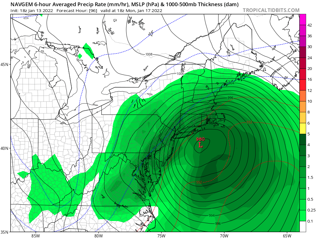
This isn’t a great look at the moment but it’s a lot better than it looked yesterday. I see 3 lows, 1 inland low 1 to the south west and most importantly, a 996 mb low to the southeast! I don’t remember seeing that yesterday, that’s exactly what I was hoping to see, as it looks like the main low running inland is all but inevitable. In my opinion this puts even eastern areas in the game for big snows even if it does eventually change over to a mix then rain. I love seeing this, it looks like the storm is evolving into a Miller B, if we can get that southern low to strengthen faster and take over quicker, this gets really interesting. We can already see that it is snowing east of the primary in central NY. The Berkshires are way east of the main low, yet it’s still snowing. That tells me the low to the southeast is already having a major influence on the rain snow line. Whether it’s all snow, rain, or a mix, this is going to be a big storm and someone, likely NW areas and areas with elevation are going to get hammered.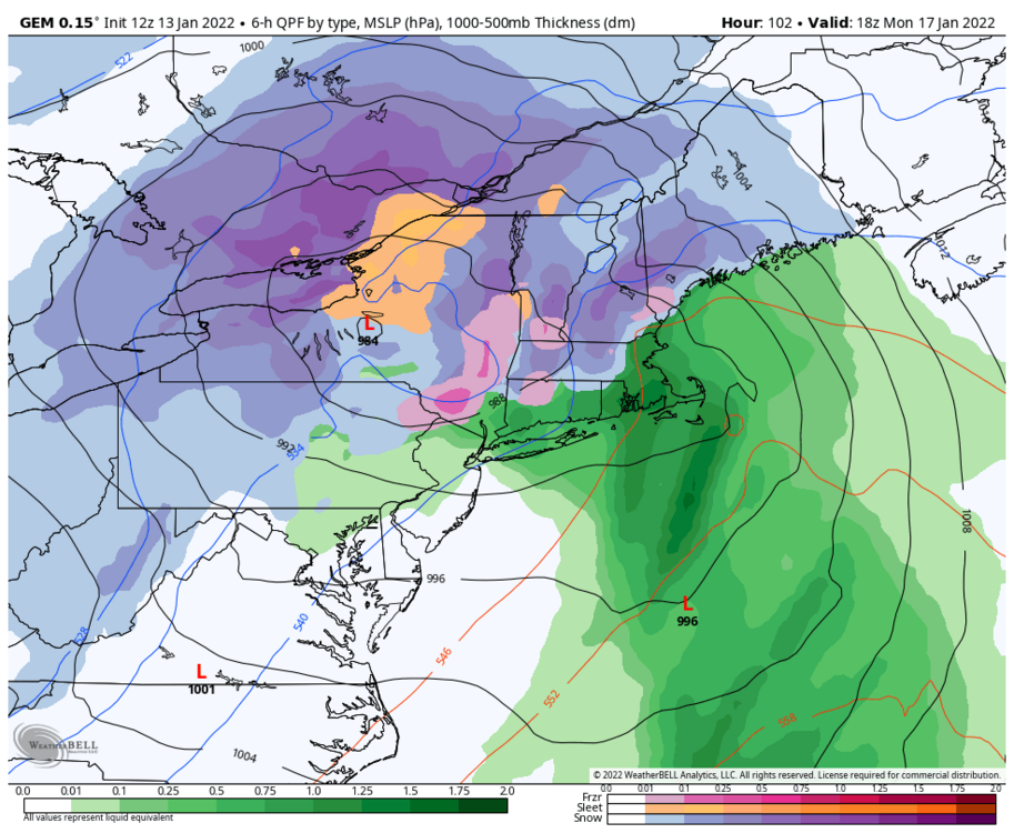
-
Monitoring a potential important TV to East Coastal storm: Jan 17
George001 replied to Typhoon Tip's topic in New England
Yeah we need large scale changes to the evolution at h5 to avoid the rain. Still far out enough where that’s possible, but the european guidance cannot be ignored. I hate seeing the only guidance with a favorable solution being the gefs. The NNE guys are in a very good spot for this if the guidance is correct, my area not so much. -
Monitoring a potential important TV to East Coastal storm: Jan 17
George001 replied to Typhoon Tip's topic in New England
I’m not a fan of what I see on the euro, it has a low way inland. If it is right about a low running inland that will make things tougher. However, due to the frigid temps before the storm this still has a lot of potential. If after initially cutting to the west, the low redevelops to the coast and turns into a Miller B, then we have something good going. Right now it’s just a Miller A and that’s not going to cut it. It wouldn’t take a ton of changes to get that low to transfer to the coast, just need the blocking to be a bit stronger. -
Monitoring a potential important TV to East Coastal storm: Jan 17
George001 replied to Typhoon Tip's topic in New England
I hope you are right, If it goes over the cape that puts interior se ma in the game for big snows as well. Even on the runs with a well inland track, for areas NW of the low even just like 5-10 miles are getting hammered with big snows. Didn’t one of the storms (I forget which one) in January 2011 have a low track over that area, and the rain snow line was confined to just NW of the canal?