
Dick_LeBoof
-
Posts
23 -
Joined
-
Last visited
Content Type
Profiles
Blogs
Forums
American Weather
Media Demo
Store
Gallery
Everything posted by Dick_LeBoof
-

Richmond Metro/Hampton Roads Area Discussion
Dick_LeBoof replied to RIC Airport's topic in Mid Atlantic
"WhY wOuLd ThE mOdEls Do ThIs To Me?!" -
Richmond Metro/Hampton Roads Area Discussion
Dick_LeBoof replied to RIC Airport's topic in Mid Atlantic
Radar is filling in that dry band now. I think the next 1.5 hours is our window. -
Richmond Metro/Hampton Roads Area Discussion
Dick_LeBoof replied to RIC Airport's topic in Mid Atlantic
Found a nifty visual showing the recent runs off the GFS/NAM/HRRR. 3 runs going back to the 06z.ForecastHourlyWeatherData.jpeg.thumb.png.df10b64458e5cf20420a286b7417038c.png)
-
Richmond Metro/Hampton Roads Area Discussion
Dick_LeBoof replied to RIC Airport's topic in Mid Atlantic
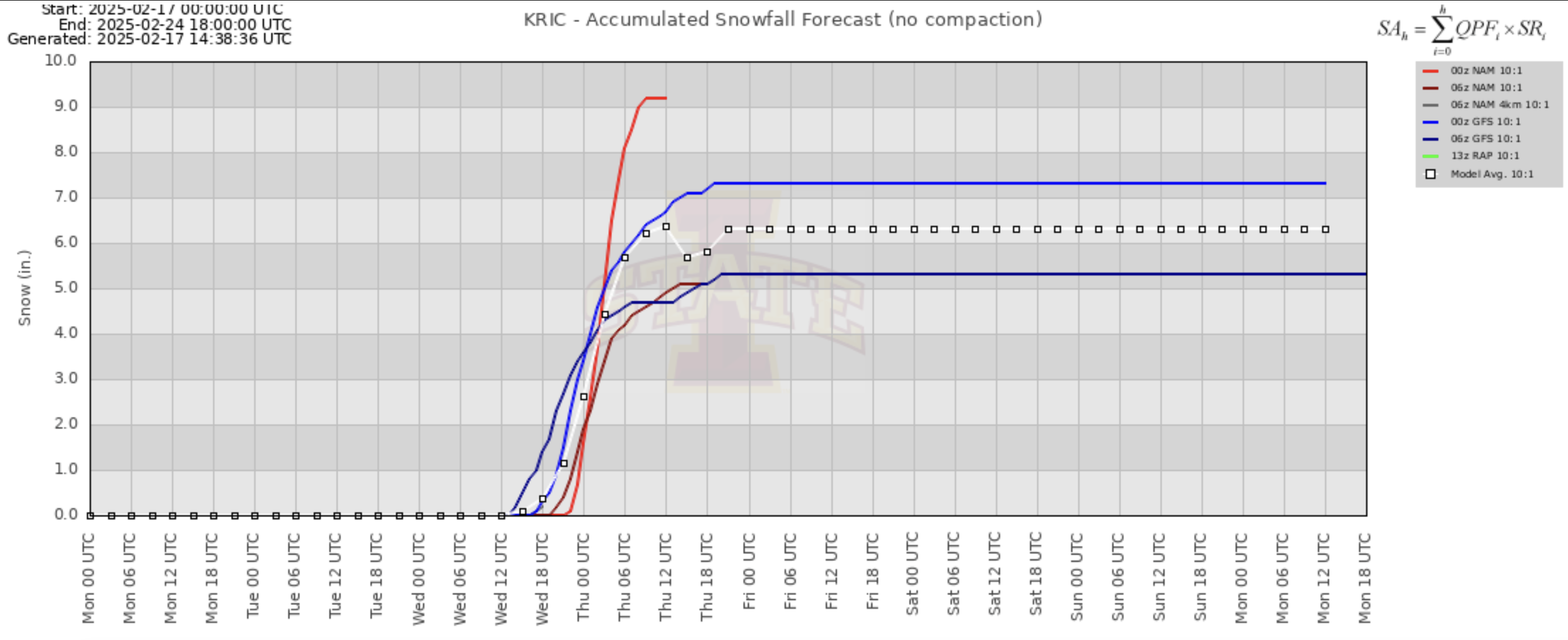
That's fair. The models have consolidated now, but it's within 12 hr of the first flakes falling. I guess I'm surprised with how much the globals swayed leading up. -
Richmond Metro/Hampton Roads Area Discussion
Dick_LeBoof replied to RIC Airport's topic in Mid Atlantic
Does anybody know the last time we had such disagreement in models this close to the event? It's been a wild ride the past 24 hours to say the least. -
Richmond Metro/Hampton Roads Area Discussion
Dick_LeBoof replied to RIC Airport's topic in Mid Atlantic
Interesting! Seems like this mostly has characteristics of a Miller-A? -
Richmond Metro/Hampton Roads Area Discussion
Dick_LeBoof replied to RIC Airport's topic in Mid Atlantic
Seems like the Euro is keeping QPFs way down? Can someone explain what drives moisture forecast for this setup? Is it how close the coastal low gets? Or related to energy from the gulf? -
Richmond Metro/Hampton Roads Area Discussion
Dick_LeBoof replied to RIC Airport's topic in Mid Atlantic
Regardless of how this storm shakes out this has been such a blast tracking. We've had it all. Models shifting south, models shifting back north, DT drama, local TV mets scrambling to adjust totals, heartbreak, and watching a meltdown in everyone's favorite mid-atlantic forum. 10/10 week. -
Richmond Metro/Hampton Roads Area Discussion
Dick_LeBoof replied to RIC Airport's topic in Mid Atlantic
I don't think I've seen the RVA news meteorologists change predictions this often! And each station has a pretty different call. -
Richmond Metro/Hampton Roads Area Discussion
Dick_LeBoof replied to RIC Airport's topic in Mid Atlantic
SREF Plumes looking healthy for KRIC.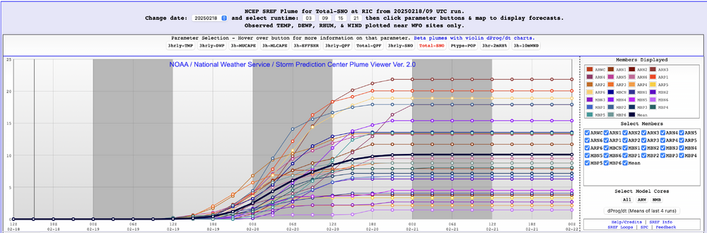
-
Richmond Metro/Hampton Roads Area Discussion
Dick_LeBoof replied to RIC Airport's topic in Mid Atlantic
The HRRR is looking so good. Quality meaty bands coming through. -
Richmond Metro/Hampton Roads Area Discussion
Dick_LeBoof replied to RIC Airport's topic in Mid Atlantic
Reading into their verbiage on the Winter Storm Watch they just issued feels very bullish for the Richmond metro! -
Richmond Metro/Hampton Roads Area Discussion
Dick_LeBoof replied to RIC Airport's topic in Mid Atlantic
Well this stinks. Going to hold my breath and watch the meso-scale models from here on out. I still feel like we have a chance with the shortwave pulling enough moisture into the forecast area and the precipitation shield spreading north as it usually does. The cold will be there. Just need to the low to move north. -
Richmond Metro/Hampton Roads Area Discussion
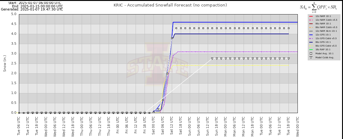
Dick_LeBoof replied to RIC Airport's topic in Mid Atlantic
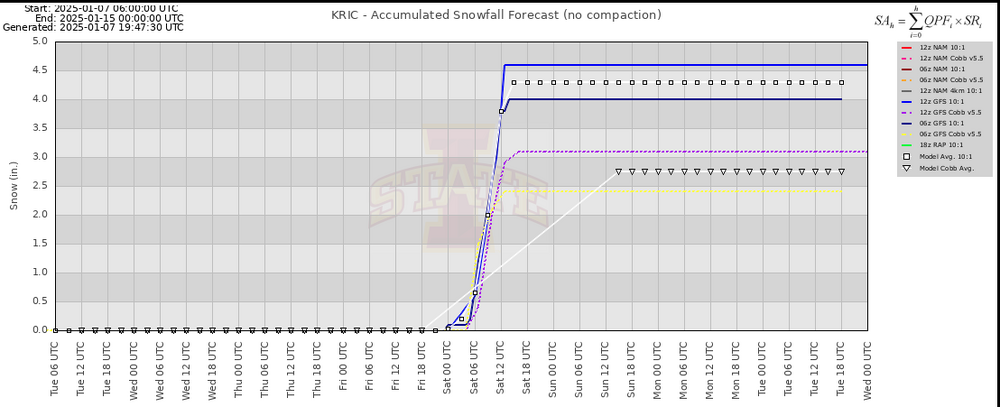
NAM looks good. Here is a meteogram showing the most recent NAM and GFS runs at KRIC. GEFS Plumes are middle of the road for this. Plenty of members showing both the north and south hits.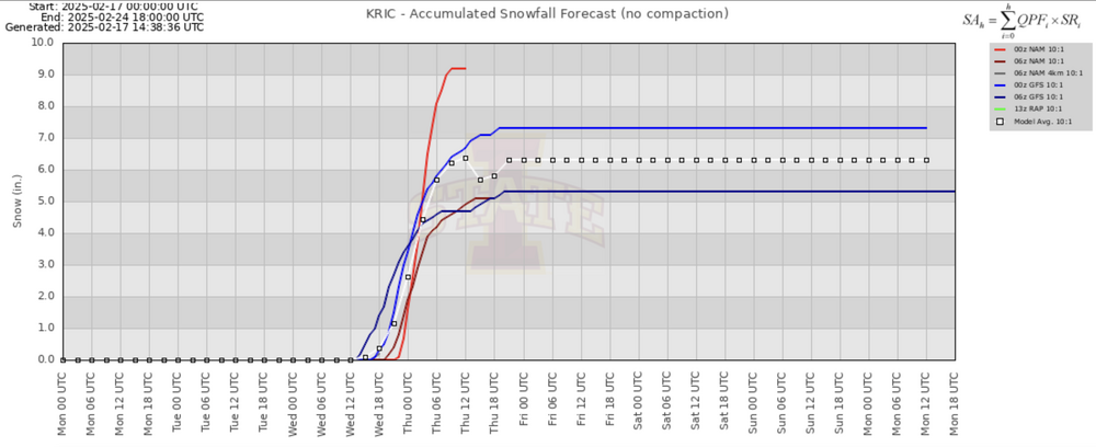
-
Richmond Metro/Hampton Roads Area Discussion
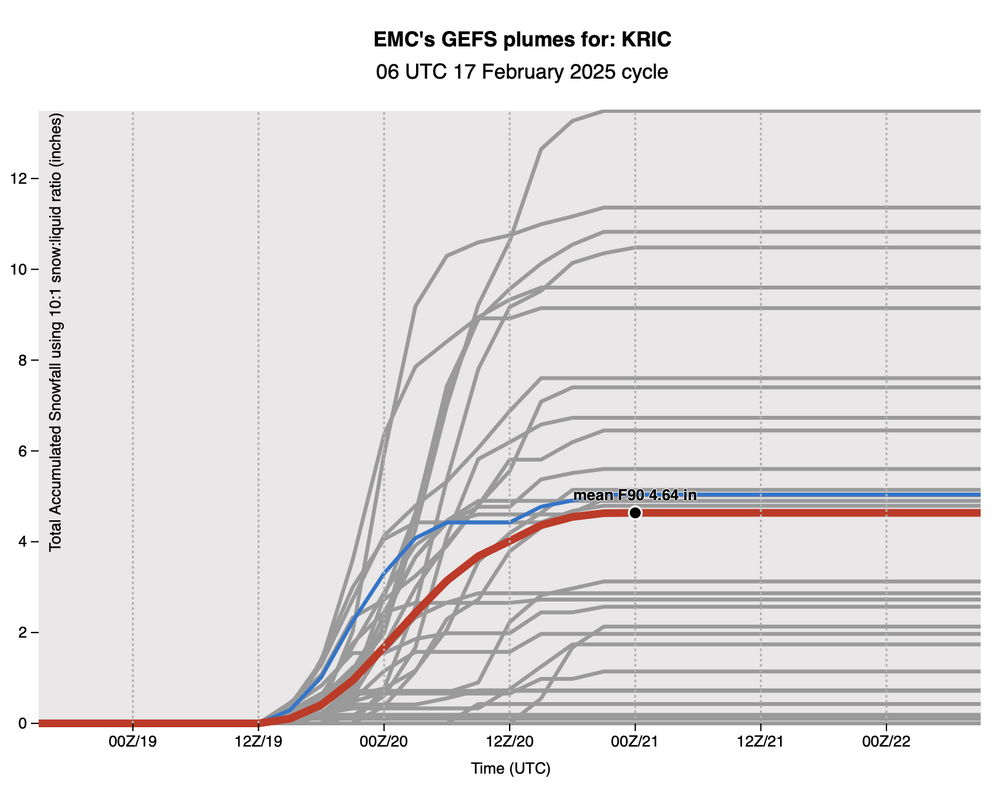
Dick_LeBoof replied to RIC Airport's topic in Mid Atlantic
Here are the GEFS plumes for Richmond. This is 10:1 Snowfall. Pretty big spread in solutions for the 06 GEFS Run. 4in seems to be a comfortable place to land with this system. As is tradition, we pray for a good banding setup in addition to this rain/snow line.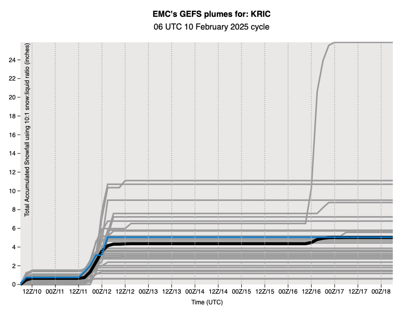
-
Richmond Metro/Hampton Roads Area Discussion
Dick_LeBoof replied to RIC Airport's topic in Mid Atlantic

-
Richmond Metro/Hampton Roads Area Discussion
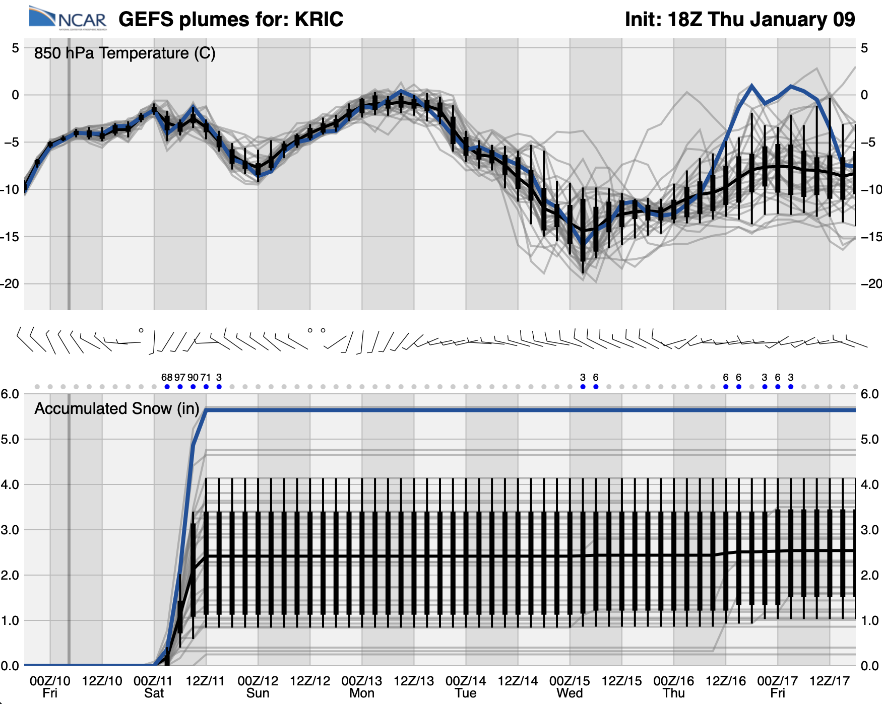
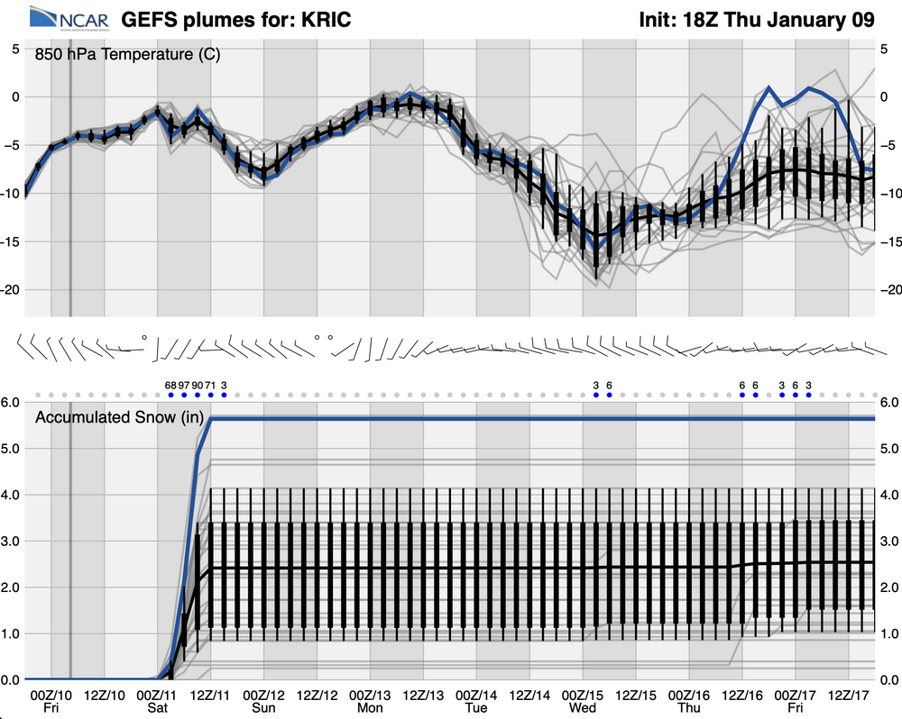
Dick_LeBoof replied to RIC Airport's topic in Mid Atlantic
18Z GEFS Ensembles giving us 5-6 and staying comfortably below 0 at 850mb for the duration of the event. You love to see it.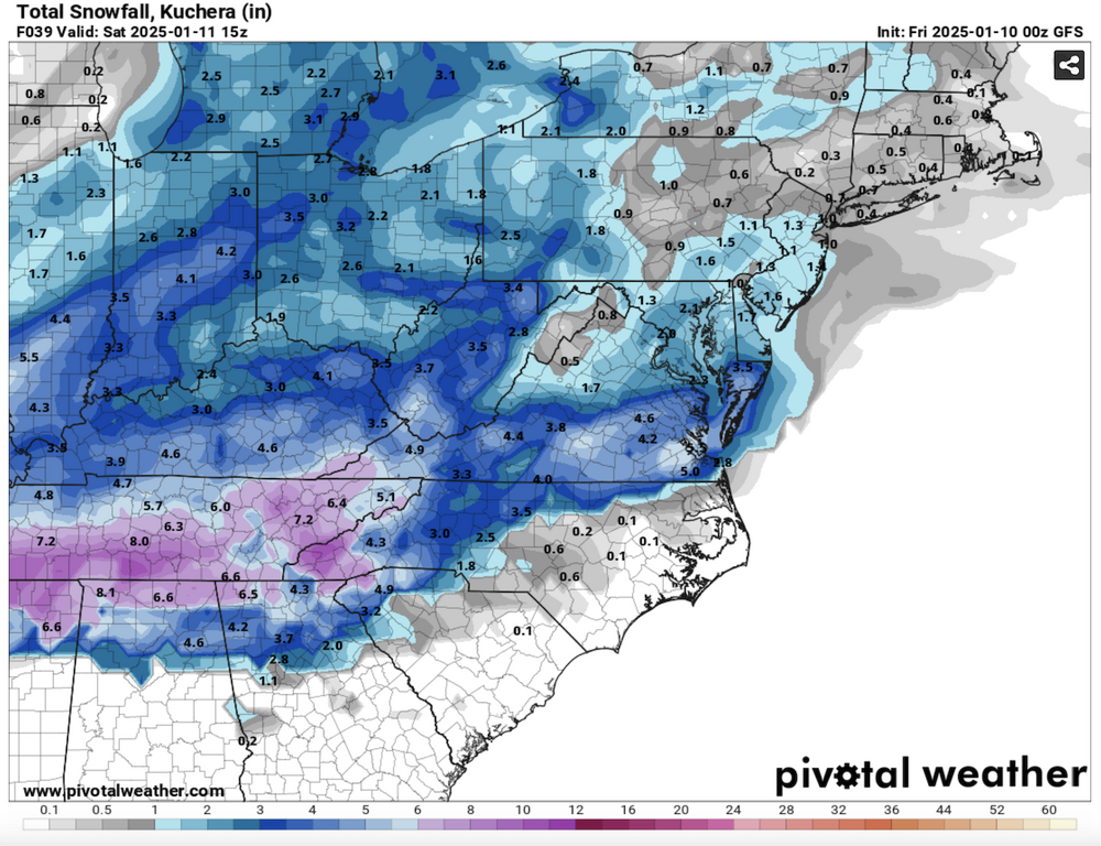
-
Richmond Metro/Hampton Roads Area Discussion
Dick_LeBoof replied to RIC Airport's topic in Mid Atlantic
I think the most recent NWS briefing summarizes the event really well. -
Richmond Metro/Hampton Roads Area Discussion
Dick_LeBoof replied to RIC Airport's topic in Mid Atlantic
That's what I'm seeing as well. Here is some data using the latest GEFS ensembles, and a meteogram with the outputs of the deterministic models plotted together.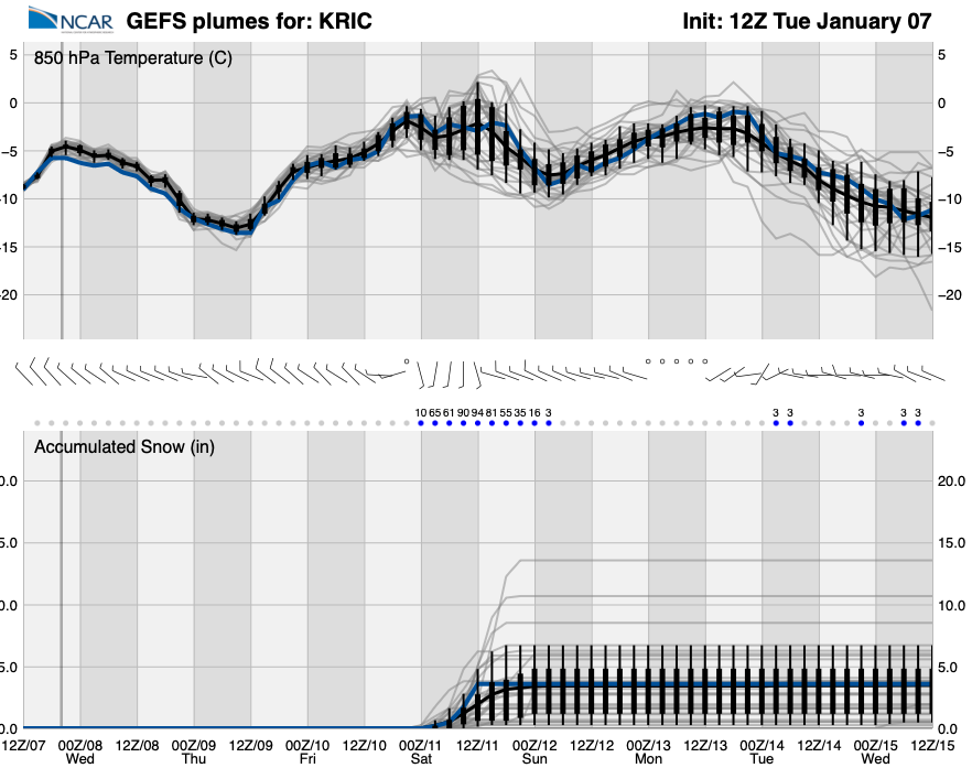
-
Richmond Metro/Hampton Roads Area Discussion
Dick_LeBoof replied to RIC Airport's topic in Mid Atlantic
12Z GFS has trended warmer than the previous 3 runs, but the moisture is certainly in the right place. I assume this would be a textbook Miller A evolution? Latest EPS ensembles have the coastal low much further off the coast than the American solution. Will be interesting to see if the models begin to converge at all. Given the arctic blast, I would be surprised to see us not have enough cold air for this event. -
Richmond Metro/Hampton Roads Area Discussion
Dick_LeBoof replied to RIC Airport's topic in Mid Atlantic
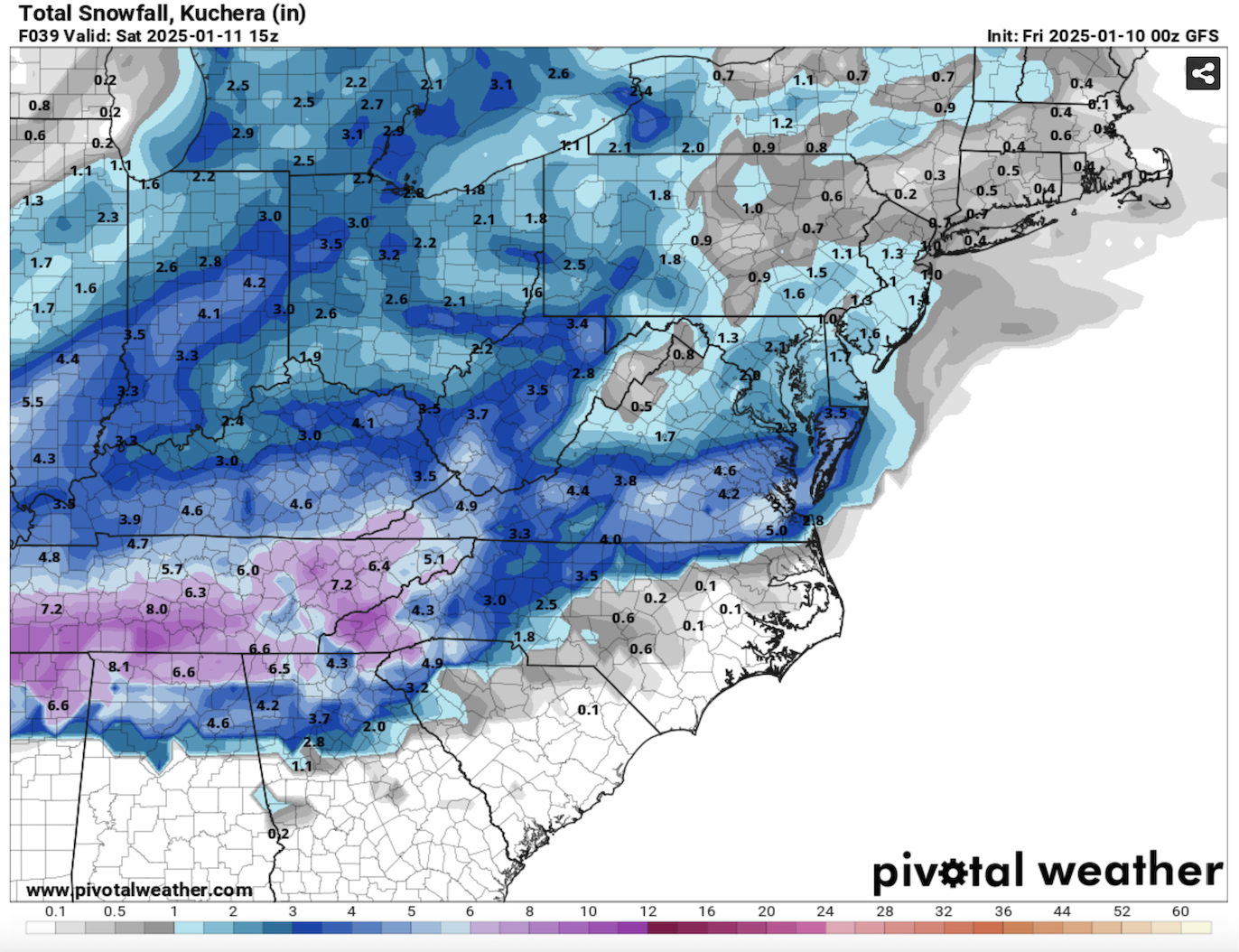
Here are the latest totals for the wrap-around deformation band from the HRRR model. Richmond metro looking at 2ish.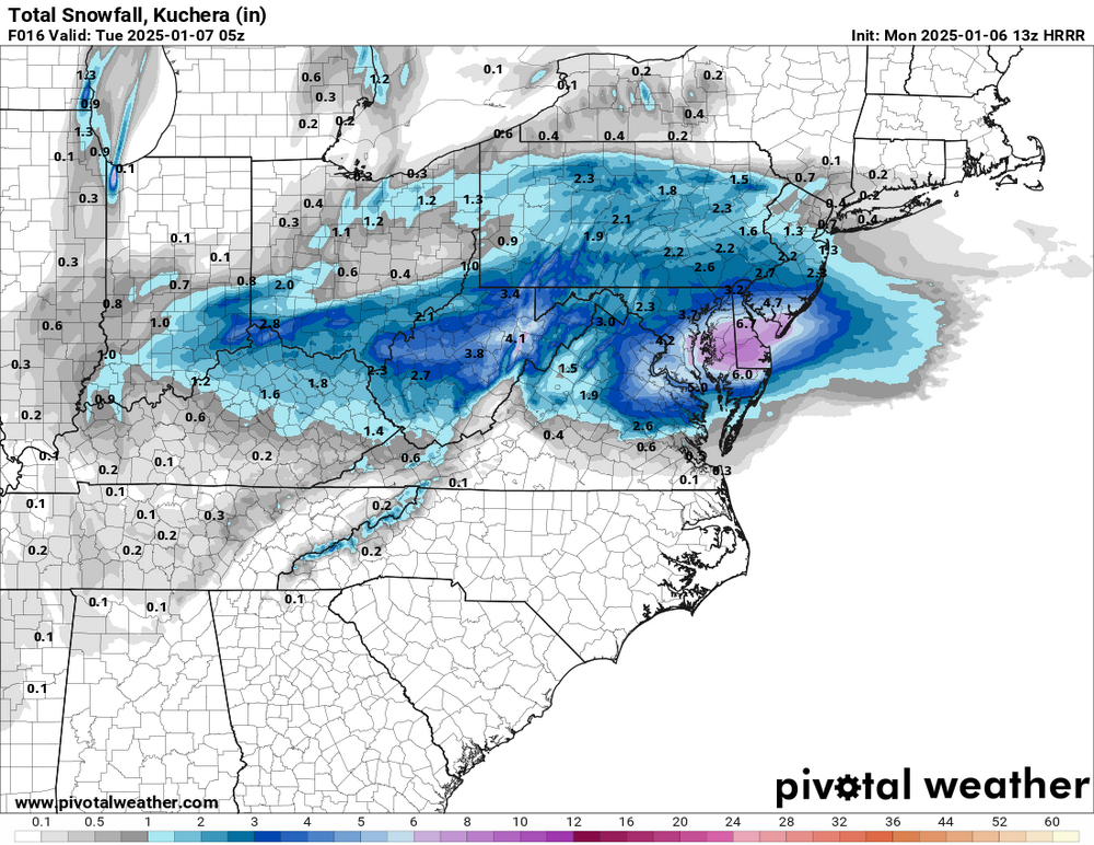
-
Richmond Metro/Hampton Roads Area Discussion
Dick_LeBoof replied to RIC Airport's topic in Mid Atlantic
Wow the precip has really filled in on radar! Much earlier than expected. Appears that the cold air has intruded further south than the modeling anticipated as well!
-
Richmond Metro/Hampton Roads Area Discussion
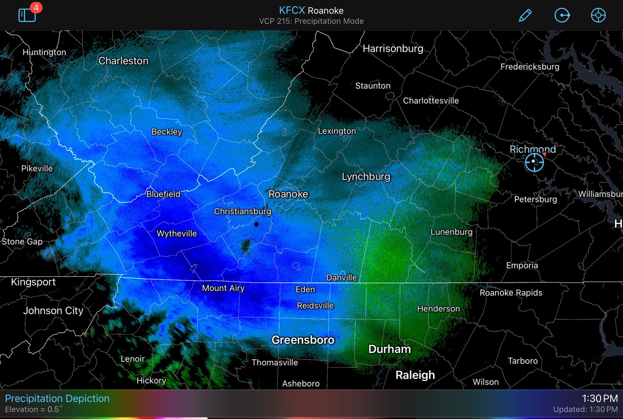
Dick_LeBoof replied to RIC Airport's topic in Mid Atlantic
Some good looking banding beginning to form now on the radar! Hopefully the column stays cold.

ForecastHourlyWeatherData.jpeg.png.385d391463eab1b126a78f325f131d1b.png)