Mount Joy Snowman
-
Posts
4,985 -
Joined
-
Last visited
Content Type
Profiles
Blogs
Forums
American Weather
Media Demo
Store
Gallery
Everything posted by Mount Joy Snowman
-

Central PA Summer 2023
Mount Joy Snowman replied to canderson's topic in Upstate New York/Pennsylvania
I think you meant to quote my other post about Ida. This post was about totals from yesterday. Sorry if that wasn't clear. -
Central PA Summer 2023
Mount Joy Snowman replied to canderson's topic in Upstate New York/Pennsylvania
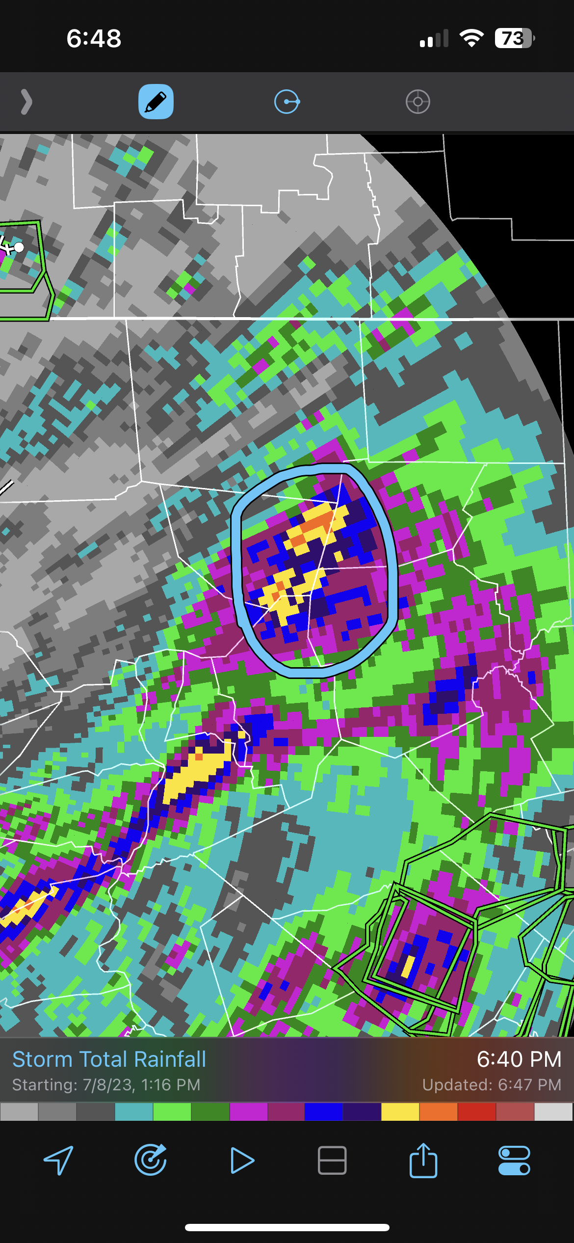
Here are the most impressive totals I could find on WU stations for yesterday's event..... 7.62 near Sinking Spring, including ~4" in one hour 6.71 west of Reading, including 1" in ten minute at one point 6.55 between Sunbury and Snydertown The highest total on Cocorahs is 6.15 near Quakertown in Bucks County. -
Central PA Summer 2023
Mount Joy Snowman replied to canderson's topic in Upstate New York/Pennsylvania
Low of 64 here. It was nice to not be hovering around 70 for the first time in a while. Looks like a pretty decent week on tap. Here is what I have in my notes about Ida @Jns2183, from which I received 5.39" of rain. *The remnants of Hurricane Ida rolled through as a tropical depression, leading to an all-day hard rain with embedded tropical downpours. 5.39" total for me with most of the area seeing 4-8". Heaviest totals of 8-10" across central/northern NJ into NYC, with some places seeing 2-4" per hour, where nighttime flash flooding led to dozens of deaths. Multiple tornadoes in southeastern PA and southern NJ as well, including an EF3 in NJ that was one of the strongest on record there. Conestoga River at Lancaster crested at third-highest level ever of 18.49', behind only Agnes and LEE. Schuylkill River at Philadelphia crested at second-highest mark ever behind only the flooding of 1869. Harrisburg recorded third highest daily rainfall ever on September 1, 2021, totaling 6.64 inches, behind only Agness and Lee. -
Central PA Summer 2023
Mount Joy Snowman replied to canderson's topic in Upstate New York/Pennsylvania
Laporte is very elevated, above 2,000’ if I recall correctly, which is one of the reasons it always does so well. Big escarpment there by Ricketts Glen state park. Beautiful area. -
Central PA Summer 2023
Mount Joy Snowman replied to canderson's topic in Upstate New York/Pennsylvania
i called it….Laporte area….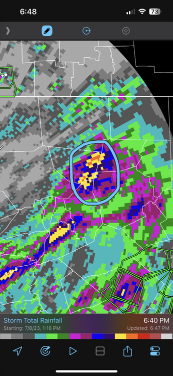
-
Central PA Summer 2023
Mount Joy Snowman replied to canderson's topic in Upstate New York/Pennsylvania
68 glorious degrees out now. Just took the kids for a walk around the neighborhood. Couldn't be more perfect. Oh, and as others have stated, I’m also on my third whiskey haha. #SundayFunday -
Central PA Summer 2023
Mount Joy Snowman replied to canderson's topic in Upstate New York/Pennsylvania
Final tally here of 1.8”. Seems like the perfect amount. All grass and shrubbery is happy. -
Central PA Summer 2023
Mount Joy Snowman replied to canderson's topic in Upstate New York/Pennsylvania
Have surged well past an inch here with the upstream radar looking diabolical. -
Central PA Summer 2023
Mount Joy Snowman replied to canderson's topic in Upstate New York/Pennsylvania
Checking in from West Hempfield. We finally got in on the action here. Got absolutely mauled to the tune of almost 3/4” in like 15 mins. Gonna be a wild ride! -
Central PA Summer 2023
Mount Joy Snowman replied to canderson's topic in Upstate New York/Pennsylvania
Same. I was stunned by how many there were when I mowed. -
Central PA Summer 2023
Mount Joy Snowman replied to canderson's topic in Upstate New York/Pennsylvania
Everything mostly nice and green here. That half inch yesterday really helped and tomorrow will surely secure things for a little while longer. All in all not bad for July considering what we were looking at not long ago. -
Central PA Summer 2023
Mount Joy Snowman replied to canderson's topic in Upstate New York/Pennsylvania
Love it. Let’s have some fun tomorrow. Any bets on who gets the most? I’m gonna treat it like winter and go with Laporte haha. -
Central PA Summer 2023
Mount Joy Snowman replied to canderson's topic in Upstate New York/Pennsylvania
Rule #1 of weather: there is always someone worse off than you. Rule #2 is everyone thinks their area gets screwed the most. Come to think of it, I guess those are pretty much one and the same haha. -
Central PA Summer 2023
Mount Joy Snowman replied to canderson's topic in Upstate New York/Pennsylvania
Haha I saw that and thought enough is enough already. Mercy. -
Central PA Summer 2023
Mount Joy Snowman replied to canderson's topic in Upstate New York/Pennsylvania
Ugh you were royally screwed today. The Harrisburg peeps, I mean what more can be said. They have been crushing it lately. -
Central PA Summer 2023
Mount Joy Snowman replied to canderson's topic in Upstate New York/Pennsylvania
Been surreal watching the radar over Harrisburg. Hopefully some of it can hold together for @Itstrainingtime -
Central PA Summer 2023
Mount Joy Snowman replied to canderson's topic in Upstate New York/Pennsylvania
Latest HRRR is still insistent on popping another line over us around the 6-7 time period. We shall see. -
Central PA Summer 2023
Mount Joy Snowman replied to canderson's topic in Upstate New York/Pennsylvania
It was hilarious watching that tiny cell over me not move for like 45 minutes but believe it or not it wasn't overly heavy; just a nice drenching rain to the tune of .5". Round one in the books. -
Central PA Summer 2023
Mount Joy Snowman replied to canderson's topic in Upstate New York/Pennsylvania
Well, one of those little cells is just hovering right over me so there go my plans to mow over lunch today. Still, thankful for the win. -
Central PA Summer 2023
Mount Joy Snowman replied to canderson's topic in Upstate New York/Pennsylvania
The humidity is ungodly today. My DP is 73 and I'm currently surrounded by storms. -
Central PA Summer 2023
Mount Joy Snowman replied to canderson's topic in Upstate New York/Pennsylvania
Haha, if only. I don't play lottery, of any type. What can I say, my stats brain just won't let me ha. -
Central PA Summer 2023
Mount Joy Snowman replied to canderson's topic in Upstate New York/Pennsylvania
Good morning my fine friends of American Weather. If it please the members, I'm going to take a moment to briefly toot my own horn. 10 days ago, I predicted June would end with an average temp of 70.3 at MDT, and well, June ended with an average temp of 70.3. Yes, I know there were only five days left in the month at that point but it still takes some gusto to nail the daily averages to that degree, and yes, a good bit of luck is required as well ha. But congrats to me! And thank you all for indulging in my numbers-based hubris National high/low of 116 at Stovepipe Wells, CA and 29 near Big Piney, WY. Carry on. -
Central PA Summer 2023
Mount Joy Snowman replied to canderson's topic in Upstate New York/Pennsylvania
So who all felt the massive propane explosion at the Rapho Township Municipal building this morning ~6am? It shook my whole house. Can't imagine what it was like for the people who live within a mile radius. Thankfully no injuries as of yet but I could see the smoke plume on the way to the train. Tons of crews reporting from all over. Crazy. -
Central PA Summer 2023
Mount Joy Snowman replied to canderson's topic in Upstate New York/Pennsylvania
I also got suuuuuuuuper high in Talkeetna haha. But mine was from some “hash-ade” I purchased at the local pot shop. Highly recommend. -
Central PA Summer 2023
Mount Joy Snowman replied to canderson's topic in Upstate New York/Pennsylvania
I saw and heard it but virtually nothing fell here. Only added an additional .01” for a total of .39”. You win.