Mount Joy Snowman
-
Posts
3,803 -
Joined
-
Last visited
Content Type
Profiles
Blogs
Forums
American Weather
Media Demo
Store
Gallery
Everything posted by Mount Joy Snowman
-

Central PA - Winter 2021/2022
Mount Joy Snowman replied to Bubbler86's topic in Upstate New York/Pennsylvania
Ukie holds with the coastal idea...... -
Central PA - Winter 2021/2022
Mount Joy Snowman replied to Bubbler86's topic in Upstate New York/Pennsylvania
You bite your tongue! -
Central PA - Winter 2021/2022
Mount Joy Snowman replied to Bubbler86's topic in Upstate New York/Pennsylvania
Exactly, you can see slow but steady improvement. Apologies to our western PA friends for my use of the word "improvement" ha. As always, theses things are relative. -
Central PA - Winter 2021/2022
Mount Joy Snowman replied to Bubbler86's topic in Upstate New York/Pennsylvania
QPF for the storm, heaviest snow west of 11/15...... -
Central PA - Winter 2021/2022
Mount Joy Snowman replied to Bubbler86's topic in Upstate New York/Pennsylvania
GFS still wants to plow straight north through central PA. I for one am not buying it, but it is a player on the field at this point. -
Central PA - Winter 2021/2022
Mount Joy Snowman replied to Bubbler86's topic in Upstate New York/Pennsylvania
Super clean panel here ha..... -
Central PA - Winter 2021/2022
Mount Joy Snowman replied to Bubbler86's topic in Upstate New York/Pennsylvania
National low yesterday was -25 at Knowls Corner, Maine. I only mention because it's relatively rare for it to come from anywhere other than the high-elevation west, and when it does happen in the northeast it's typically Mt. Washington. -
Central PA - Winter 2021/2022
Mount Joy Snowman replied to Bubbler86's topic in Upstate New York/Pennsylvania
Not claiming superior knowledge to you haha but I would say yes that's a distinct possibility, with the stronger system producing more powerful mid-level winds off the ocean and thus increasing the probability of warm layers capable of producing sleet. There are many caveats to this but short answer is yes it could have that effect here. However, I'd still prefer to roll the dice with a wound-up crusher. -
Central PA - Winter 2021/2022
Mount Joy Snowman replied to Bubbler86's topic in Upstate New York/Pennsylvania
Been studying the 0z suite. I like the evolution that is being shown on the Euro/Ukie, as well as various ensembles, for a more traditional Delmarva to Long Island type coastal storm. While a storm moving due north through central PA wouldn't be unprecedented, it would certainly be unusual. I think we'll see the models converge on the coastal solution, with your classic heavy totals across central and northeastern PA and some mixing issue across southeastern PA. A lot of time left in the game but this outcome makes the most sense to me. As for the pattern at-large, man do we have some nice cold and snow to play with over the coming weeks -- coastals, clippers, lake-effect machine, and everything in between. Let's have some fun with it, as patterns like this only come around so often. Winter has arrived boys and girls, now let's do the damn thang! -
Central PA - Winter 2021/2022
Mount Joy Snowman replied to Bubbler86's topic in Upstate New York/Pennsylvania
I topped out at 23 today. Currently at 15 with a DP of 3. Interesting days ahead it would seem. -
Central PA - Winter 2021/2022
Mount Joy Snowman replied to Bubbler86's topic in Upstate New York/Pennsylvania
Looks like the big winner on The Tug was 30" near Osceola. -
Central PA - Winter 2021/2022
Mount Joy Snowman replied to Bubbler86's topic in Upstate New York/Pennsylvania
I dropped to 14, not aware of any such snow shower here. I stayed up for the national championship game and didn't notice anything, and certainly no evidence of anything this morning. Good for you for "cashing in" haha. Looks to be a lot of cold air around in the weeks to come. Now we've just got to thread the needle with the storms, but I'll take the cold air in place and let the chips fall where they may. -
Central PA - Winter 2021/2022
Mount Joy Snowman replied to Bubbler86's topic in Upstate New York/Pennsylvania
A thing of beauty….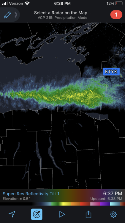
-
Central PA - Winter 2021/2022
Mount Joy Snowman replied to Bubbler86's topic in Upstate New York/Pennsylvania
Yeah I think they have a legit shot against Tampa, not great but legit. The Bucs are a bit of a mess right now and I don't believe are the same team as last year. I would however note that since losing to the Giants the Eagles have beaten the Jets, Giants, and Redskins twice. Soooooo, kind of hard to know what to make of that haha. But they are certainly a live dog this weekend! -
Central PA - Winter 2021/2022
Mount Joy Snowman replied to Bubbler86's topic in Upstate New York/Pennsylvania
This is likely accurate, reality check incoming haha. But that's why they play the games! -
Central PA - Winter 2021/2022
Mount Joy Snowman replied to Bubbler86's topic in Upstate New York/Pennsylvania
Yep, something to be said about that level of consistency. Big Ben never presided over a season with a losing record, and he has a career 13-9 postseason record. This Packers fan can respect that. I think they are in for a beating at KC next weekend but there's nothing I would love more than to see one last bit of magic. -
Central PA - Winter 2021/2022
Mount Joy Snowman replied to Bubbler86's topic in Upstate New York/Pennsylvania
How about it!? I honestly couldn't believe some of what I was witnessing yesterday. What a day, and how the heck are both the Eagles and the Steelers in the playoffs?? Both teams loving that new 7th playoff spot haha. -
Central PA - Winter 2021/2022
Mount Joy Snowman replied to Bubbler86's topic in Upstate New York/Pennsylvania
Yeah it appears we were scoured out quickly around these parts. -
Central PA - Winter 2021/2022
Mount Joy Snowman replied to Bubbler86's topic in Upstate New York/Pennsylvania
A decent batch of precip has been rolling through here and it’s primarily just plain rain. The ever so slightest ice accretions on certain surfaces but not much to speak of. Temp up to 33. Was expecting low level cold to hang on a bit more, should be in the clear down this way. -
Central PA - Winter 2021/2022
Mount Joy Snowman replied to Bubbler86's topic in Upstate New York/Pennsylvania
Temp already at 32 here this morning, was not expecting that. I assume we’ll drop back down a bit if some precip moves through but all in all not seeing many big issues down this way. -
Central PA - Winter 2021/2022
Mount Joy Snowman replied to Bubbler86's topic in Upstate New York/Pennsylvania
I topped out at 28 today. Shaded areas still have a nice full pack. -
Central PA - Winter 2021/2022
Mount Joy Snowman replied to Bubbler86's topic in Upstate New York/Pennsylvania
Haha yes my thoughts exactly! Perhaps I’ll send them a strongly worded tweet -
Central PA - Winter 2021/2022
Mount Joy Snowman replied to Bubbler86's topic in Upstate New York/Pennsylvania
I’m not sure that’s a damn good question and was really what caught my attention. Seems like they should be on, no?? -
Central PA - Winter 2021/2022
Mount Joy Snowman replied to Bubbler86's topic in Upstate New York/Pennsylvania
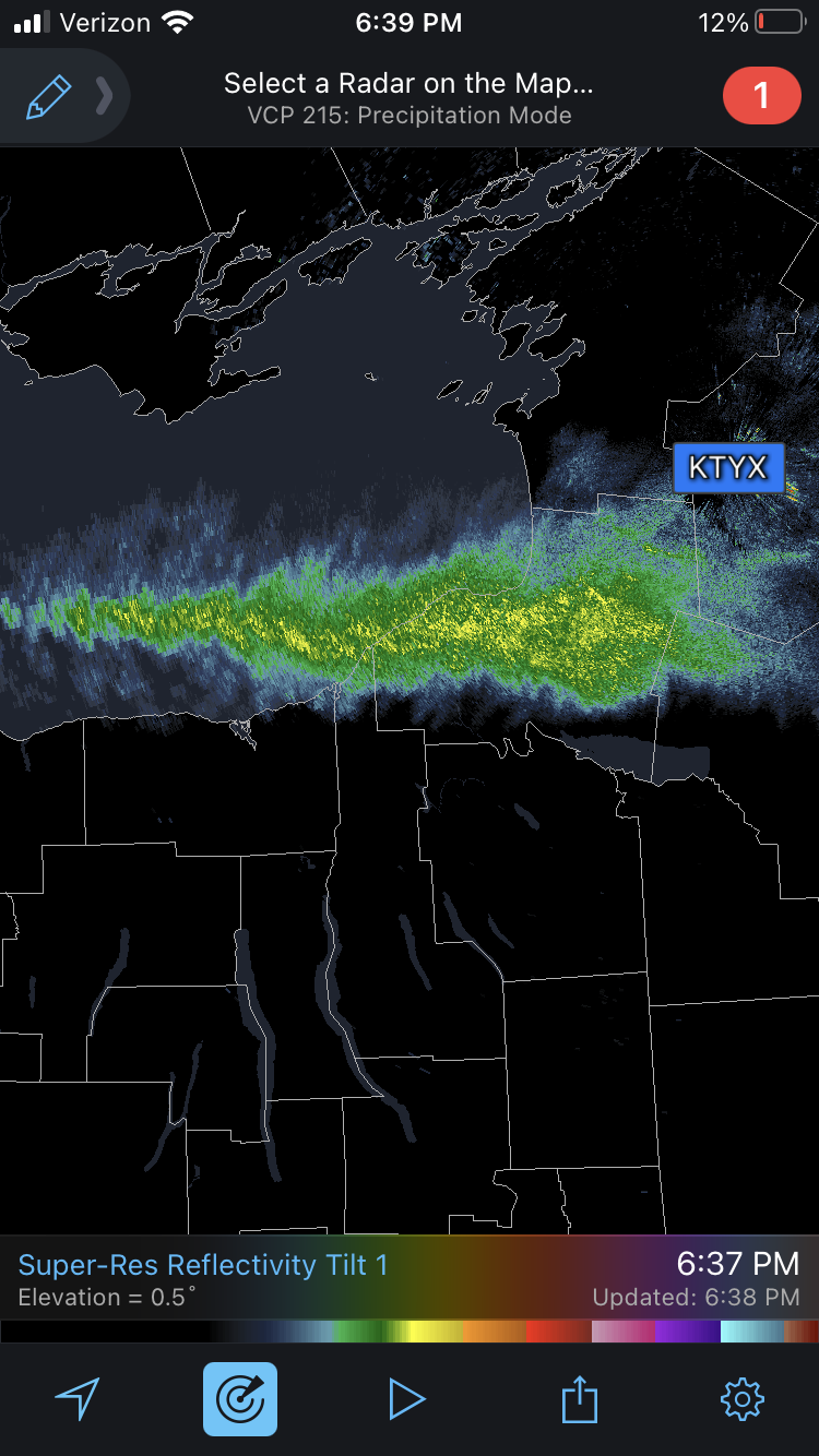
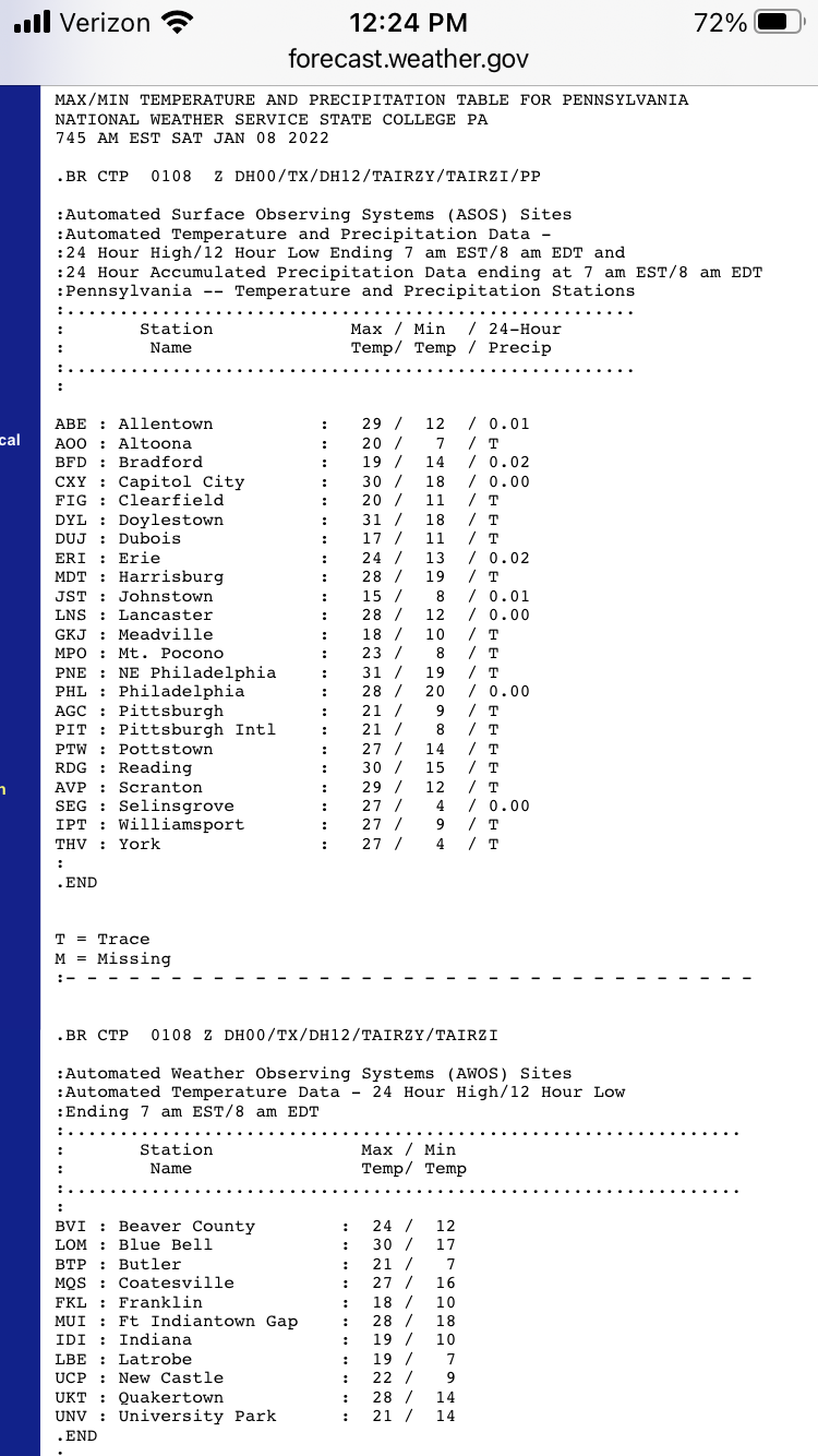
Oh nice thank you for that. I was just going off the roundup of the ASOS/AWOS sites that is released twice a day (see below). I wonder why AFJ isn’t included in that? Is AFJ a notorious cold spot? Relative low elevation spot?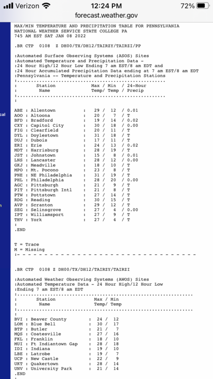
-
Central PA - Winter 2021/2022
Mount Joy Snowman replied to Bubbler86's topic in Upstate New York/Pennsylvania
I see the notorious radiational cooling spots of THV and SEG both dropped to 4 last night, much colder than any other official stations in the state.