

Mount Joy Snowman
-
Posts
3,804 -
Joined
-
Last visited
Content Type
Profiles
Blogs
Forums
American Weather
Media Demo
Store
Gallery
Everything posted by Mount Joy Snowman
-

Central PA - Winter 2021/2022
Mount Joy Snowman replied to Bubbler86's topic in Upstate New York/Pennsylvania
We are all weeneis on this Thursday morning. Let's bring her home! -
Central PA - Winter 2021/2022
Mount Joy Snowman replied to Bubbler86's topic in Upstate New York/Pennsylvania
Showing off my low-lying cold here as I dropped to 24 last night, same as THV. Incredibly thick fog this morning (ice fog no less), couldn't even remotely see the Amishman's barn less than 1/8 mile away. Remarkably, it fully burned off by like 9am. Waiting for the precip from yesterday to fully melt but looks like I should come in somewhere around .6". My way-too-early thoughts for LSV Saturday......I think we wake up to a period of heavy rain, followed by a quick transition to a cold wind-driven snow and temperatures plummeting through the 20s throughout the day. Flash freeze in full effect. I'm thinking something like 1-3" for the LSV, 3-6" for the middle parts of the valley, and 6-12" for western and northern tier areas. As others have mentioned, always tricky having the cold chase the precip in these scenarios but this one looks to have real potential, and the needle seems to want to thread just right with the two pieces of energy. I think it was @losetoa6 who mentioned the HRRR doing well lately and I couldn't agree more. I used to ignore that model beyond like 12-18 hours out but it's done a really nice job of picking up on the finer details even at range lately. The 12z HRRR sure looks like it's about to be a flush hit and the 12z NAM just came in very strong as well. This could be the real deal for the forum. In any event, I think we're looking at one heck of a dynamic day of weather with some damaging winds, brutal cold, multiple precip types, and hopefully meaningful accumulating snow for mostly everyone. All aboard! -
Central PA - Winter 2021/2022
Mount Joy Snowman replied to Bubbler86's topic in Upstate New York/Pennsylvania
You know you've been chasing the Black Knights for years -
Central PA - Winter 2021/2022
Mount Joy Snowman replied to Bubbler86's topic in Upstate New York/Pennsylvania
Yes yes my mistake Penn Manor. Solanco is even more vast and unknown to most Lancastrians haha. Good stuff, loving your tales of southern living. -
Central PA - Winter 2021/2022
Mount Joy Snowman replied to Bubbler86's topic in Upstate New York/Pennsylvania
Good stuff. Solanco school district is huge with a varied climate. I recall many times where they'd have delays and no other districts would. They just cover such a vast swath of hilly terrain. You are right most don't realize what it can be like down there. -
Central PA - Winter 2021/2022
Mount Joy Snowman replied to Bubbler86's topic in Upstate New York/Pennsylvania
CTP's PNS says it all for down this way, doesn't even include totals for any counties southeast of Snyder County. On to Saturday. -
Central PA - Winter 2021/2022
Mount Joy Snowman replied to Bubbler86's topic in Upstate New York/Pennsylvania
Haha that's awesome, small world. As I've told you before, my buddy has a cabin up by Gaines and we've always used these cams to check conditions. We don't ride but still like to keep an eye on what's going on up there. You can take pride in knowing your site is used by more than just people in the club. Great work Nut! -
Central PA - Winter 2021/2022
Mount Joy Snowman replied to Bubbler86's topic in Upstate New York/Pennsylvania
This one by chance? I usually use the links off the PA Grand Canyon Snowmobile Club. Sweeden Hill.......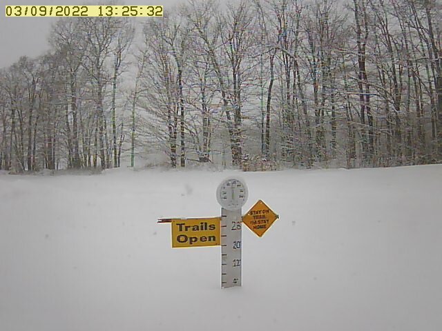
-
Central PA - Winter 2021/2022
Mount Joy Snowman replied to Bubbler86's topic in Upstate New York/Pennsylvania
You don't by chance use mPING do you? Northern tier really cashing in with this. Near Cherry Springs......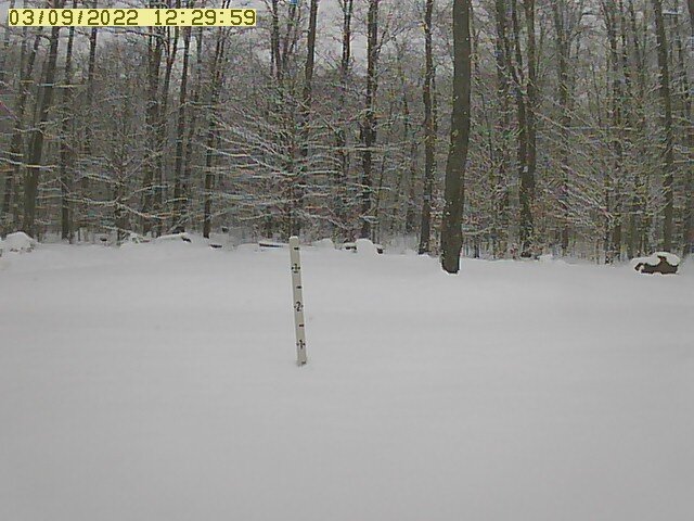
-
Central PA - Winter 2021/2022
Mount Joy Snowman replied to Bubbler86's topic in Upstate New York/Pennsylvania
Well said and agreed. Honestly, I think the simple answer is that it just wasn't our year around these parts. Couldn't thread the needle. I know that's the easy out, but there was snow to be found all around us and ample cold at various times. Just wasn't meant to be. In the eternal motto of the weather fan, there's always next year! -
Central PA - Winter 2021/2022
Mount Joy Snowman replied to Bubbler86's topic in Upstate New York/Pennsylvania
Snow has shut off here and switched over to a mix of light sleet and rain. Temp never dropped below 35. All white on the ground will be disappearing in short order. .1" officially going in the books for this event, which, despite the low expectations, still has to be considered a mild bust around here. -
Central PA - Winter 2021/2022
Mount Joy Snowman replied to Bubbler86's topic in Upstate New York/Pennsylvania
Can report back that, sure enough, there is at least a solid inch on the ground on top of Chickies at ~700', whereas I only have a trace down here in the lowlands. Snowing a little harder with a lower temp as well, as expected. The top of the cell tower was very obscured. Nothing on the basketball court but believe it or not the little side road leading up to the park was caving, enough that I even slid a little coming down it ha. Well, that is my most exhilarating and likely final winter moment for this season. It's a sad life I lead.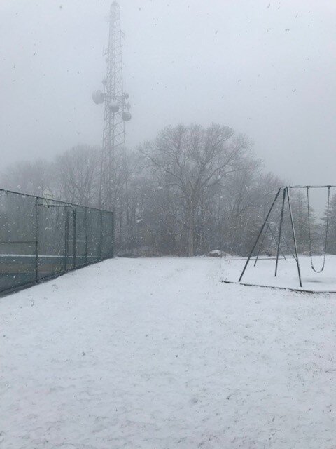
-
Central PA - Winter 2021/2022
Mount Joy Snowman replied to Bubbler86's topic in Upstate New York/Pennsylvania
Peakbagger is a great site. No I haven't been to that exact spot, which is right near the point where Lancaster, Lebanon and Berks Counties all meet, but I have been to some other high spots up in the Furnace Hills. A buddy and I once backpack camped up there on a high hill then hiked down to fish for opening day trout (believe it was Hammer Creek). We were probably at ~1,000 feet. Beautiful area up that way, as @GrandmasterB knows all too well. -
Central PA - Winter 2021/2022
Mount Joy Snowman replied to Bubbler86's topic in Upstate New York/Pennsylvania
Not sure I've ever seen a more elevation dependent map from CTP, and I think they have the right of it. -
Central PA - Winter 2021/2022
Mount Joy Snowman replied to Bubbler86's topic in Upstate New York/Pennsylvania
Good stuff. Yeah I'm going to drive to the little park less than a mile to the south of me in about an hour to see if anything has stuck up there. It's one of the higher spots along Chickies Ridge, sitting at ~700'. -
Central PA - Winter 2021/2022
Mount Joy Snowman replied to Bubbler86's topic in Upstate New York/Pennsylvania
Sitting at 36 here and despite a good 20 minutes now of heavy wet snow nothing is able to stick to any surfaces. Wet ground and warm temps just won't allow for it around here. As @Itstrainingtime mentioned, Lancaster County really is the battleground with varying conditions all around the county. But bottom line is minimal to no accumulation will be the result. Heck, not even my north facing mulch bed is taking it on. -
Central PA - Winter 2021/2022
Mount Joy Snowman replied to Bubbler86's topic in Upstate New York/Pennsylvania
I’m sitting at 36/27 with rain just now starting to show some signs of transitioning to a wet snow, barely. Looking forward to a nice mid morning thump of white rain but otherwise expect minimal impact here. Keeping the O/U at one inch on non-paved surfaces. -
Central PA - Winter 2021/2022
Mount Joy Snowman replied to Bubbler86's topic in Upstate New York/Pennsylvania
How many times have we seen it? All aboard, train's heading north! Aaaaaahhhhh up above Brickerville are ya? Love it up that way. Yeah you will fare a good bit better than me I reckon. -
Central PA - Winter 2021/2022
Mount Joy Snowman replied to Bubbler86's topic in Upstate New York/Pennsylvania
It really does feel like the last hurrah. Fingers crossed. -
Central PA - Winter 2021/2022
Mount Joy Snowman replied to Bubbler86's topic in Upstate New York/Pennsylvania
Harrisburg's record snowfall for March 12 is 4.1" in 1959. Can we get there!? -
Central PA - Winter 2021/2022
Mount Joy Snowman replied to Bubbler86's topic in Upstate New York/Pennsylvania
An interesting quirk on the 12z GFS for tomorrow morning's event......even when the graphic panels are showing snow for my area (moderate to heavy at times), when you check the skew-T's for the same timestamps it lists likely precip type as rain. Not sure what to make of that. -
Central PA - Winter 2021/2022
Mount Joy Snowman replied to Bubbler86's topic in Upstate New York/Pennsylvania
Yeah I'm heading up to the state wrestling championships in Hershey on Saturday morning and was telling the guys when we go into the Giant Center there could be a warm rain falling and when we come out a few hours later there could be a cold wind-driven snow ha. Again, March. -
Central PA - Winter 2021/2022
Mount Joy Snowman replied to Bubbler86's topic in Upstate New York/Pennsylvania
The FV3 seems to be picking up on the temp issues down this way and the snow map responds accordingly, similar to the HRRR....... -
Central PA - Winter 2021/2022
Mount Joy Snowman replied to Bubbler86's topic in Upstate New York/Pennsylvania
.08" of rain yesterday with a low of 37, currently at 39. Looks like LNS recorded a 59mph gust with the frontal passage. As for tomorrow morning's snow chances down this way, I'm growing more pessimistic by the hour. Temperature issues abound. The lower levels of the column aren't all that cold and the surface temps are downright problematic. As I said yesterday, dew points at or above freezing don't exactly scream efficient accumulation haha. This is to say nothing of daytime solar effects and lighter intensity periods. Ratios will likely be abysmal. MAG went over most of this yesterday, but for us in the southern reaches of the LSV the issues are mounting. Elevation will be key and I ain't got it. Going with an O/U of 1" for my back yard. As always, I hope to be wrong. Good luck to all but keep expectations in check. Toodles. -
Central PA - Winter 2021/2022
Mount Joy Snowman replied to Bubbler86's topic in Upstate New York/Pennsylvania
Not much rain here but some serious gusts. It’s really roaring outside, front means business. Had some friends record gusts near 50mph on home stations. Very impressive.


