WolfStock1
Members-
Posts
157 -
Joined
-
Last visited
About WolfStock1

Profile Information
-
Four Letter Airport Code For Weather Obs (Such as KDCA)
LEE
-
Location:
Leesburg, VA
Recent Profile Visitors
The recent visitors block is disabled and is not being shown to other users.
-
Occasional Thoughts on Climate Change
WolfStock1 replied to donsutherland1's topic in Climate Change
Weather vs climate. If a football team is down 50-0 and then scores a touchdown - you can't really say that they've turned it around and are suddenly the better team. -
Best wishes! Good you were able to get into the hospital OK. You'll have quite the memorable story. Hope the birth goes well.
-
LCPS now closed. Coming down pretty good.
-
Gotta figure many places will cancel. LoCo is on 2-hour delay but said "stay tuned". Based on history I bet they'll cancel. Haven't looked at the roads yet but there's lots on the ground and it's snowing now, and it's cold enough the roads won't melt easy.
-
Occasional Thoughts on Climate Change
WolfStock1 replied to donsutherland1's topic in Climate Change
Thought this bit was kind of odd: "The revised analysis shows economic damages from climate change till mid-century are substantial and outweigh the costs of mitigation" It seems the relationship of the costs shouldn't necessarily be 1:1 or anything like that. Every dollar spent on mitigation doesn't lessen the costs of CC by a dollar - it may be much less or it may be much more; and you may actually want one or the other. E.g. say the costs due to CC (generally storms - wind and flooding) end up being $500 billion in a given area over the next 25 years, if no mitigation was done. You could spend say twice that - say $1 trillion - on sea walls, stricter building codes, river flood mitigation (drainage and walls), and lessen the resulting damage costs from $500B to say $300B. Was it bad to spend the $1 trillion, since the net loss is $700B? Maybe, but maybe not if you consider that there are also lives involved; presumably less lives lost in the do-mitigate case. Looking from a strictly financial standpoint - it seems like you generally would *want* your mitigation costs to be less than the damage costs, right? This is due to the unpredictable nature of storms. If you spend more money to mitigate then the delta between the two is by definition wasted money - generally. That said - there's probably some low-hanging fruit that is worthwhile. E.g. the US built a series of flood-control dams after the big Ohio river flood in 1937; this likely ended up saving money in the long run, so that might be a case where the cost of mitigation reduced the likely cost of non-mitigation damages. Same is true for flood walls in various places - usually it's money well spent. But it's rarely a 1:1 tradeoff though; so comparing the two sets of figures seems odd. -
Occasional Thoughts on Climate Change
WolfStock1 replied to donsutherland1's topic in Climate Change
A pretty devastating article in WSJ today on the negative effects of the renewable energy push on the European economy: https://www.wsj.com/business/energy-oil/europes-green-energy-rush-slashed-emissionsand-crippled-the-economy-e65a1a07 While the existence of warming is undeniable (e.g. see new record low Arctic ice extent in other thread), this illustrates how hard of a problem this is to solve. -
Indeed - seems a bit misleading to present a subset of the data (the area around Canada) and discuss it as if it was the full set (the Arctic). That's the kind of thing that causes finger-pointing.
-
Occasional Thoughts on Climate Change
WolfStock1 replied to donsutherland1's topic in Climate Change
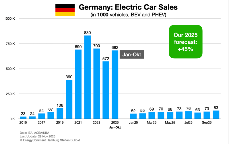
Import duties on Chinese EVs are irrelevant - they are not legal to drive in the US. Electricity prices in the US are amongst the lowest in the world, so it's not that. https://www.statista.com/statistics/263492/electricity-prices-in-selected-countries/?srsltid=AfmBOoqfk-WgVGYRIpGDuUwvfazUcrDxpPwXNEyFvUDUiI8qOR-Dq7J8 China does indeed have lower electricity prices; with many factors including that allowing them to have continued growth in EV sales (though it appears to be slowing there some as well). Amongst that is that they don't have as much low-hanging fruit of fossil as we do (oil), extremely low wages (about 1/3 of US), and a regime that generally doesn't care about environmental or social conditions; instead with a "build at all costs" policy. Do we really want that in the US? Germany is probably a good example of policy gone bad, with their aggressive push towards solar and wind. This has resulted in extremely high electricity prices, and stalled EV sales (though there appears to be an uptick this year at least). Gemany generally has about 2.8M car sales per year, so they've topped out at roughly 30% being electric. They've picked the low-hanging fruit. Keep in mind that these to-date numbers are in a policy regime where EV sales have been heavily subsidized. (that includes China BTW) -
Occasional Thoughts on Climate Change
WolfStock1 replied to donsutherland1's topic in Climate Change
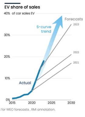
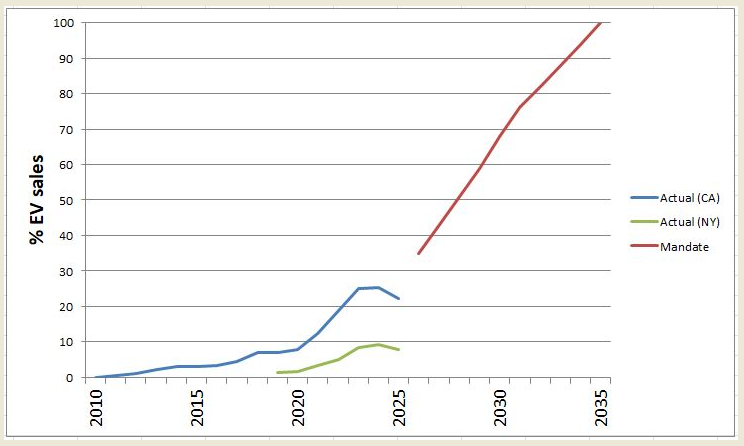
One thing I often talk about is "low hanging fruit". It depends on the technology, but very often trend bias applies when predicting future growth (the same thing that often happens with stocks, BTW). Looking at EV sales as example: Note that that prediction was made in what appears to be 2022 or 2023. However here is what has actually happened after that (in the two largest states, which have online dashboards with mandates): After the low-hanging fruit (rich people with easily-accessible charging at home or work) buying a second car was picked - sales are now falling - not continuing the upwards trend predicted. Same is true for solar and wind electricity generation. Note where all the larger solar and wind farms are - it's a lot easier to be less expensive when you install them in the easy low-hanging-fruit places to supply local electricity. Not so much when you need to feed the entire grid. -
Occasional Thoughts on Climate Change
WolfStock1 replied to donsutherland1's topic in Climate Change
Wow. Just wow. I have news for you - I used to live in South Florida, and visited Miami regularly, and I have family that live on the west coast in Florida and still visit there regularly. It's nothing like you characterize. The primary source of flooding we generally saw was due to occasional heavy rains - not some kind of creeping ocean. You're quite the drama queen. You know nothing about the interactions of cities and oceans. Is there sometimes flooding from hurricanes? Yes there can be (I was there during Andrew). But it's always been the case - it's nothing new, and it's nothing horribly destructive and regular as you present. I'm quite sure that *you* do not and have not lived in such a place. If it was so bad - why do you think so much construction is going on there? Wouldn't people be moving *away* from there, instead *into* Miami (and Florida overall)? Miami's population has increased over 20% just in the last 20 years. I guess those people must be dolphins or something. I realize the NFL team is the dolphins - but I'm pretty sure the people that live there aren't *actually* dolphins. -
Occasional Thoughts on Climate Change
WolfStock1 replied to donsutherland1's topic in Climate Change
Miami being "under water" in 2075 or 2125 is the kind of absurdly-hyperbolic alarmism that I allude to in my other post. Sea levels have risen about 6 inches in a century, and you're proposing that Miami might be "under water" going forward in less than that time? Seriously? Can't you see how ludicrous this is? And no - the costs aren't the same. Infrastructure generally turns over every few decades or so. Miami as a whole is only 125 years old, and didn't really exist anywhere close to its current form until after WW2 70-80 years ago. Having it be destroyed over the course of say 30-50 years would be *way* more expensive than having it be destroyed over the course of say 300 years, because over the course of 300 years it would essentially be replaced anyhow (without any sea level rise) due to natural aging and replacement. Sea-level-induced replacement (inland and/or higher) would essentially be free. This discussion assumes, obviously incorrectly, that Miami wouldn't attempt to remediate via sea walls and the like. Even simply raising up the land and building new islands is not that hard - just look at the UAE. Regarding sources - IMO a research organization presenting a raft of sourced facts and figures is a lot more credible than some random poster on a message board. -
Occasional Thoughts on Climate Change
WolfStock1 replied to donsutherland1's topic in Climate Change
Stepping back - I would like to say, believe it or not, that I'm not anti-renewable-energy, by any stretch. It will eventually be inevitable and necessary, and will be a good thing in the long run. I'm being devil's advocate here because I see a big sales job being done - some would say a con job even - in overstating the progress of renewables, and in understating the downside costs of the big renewable push, in terms of the hit it's causing on the prosperity of our society. The migration to renewable is going to take a long time - likely well over a hundred years IMO if not two hundred, and it's going to cause significant and unavoidable pain. We have been in a golden age of easy energy with fossil fuels, and it will end. Fossil is simply easier than renewables, because of physics - primarily energy density; with us living within a few hundred years period reaping the benefits of millions of years of natural storage and compaction of energy into tiny masses of burnable stuff. It will eventually be gone, with us having to transition to renewables. (Short the other alternative which is extinction or at least near-extinction of humans) In pushing the transition to renewables as hard as we are we are though - before the transition would otherwise happen organically, we are only serving to increase that transition pain. And I'm talking net pain; after any benefit to slowing MMGW (which IMO is negligible) is included in the equation. -
Occasional Thoughts on Climate Change
WolfStock1 replied to donsutherland1's topic in Climate Change
Actually no - they're not Specifically a key benefit to fossil that is not achieved from renewables is baseline reliability. This is of course huge, and a complete deal-breaker when it comes to trying to use renewables for the lion's share of our energy sources, for the foreseeable future. As it is now renewables can only act as a supplement to the primary energy sources of fossil, nuclear, and to a small extent hydro. Renewables cannot act as a primary source without completely redundant systems (a deal breaker cost-wise) or huge growth in battery storage (also a deal-breaker for the foreseeable future). Somehow this keeps getting ignored/forgotten about. It's moving its way towards center stage though, as our electrical grid becomes increasingly unreliable, and our EV sales growth sputters as it has. The demand growth due to AI certainly isn't helping the situation - it is certainly pushing the issue more to the center of the stage. Add to that the scale factor. So far renewables have mostly been picking the low-hanging fruit - with power being supplied to the grid in areas where wind and solar are easy - the desert southwest for solar and the flyover country for wind. Trying to scale wind and solar from its current 15% of electrical supply in those regions to the 75-80% or so required nationwide (particularly in the harder-to-reach NE population corridor), and adding the increased demand due to EVs and AI is going to require incredible growth in our electrical grid infrastructure. The benefits-vs-cost equation starts to change dramatically after the low-hanging fruit has been picked. -
Occasional Thoughts on Climate Change
WolfStock1 replied to donsutherland1's topic in Climate Change
Nope. Read the links I posted for actual numbers. As of 2022 renewable energy comprised 53 percent of all energy subsidies. This includes tax incentives. And this despite renewables only being 21% of production. https://www.instituteforenergyresearch.org/fossil-fuels/renewable-energy-still-dominates-energy-subsidies-in-fy-2022/ The "when all financial factors are included" thing throws a bunch of subjective factors in that allow the author to twist the numbers to meet their agenda (like including "costs" in the equation for fossil fuel but not including the benefits). -
Occasional Thoughts on Climate Change
WolfStock1 replied to donsutherland1's topic in Climate Change
Bingo. chubbs and donaldsutherland1 don't seem to understand that "subsidies" and "costs" are not the same thing. You can't just lump them in together like that. If you're going to do that - you also have to include "benefits". Not doing so simply invalidates the argument. It's an attempt to distract from the actual argument, which is explicit subsidies. That is a valid discussion, and the data clearly shows that renewable energy receives far more subsidies than fossil-fuel energy.


