

TimB
-
Posts
16,576 -
Joined
Content Type
Profiles
Blogs
Forums
American Weather
Media Demo
Store
Gallery
Everything posted by TimB
-

Pittsburgh, Pa Winter 2023-24 Thread.
TimB replied to meatwad's topic in Upstate New York/Pennsylvania
I’m liking the way this is trending. Advisory level event on most to all guidance at the moment. -
Pittsburgh, Pa Winter 2023-24 Thread.
TimB replied to meatwad's topic in Upstate New York/Pennsylvania
Where do I sign for the 12z HRRR?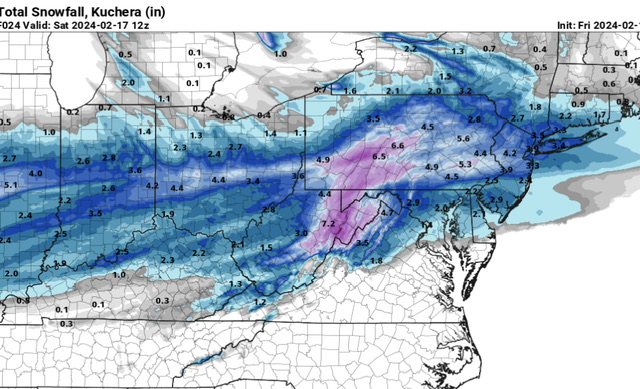
-
Pittsburgh/Western PA Banter & Complaint Thread
TimB replied to blackngoldrules's topic in Upstate New York/Pennsylvania
Not going to clog up the snow thread, but it’s funny that PIT apparently gusted to 60 at 6:33pm and then a wind advisory was issued 14 minutes later. -
Pittsburgh, Pa Winter 2023-24 Thread.
TimB replied to meatwad's topic in Upstate New York/Pennsylvania
NAM looked fine too. -
Pittsburgh, Pa Winter 2023-24 Thread.
TimB replied to meatwad's topic in Upstate New York/Pennsylvania
HRRR improved again at 0z. Now up to a 2-3” type event. -
Pittsburgh, Pa Winter 2023-24 Thread.
TimB replied to meatwad's topic in Upstate New York/Pennsylvania
18z HRRR was a significant improvement over 12z. -
Pittsburgh/Western PA Banter & Complaint Thread
TimB replied to blackngoldrules's topic in Upstate New York/Pennsylvania
That’s fine, we still have 95-96 to replace in the normals. -
Pittsburgh, Pa Winter 2023-24 Thread.
TimB replied to meatwad's topic in Upstate New York/Pennsylvania
-
Pittsburgh, Pa Winter 2023-24 Thread.
TimB replied to meatwad's topic in Upstate New York/Pennsylvania
With PIT sitting at 11.6 for the season, that’s a steep climb. -
Pittsburgh, Pa Winter 2023-24 Thread.
TimB replied to meatwad's topic in Upstate New York/Pennsylvania
One chance at meaningful snowfall in 2 years! Hope it somehow works out for us. -
Pittsburgh/Western PA Banter & Complaint Thread
TimB replied to blackngoldrules's topic in Upstate New York/Pennsylvania
And that’s what it boils down to. A top 5 futility season would be a lot easier to stomach if we didn’t have something eerily similar last year, in a totally different ENSO base state. Could I be less invested in this hobby? Of course, we all could. But even if I weren’t obsessively watching models or looking at stats showing historic winter warmth or lack of snow, these seasons have been bad enough that even the casuals have to be aware that these past two winters have been epically bad. -
Pittsburgh, Pa Winter 2023-24 Thread.
TimB replied to meatwad's topic in Upstate New York/Pennsylvania
Miss south, next weekend’s storm cuts, another ridge after that, curtains. -
Pittsburgh, Pa Winter 2023-24 Thread.
TimB replied to meatwad's topic in Upstate New York/Pennsylvania
It’s not going to be an advisory type event. At best it’s the 1-2 type thing you mention. I take that back, there are still a few models like the RGEM that want this to be a low end advisory thing. -
Pittsburgh/Western PA Banter & Complaint Thread
TimB replied to blackngoldrules's topic in Upstate New York/Pennsylvania
We have a long way to go if we have any hope of getting out of the worst 20 or even 10 snowfall seasons. Ignoring the fact that 14 of these top 20 seasons were observed at a different site, we’re looking at 3 of the 5 worst seasons at PIT occurring in the past 5 years unless we get another 10” of snow between now and the end of the season. Still need 5” to even prevent this from being the worst in modern history.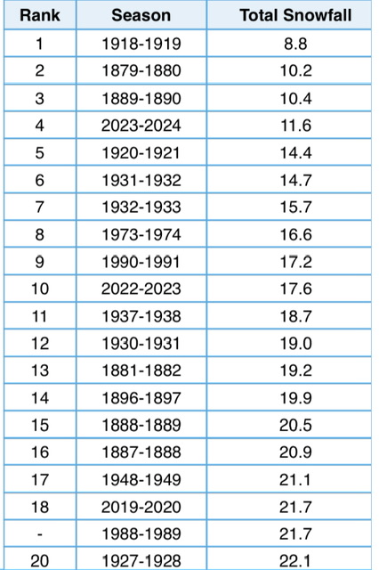
-
It’s gone. The secret was that there was never going to be an extended cold stretch because those don’t exist anymore.
-
There is not a single location on this list that is at or above normal to date. Pretty sad.
-
Pittsburgh, Pa Winter 2023-24 Thread.
TimB replied to meatwad's topic in Upstate New York/Pennsylvania
The problem with the weekend storm is there’s not model agreement at this point that the storm will even happen, let alone what areas it would hit, and we’re getting awfully close to the point where that matters. -
Pittsburgh, Pa Winter 2023-24 Thread.
TimB replied to meatwad's topic in Upstate New York/Pennsylvania
We’ll know very soon if the GFS moves away from cutter. -
Pittsburgh, Pa Winter 2023-24 Thread.
TimB replied to meatwad's topic in Upstate New York/Pennsylvania
I’m not. Same range of possibilities as the current storm at similar range. -
Pittsburgh, Pa Winter 2023-24 Thread.
TimB replied to meatwad's topic in Upstate New York/Pennsylvania
Probably. Also, we will be hitting the middle of the month with 0.01” of precip so far at PIT, which is a record for the first half of February. Previous record for that time period was 0.07”. -
Pittsburgh/Western PA Banter & Complaint Thread
TimB replied to blackngoldrules's topic in Upstate New York/Pennsylvania
On the GFS yeah. The others have suppressed garbage sliding harmlessly south. Unless you count the 0z ICON. It showed a direct hit of warning type snow. Point being there’s still hope for a middle ground solution where it snows here, but I’m just tired of watching models with no results. -
Pittsburgh/Western PA Banter & Complaint Thread
TimB replied to blackngoldrules's topic in Upstate New York/Pennsylvania
And if we’re looking to long-term snow averages at the end of the decade, we’ll already be replacing the 72.1 of 1992-93 with the 17.6 of 2022-23, and now we might be replacing the 76.8 of 1993-94 with like 12-15” in 2023-24. So that’s like a 4” drop in the calculated normals in and of itself, even if the rest of the decade is similar to its 90s counterparts. -
Pittsburgh/Western PA Banter & Complaint Thread
TimB replied to blackngoldrules's topic in Upstate New York/Pennsylvania
It’d almost be better if those elitist NYC fucks didn’t get a win out of this storm while we suffered through two snowless winters in a row. -
Pittsburgh/Western PA Banter & Complaint Thread
TimB replied to blackngoldrules's topic in Upstate New York/Pennsylvania
Afraid so. After a cold and dry weekend, a ridge next week looks very likely, then maybe another trough, then another ridge on the ensembles toward the end of their run and by then it’s a day away from March. This absolutely fucking blows. I can’t believe we had the two worst winters back to back. -
Pittsburgh, Pa Winter 2023-24 Thread.
TimB replied to meatwad's topic in Upstate New York/Pennsylvania
Not a drop of precip. Impressive really. Looks like there were even periods of clear skies observed at PIT through the night.


