
wx_observer
-
Posts
192 -
Joined
-
Last visited
Content Type
Profiles
Blogs
Forums
American Weather
Media Demo
Store
Gallery
Everything posted by wx_observer
-

OBS/DISCO - The Historic James Blizzard of 2022
wx_observer replied to TalcottWx's topic in New England
If it is any consolation, I was thinking this too. I feel like I saw way more snow fall than what verified on the ground. -
OBS/DISCO - The Historic James Blizzard of 2022
wx_observer replied to TalcottWx's topic in New England
That band threading the needle between 495 and 290 is picking up intensity…looks like the most potent band over land right now -
OBS/DISCO - The Historic James Blizzard of 2022
wx_observer replied to TalcottWx's topic in New England
This storm may have underwhelmed to the west, but with pics like that…it’s an epic storm regardless. -
OBS/DISCO - The Historic James Blizzard of 2022
wx_observer replied to TalcottWx's topic in New England
I’m a bit northwest, near Holden…Worcester has its fair share of near vertical hills for sure -
OBS/DISCO - The Historic James Blizzard of 2022
wx_observer replied to TalcottWx's topic in New England
I’m not far from green hill…same thing here. Bigger flakes, low visibility, but less wind. The flakes are finally falling more vertical than horizontal. -
OBS/DISCO - The Historic James Blizzard of 2022
wx_observer replied to TalcottWx's topic in New England
If it’s gusts at least 35 mph each hour, Worcester would verify between 7:54 am - 3:54 pm. (Airport) https://w1.weather.gov/data/obhistory/KORH.html -
OBS/DISCO - The Historic James Blizzard of 2022
wx_observer replied to TalcottWx's topic in New England
Do gusts count, or does it need to be 35 mph sustained winds to meet blizzard criteria? -
OBS/DISCO - The Historic James Blizzard of 2022
wx_observer replied to TalcottWx's topic in New England
Riddle me this—why reduce the speeds on the turnpike from NY border to Framingham, but not east of there? Seems like the worst weather is east of there. -
OBS/DISCO - The Historic James Blizzard of 2022
wx_observer replied to TalcottWx's topic in New England
Radar is looking better in central ma—it looks like that gap between the bands just west of Worcester and at 495 is filling in. -
OBS/DISCO - The Historic James Blizzard of 2022
wx_observer replied to TalcottWx's topic in New England
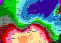
Not sure if this was already posted—but 1:17 pm update still not backing down on totals
-
This is a pretty neat sat image…for both the double low, and the rippling of clouds between them. Will be interesting to see how that area evolves in the next few hours.
-
OBS/DISCO - The Historic James Blizzard of 2022
wx_observer replied to TalcottWx's topic in New England
ORH right on the edge of one of those heavier bands—winds are picking up ahead of it. Hopefully keeps westward pivot! -
OBS/DISCO - The Historic James Blizzard of 2022
wx_observer replied to TalcottWx's topic in New England
Same in Worcester. I just went to the garage and had bare ground to 6” within a few steps of each other. -
OBS/DISCO - The Historic James Blizzard of 2022
wx_observer replied to TalcottWx's topic in New England
Not seeing updated maps yet from BOX. Sounds like they pushed higher totals further west though. -
OBS/DISCO - The Historic James Blizzard of 2022
wx_observer replied to TalcottWx's topic in New England
Super-fine powder in Worcester…about an inch so far. I was really hoping to wake up to that orangey looking night sky that happens when the light pollution from the city illuminates the clouds during storms like this, but no dice so far. Nice band showing up on radar backing in towards I-90 / I-395. Hopefully we can now collectively move past the angst of model rollercoasters and sit back and enjoy what looks to be a satisfying storm for most of the region! A few weeks ago most of us would have been giddy at 6“ Happy blizzard day! -
A pretty impressive drift happens on the other side of my fence in the neighbors yard during these potent nor’easters. It goes from bare ground near their house, to nearly 6’ high at the fence. Hope to see it again tomorrow—it’s a definitive sign of a 5 star snowstorm.
-
That’s about as strongly worded as I’ve seen in a forecast discussion
-
Even that area north of the warning is looking pretty feisty near Norwalk and heading towards Bridgeport. No warning there yet though.
-
Was watching this cell south of Stamford...just got TOR warning
-
That's some unusually clean floodwater at the airport...
-
Crazy, how this just lit up over NYC in the last few frames
-
Worcester just had positive samples for West Nile too
-
Mixing in with some whiffs of green near Temple now...
-
Is the tornado threat largely ahead of the main rain band--or within it too?
-
Severe Weather Statement National Weather Service Boston/Norton MA 1207 PM EDT Mon Aug 23 2021 MAC017-027-231630- /O.CON.KBOX.TO.W.0005.000000T0000Z-210823T1630Z/ Worcester MA-Middlesex MA- 1207 PM EDT Mon Aug 23 2021 ...A TORNADO WARNING REMAINS IN EFFECT UNTIL 1230 PM EDT FOR EAST CENTRAL WORCESTER AND CENTRAL MIDDLESEX COUNTIES... At 1206 PM EDT, a confirmed tornado was located over Berlin, or near Marlborough, moving north at 15 mph. This storm has had a history of producing a brief tornado and could continue to produce brief tornadoes. HAZARD...Damaging tornado. SOURCE...Weather spotters confirmed tornado. At 1145 AM a tornado was reported west of I-495 in Marlborough. IMPACT...Flying debris will be dangerous to those caught without shelter. Mobile homes will be damaged or destroyed. Damage to roofs, windows, and vehicles will occur. Tree damage is likely. Locations impacted include... Marlborough, Hudson, Northborough, Clinton, Lancaster, Sterling, Harvard, Boxborough, Bolton, Boylston and Berlin. PRECAUTIONARY/PREPAREDNESS ACTIONS... To repeat, a tornado is on the ground. TAKE COVER NOW! Move to a basement or an interior room on the lowest floor of a sturdy building. Avoid windows. If you are outdoors, in a mobile home, or in a vehicle, move to the closest substantial shelter and protect yourself from flying debris. Motorists should not take shelter under highway overpasses. If you cannot safely drive away from the tornado, as a last resort, either park your vehicle and stay put, or abandon your vehicle and lie down in a low lying area and protect yourself from flying debris. && LAT...LON 4232 7156 4231 7162 4245 7174 4249 7155 TIME...MOT...LOC 1603Z 174DEG 12KT 4240 7159 TORNADO...OBSERVED MAX HAIL SIZE...0.00 IN


