

DJln491
-
Posts
631 -
Joined
-
Last visited
About DJln491

Recent Profile Visitors
4,464 profile views


-
congrats fellas, what a monster
-
"Don’t do it" 2026 Blizzard obs, updates and pictures.
DJln491 replied to Ginx snewx's topic in New England
meanwhile I'm dry slotted with maybe 7-8"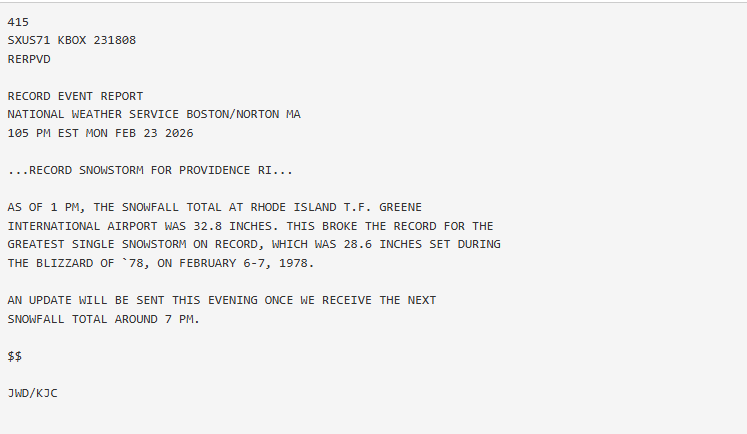
-
"Don’t do it" 2026 Blizzard obs, updates and pictures.
DJln491 replied to Ginx snewx's topic in New England
Love it. Did he go berserk? -
"Don’t do it" 2026 Blizzard obs, updates and pictures.
DJln491 replied to Ginx snewx's topic in New England
That counterclockwise rotation I think even WOR should get some of the goods in the coming hours -
"Don’t do it" 2026 Blizzard obs, updates and pictures.
DJln491 replied to Ginx snewx's topic in New England
Just dumping right now in W Hartford let’s hope it continues -
some people are going to get a foot of snow and be pissed
-
Friday February 6 FROPA / WINDEX small event
DJln491 replied to HoarfrostHubb's topic in New England
Just enough to cover up the visible dog pee in the snowbanks. we take -
Possible coastal storm centered on Feb 1 2026.
DJln491 replied to Typhoon Tip's topic in New England
How bout them 00z runs tonight?! Interesting for sure -
Possible coastal storm centered on Feb 1 2026.
DJln491 replied to Typhoon Tip's topic in New England
Start high. But dont worry, we can always go higher -
Possible coastal storm centered on Feb 1 2026.
DJln491 replied to Typhoon Tip's topic in New England
Stronger but easterer -
Dumping in W Hartford right now
-
Same here in W. Hartford. some larger flakes getting mixed in. Around 12" so far. Loving it personally, no complaints.
-
I’m in W Hartford and just measured the same. It was pretty darn close to 8”
-
Those bands that came thru CT look like they’ve amped up even more heading towards Boston


