

Owensnow
-
Posts
134 -
Joined
-
Last visited
Content Type
Profiles
Blogs
Forums
American Weather
Media Demo
Store
Gallery
Posts posted by Owensnow
-
-
12 minutes ago, Lightning said:
Yeah. Models showed a changeover by 4 am. Actual was was 6 am.
 Really like my call for 6"-8".
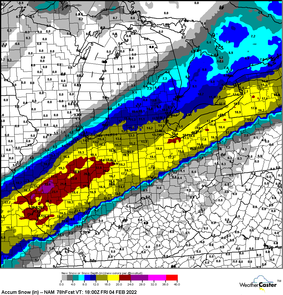
Mean Plumes are still around 10 for DTW at 10:1
-
40 minutes ago, Frog Town said:
Pulling teeth here in Toledo. This is the part I hate the most....Waiting for the snow to transition.
Plumes have decreased a bunch from 3Z
Really hoping once again for a NW correction
-
1 minute ago, Stevo6899 said:
Precip is def further north into mich on the 0z nam.
woot
-
35 minutes ago, snowman33 said:

Absolute hose! Is there a thunder indicator in that map?
-

Plumes at TTF up to 12.35 inches mean now from 10.1 earlier. Range is 11-18 (lots of members in the 13-18 camp
-
What are chances for thunder? I am showing some on the accuweather KIWX radar. Turn on the storm timer and there are 3 cells being tracked heading into SW lower MI lol
-
-
18Z Canadian starting to come back NW
Come on baby!
-
 1
1
-
-
15 minutes ago, michsnowfreak said:
You can still easily get 11-15 on 1" qpf. It's basically now cast time.
I had 1.08" on 16.5" Feb 1/2, 2015
They are advertising 12 to 1 ratio is at the office
-
1
-
-
16 minutes ago, michsnowfreak said:
DTX upgraded to warning for 11-15".
Must be hinging on the RGEM
because no other model solutions have any more than about 1 inch of QPF
-
1
-
-
Just now, Stevo6899 said:
Man what couldve been if the second part/main wave could amplify a bit and come nw, it could've been a historic storm for dtw. Maybe it still can, who knows.
Agreed
Here is hoping, perhaps todays high temps will reposition the eventual boundary?
Cheers
-
 1
1
-
-
12Z RGEM is better for DTW and Myself here at XHA.
10-16 inches verbatim @ 12:1 or more
-
1
-
-
7 minutes ago, ILSNOW said:
15z RAP still rapping (best model) 12z RGEM holds serve

God I hope the RAP is on to something. Everything else is SE now
-
1 minute ago, RobertSul said:
The GFS performed terribly with the Boston blizzard. Too far SE and too dry.
I hope you are right. Really need that 2nd wave to stay in the double digit totals.
-
1 minute ago, Ottawa Blizzard said:
The latest run of the Canadian model seems to bring heavier precipitation further northwest for the second wave on Thursday...
Quickly shunts to the east though, need to be more amplified. At least for me.
-
2 pronged storm just became 1 for DTW and XHA here at my place, north shore of lake Erie accros from Sandusky. No snow at all hardly from wave 2. All south.
Wonder if the trend continues for the first wave inclusive?
What is happening/ PV ?
-
Just now, Weather Mike said:
not good for chicago so we must throw that run out
I know, the trend is nerve racking!
Arctic air looks to be winning the push?
-
Just now, Sciascia said:
Guys, calm down. The 15z RAP is running!
…Hey, get back here, straws!

Gonna need them up here. We were forecast 12-16 per DTW but now 2nd wave is trending SE consistently. Now looking at 6-10 maybe
-
-
3 minutes ago, nwohweather said:
As of now this looks like an entirely incorrect statement

Check your plumes
-
LOL Nam 12z has CLE in jackpot south of me.
These models are making me nutz
-
1 minute ago, michsnowfreak said:
Wednesday has turned into the main show here anyway. Or so it appears.
There is always the RGEM
It looked great at 6Z
-
1
-
-
15 minutes ago, Stevo6899 said:
Typical news hype, local news saying this could be one of detroits largest on record. Im just not seeing it. I still feel like if it takes 36 hrs, it shouldn't count as one event. I hope those in N in, IL and nw ohio can cash in on a 2 footer.
Me too...lots of time yet but looks like Se trend. SREF plumes beg to differ though. They are the opposite of the SE trend
-
14 minutes ago, Chicago WX said:
Changeover went from early Wed AM to PM now here to DTW. Models are shifting / adjusting to various factors obviously. Not confident at this juncture in mega totals here.


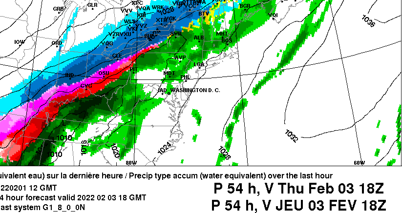
Feb 1-3rd GHD III Part 3
in Lakes/Ohio Valley
Posted
If we cant get a changeover BEFORE that huge batch of yellow returns to the south, I think wave 1 is a bust.