

mannynyc
-
Posts
411 -
Joined
-
Last visited
Content Type
Profiles
Blogs
Forums
American Weather
Media Demo
Store
Gallery
Everything posted by mannynyc
-
It's worse than that. For some folks it's not a pattern change unless we get a massive coastal storm.
-
Well at least we have 300+ hour fantasies
-
People forget that last winter was so bad we weren't even getting 300 hour fantasy blizzards from the GFS
-
I mean the coastal low is there, but so is the rain...
-
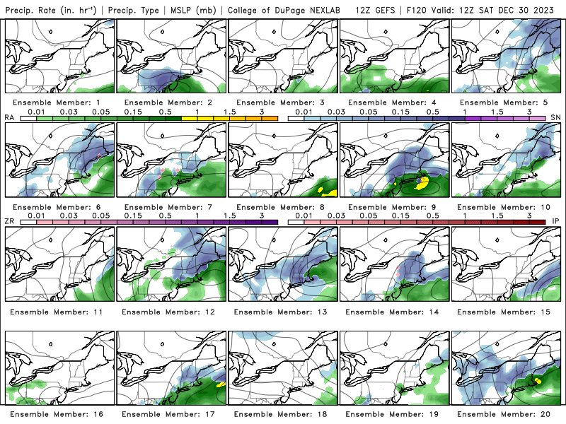
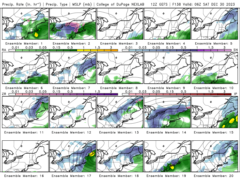
Not a great look on the GEFS ensembles but it's better than tracking nothing
-
Doesn't need to be a big piece storm to end NYC's snow drought. A well placed piece of energy can give us 1-2 inches and remove the lid.
-
Obviously not great but a 1-3 degree F anomaly doesn't mean it can't or won't snow, though it certainly will be harder. This shouldn't be used as a declaration of winter being over.
-
It's May 12th and I'm already ready for Winter. Good grief
-
And that's why I spend my summers in Maine
-
Yup, there was still some light snow at 7:30PM/8PM tonight
-
Obviously disappointing we didn't get a significant snowfall in NYC, not that one was expected, but walking outside with the snow falling this evening really reminded me why I loved winter. There was something about walking through the snowfall and seeing it gleam in the light that made me really happy.
-
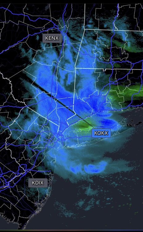
Radar is filling in nicely. Best chance for accumulating snow, especially outside NYC, the next few hours.
-
The GFS has been in and out for a perfect coastal storm for this time period. Would like more ensemble support but this is still in a reasonable window.
-
RGEM has a warm bias, that's why it was showing rain instead of the snow the city is getting. Something to note when using it, especially with borderline events.
-
Wouldn't put too much much faith in the NAM at this point. It's not picking up on the secondary low over CT.
-
Models suggest the snow is going to dry up by then
-
Snow mixing with rain in the city. Nothing unexpected
-
Still think north shore will accumulate. Lots of models like bands setting up over LI. On the other hand, every time the GFS has shown 1-2inch in the city nothing has fallen so I’m betting against anything in the city.
-
This would be a great look in January and February but find it hard to believe it is going to stick in the middle of the day. Need really good rates.
-
I think the north shore is one place that has an oppertunity to bust high. Looks like they might get a nice band of snow as the low pulls out
-
Higher than the NAM. Hard to believe
-
The last hurrah? Putting all the eggs in the Tuesday 3/14 basket
mannynyc replied to Ginx snewx's topic in New England
3k NAM still has the low hundreds of miles off shore -
Do you trust the long range HRRR or the NAM? Or maybe neither?
-
NAM is west because of course it is
-
Timing is another thing that has burned us with this storm. Going to be hard to accumulate in the mid-30s in the middle of the day, especially in the City and south.


