

SnowenOutThere
-
Posts
3,943 -
Joined
-
Last visited
Content Type
Profiles
Blogs
Forums
American Weather
Media Demo
Store
Gallery
Everything posted by SnowenOutThere
-

February 11-12; 12-13: Are they real??
SnowenOutThere replied to stormtracker's topic in Mid Atlantic
GFS is running, good luck to all -
February 11-12; 12-13: Are they real??
SnowenOutThere replied to stormtracker's topic in Mid Atlantic
NAM seems like it would keep precip around for an extended time even after wave two, which may lend itself to a decent snow to ice event before the thermals are completely destroyed by the Thursday storm -
February 11-12; 12-13: Are they real??
SnowenOutThere replied to stormtracker's topic in Mid Atlantic
Wonder if part of that reduction is from the "storm" today no longer being counted? -
February 11-12; 12-13: Are they real??
SnowenOutThere replied to stormtracker's topic in Mid Atlantic
Maybe I'm misremembering 6z but that seems somewhat significantly souther -
Yo @psuhoffman I know it is the long range GFS, but is this a legitimate possibility of the upcoming pattern. Just asking because we have seen something like this the past couple years...
-
Had light snow with sleet for around an hour, no accumulation but very pretty
-
February 11-12; 12-13: Are they real??
SnowenOutThere replied to stormtracker's topic in Mid Atlantic
Think it may be time to start a new thread on this one and try to use the second thread revival trick of last year… -
I cannot wait till the line of threads each named PSU storm 1, 2, and so on come Feb 20th
-
February 11-12; 12-13: Are they real??
SnowenOutThere replied to stormtracker's topic in Mid Atlantic
Well, for those so suddenly worried about suppression I'm pretty sure the CMC will be too far the other way -
February 11-12; 12-13: Are they real??
SnowenOutThere replied to stormtracker's topic in Mid Atlantic
I mean, I would say this is bad at all south of the Potomac -
February 11-12; 12-13: Are they real??
SnowenOutThere replied to stormtracker's topic in Mid Atlantic
It is getting squashed more by a piece of vorticity in southern Canada that was further north on the 18z run, along with being weaker in general -
February 11-12; 12-13: Are they real??
SnowenOutThere replied to stormtracker's topic in Mid Atlantic
It also appears to be colder, though I do wonder if what the GFS is showing right now with weaker pressure out west will end up better setting us up for the storm after this thread -
February 11-12; 12-13: Are they real??
SnowenOutThere replied to stormtracker's topic in Mid Atlantic
Generally seems a little weaker out west but may change -
February 11-12; 12-13: Are they real??
SnowenOutThere replied to stormtracker's topic in Mid Atlantic
Well I suppose the alternative would be making a week long running thread with different OBS threads getting spun off it, though that sounds messy but would allow us to separate out this week from the PSU pattern. -
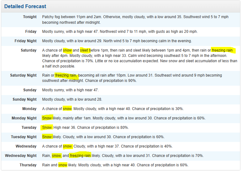
Not sure when the last time a majority of the NWS has had frozen mentioned in it
-
Surprisingly still below freezing near Reston with .5 of rain overnight trees are very saggy
-
ICON is very nice, keeps everything cold while not having us out of the best precip
-
My bad, I meant to say all aboard the hype train! I guess Ji must've gotten into my account somehow. In all serious though was just trying to mitigate the "its so over" cycle when the models only show a foot before the ultimate comeback.
-
Hate to put a little bit of a downer on this hype train but is important here to note there is only (lmao) around a 70% chance of an inch in a 24 hour period around the time period. I'm sure it would be around 80% if it were around 48 hours long but just want to put in that though things look very good not all our eggs should be in this basket (future reference if this threat falters and certain people try to cancel the pattern).
-
How about it may be about to happen. Thats where I'm at currently.
-
Agree with that but a later start time (as long as there’s a “base layer” by sunrise) also increases impacts and the chance I get school off so…
-
Going to start sleeping 16+ hours a day to skip time
-
Or a whole new thread, I’m all for tracking a nice snow/wintery mix for the weekend to help in the waiting for the 12th to lock in
-
Euro is a tick colder but also drier.
-
I first joined this forum back in 2021 and this is by far the best signal I have ever seen. Excited to see what happens.


