

SnowenOutThere
-
Posts
3,943 -
Joined
-
Last visited
Content Type
Profiles
Blogs
Forums
American Weather
Media Demo
Store
Gallery
Everything posted by SnowenOutThere
-
Would also want to enjoy the day sledding with my friends and stuff. If I do go do you have any recs on where to take pics?
-
Capital Weather Gang article mentions the possibility of frontal enhancement in its latest article as "There are also some indications that the jet stream pattern and localized fronts may help intensify snow over our region". Has 35% of 3-6 for DC, 35% 6+ for DC, 20% 1-4 because mixing issues, and 10% chance of 1-4 for DC due to missing to the south. https://www.washingtonpost.com/weather/2025/01/02/dc-region-snow-storm-forecast-ice-winter-weather/?utm_source=twitter&utm_medium=social&utm_campaign=wp_weather
-
The metro should be a lifesaver for anyone who needs to be out and about Monday. Might be fun to head into DC on the silver line and take some pictures
-
I would be upset at the return of the infamous DC claw but hard to complain about only getting 8-10 instead of 10+
-
Do not need to worry about QDF on that run, would be a fun winters morning even if it gets a bit icy
-
CMC looks decent according to this site https://collaboration.cmc.ec.gc.ca/cmc/cmdn/pcpn_type/pcpn_type_gem_reg.html, though does have IAD and DCA mix for a time before flipping to heavy snow.
-
You were just a little premature in posting that
-
Has a little bit of backend snow at hour 108, and honestly (though a met may want to chime in) seems somewhat close atmospherically to having a more prolonged period of coastal enhancement.
-
Pivotal has a weird brief period of mixing hit DC around hour 93 before heavier precip switches it back to snow but with this sounding it may just be snow.
-
Seems like it should be at the very least a decent run for us, definitely not a shift to the Euro though.
-
Yeah it was mainly just an exercise in having too much time on my hands, besides we all know the only model to really take seriously is the CFS
-
While we're between run I looked at the NAM and FWIW at the end of its run looks to have more confluence further southwest than the 6z GFS while also having a slightly stronger southwest. I assume this would turn out well for us but I'm also by far not the best person here to analyze it.
-
I volunteer to start the second thread to bring the storm back if this happens
-

January Medium/Long Range: A snowy January ahead?
SnowenOutThere replied to mappy's topic in Mid Atlantic
https://x.com/burgwx/status/1874606351701475799?t=Si4ZRrKNNJ68cDEWkY2Row&s=19 Post over at twitter seemed informative in the two ways this might go a little too far north for our liking @OSUmetstud mentioned he believed that the second way outlined in the post seems more likely than the first FWIW and in the second outcome it would most likely just help the coastal get going so we wouldn't necessarily lose out on snow from it. -
January Medium/Long Range: A snowy January ahead?
SnowenOutThere replied to mappy's topic in Mid Atlantic
Oh wow, I was expecting maybe a tenth of an inch or something. Even if just half (or frankly a quarter) of that was legit freezing rain that could accrete it definitely could help in giving me an extra long winter break. -
January Medium/Long Range: A snowy January ahead?
SnowenOutThere replied to mappy's topic in Mid Atlantic
Would be nice if @NorthArlington101 (or any other person who paid for model runs) could post the freezing rain/sleet accumulation maps -
January: Medium/ Long Range: May the Force be with Us....
SnowenOutThere replied to Weather Will's topic in Mid Atlantic
Way out to the 15th but the GFS is actually pretty close to a hit, so even if both Monday and next weekend fails we still have another shot. -
January: Medium/ Long Range: May the Force be with Us....
SnowenOutThere replied to Weather Will's topic in Mid Atlantic
Hey, did you know Prince died? -
January: Medium/ Long Range: May the Force be with Us....
SnowenOutThere replied to Weather Will's topic in Mid Atlantic
Its so close to a phase that could've brought it up the coast too but the NS kicks it instead. -
January: Medium/ Long Range: May the Force be with Us....
SnowenOutThere replied to Weather Will's topic in Mid Atlantic
If it was just a little bit further north it actually would be a pretty good run, has a better snow max but is just a bit too far south. -
January: Medium/ Long Range: May the Force be with Us....
SnowenOutThere replied to Weather Will's topic in Mid Atlantic
I support this being a thread but making one as the GFS is running wasn't the best timing. -
January: Medium/ Long Range: May the Force be with Us....
SnowenOutThere replied to Weather Will's topic in Mid Atlantic
Has it really? Looks like it may have been partying a little hard over the past couple days.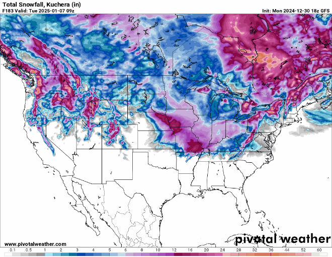
-
January: Medium/ Long Range: May the Force be with Us....
SnowenOutThere replied to Weather Will's topic in Mid Atlantic
Its also significantly faster than 6z with the storm in general -
January: Medium/ Long Range: May the Force be with Us....
SnowenOutThere replied to Weather Will's topic in Mid Atlantic
Precip shield seems to be weakening on approach... -
January: Medium/ Long Range: May the Force be with Us....
SnowenOutThere replied to Weather Will's topic in Mid Atlantic
Southwest and low looks a little more powerful and the confluence is slightly further north (Connecticut vs New York City on 6z) at hour 105


