WXNewton
-
Posts
573 -
Joined
-
Last visited
Content Type
Profiles
Blogs
Forums
American Weather
Media Demo
Store
Gallery
Everything posted by WXNewton
-
February 19-20 Major Winter Storm Threat
WXNewton replied to NorthHillsWx's topic in Southeastern States
12z GEFS and 6z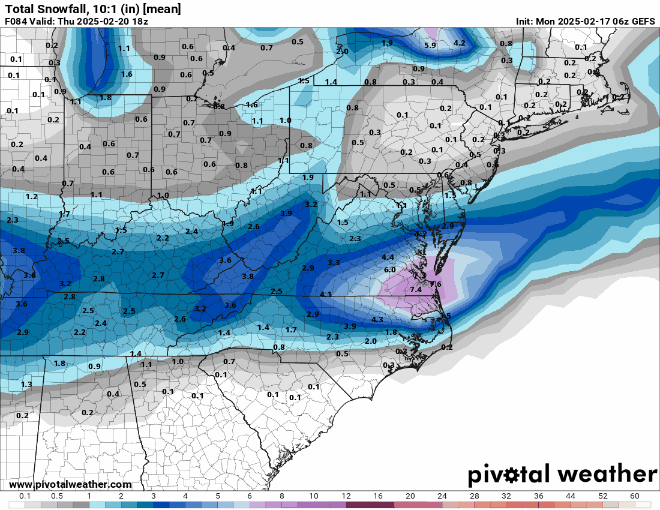
-
February 19-20 Major Winter Storm Threat
WXNewton replied to NorthHillsWx's topic in Southeastern States
ICON with a nice uptick back here in the NW Piedmont!.gif.e63a1cce5e0cead1f1195c9e33b735d4.gif)
-
February 19-20 Major Winter Storm Threat
WXNewton replied to NorthHillsWx's topic in Southeastern States
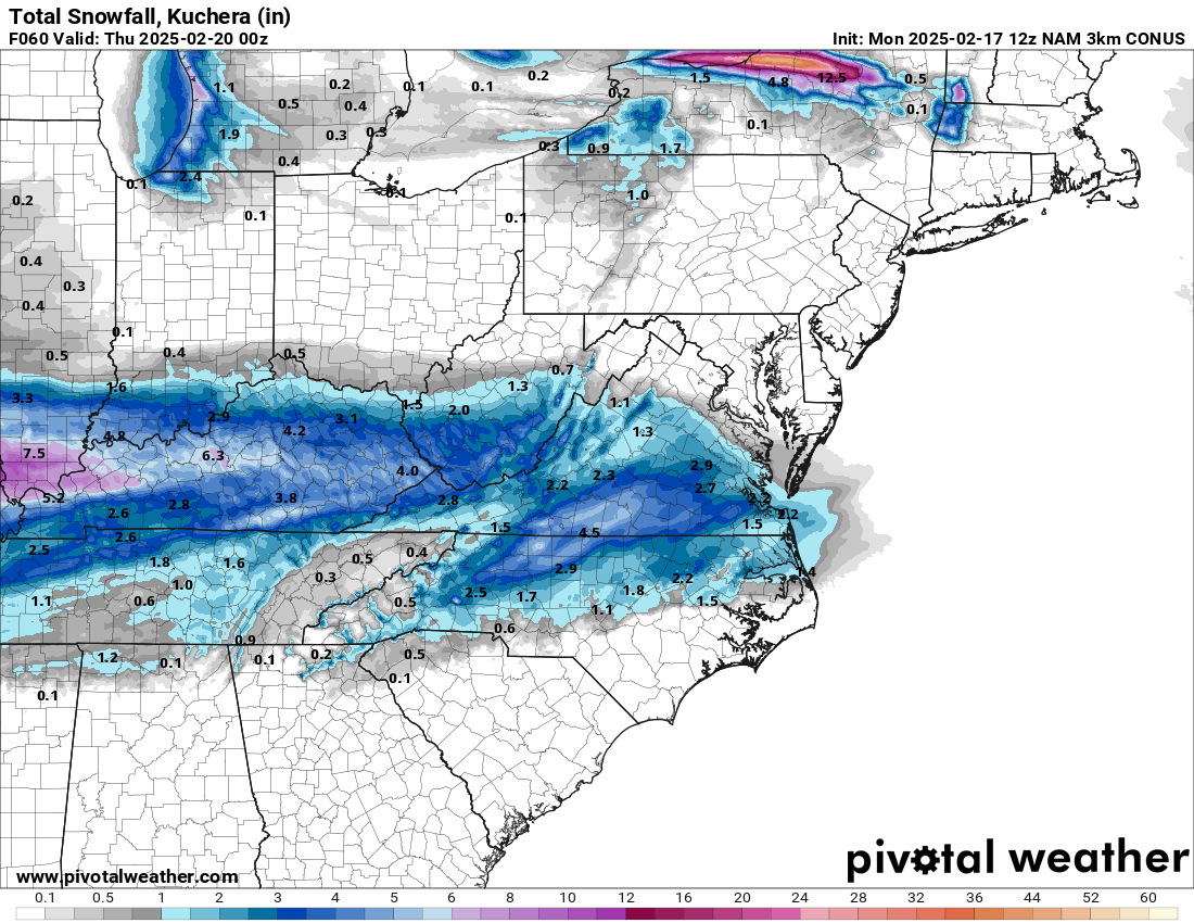
12z 3km Nam...Hope it's on to something because this looks great.

-
February 19-20 Major Winter Storm Threat
WXNewton replied to NorthHillsWx's topic in Southeastern States
Since the 12z runs about to start, are going positive trends start now or does the bleeding keep happening? -
February 19-20 Major Winter Storm Threat
WXNewton replied to NorthHillsWx's topic in Southeastern States
Just think it changed this much in one day. -
February 19-20 Major Winter Storm Threat
WXNewton replied to NorthHillsWx's topic in Southeastern States
I am just going to go with it didn't process correctly because it seemed like there was moisture then boom no moisture, it certainly didn't seem realistic. -
February 19-20 Major Winter Storm Threat
WXNewton replied to NorthHillsWx's topic in Southeastern States
Yeah prepare the lifeboats it looks like. I was hoping to at least get NAM'ed, but that will have to wait until morning now. -
February 19-20 Major Winter Storm Threat
WXNewton replied to NorthHillsWx's topic in Southeastern States
Yeah it's not going to get any better once the Euro hits tonight... Sitting back here in the west and watching this today has been tough, I guess once you hit rock bottom any improvements from here will be a win. -
February 19-20 Major Winter Storm Threat
WXNewton replied to NorthHillsWx's topic in Southeastern States
CMC had additional snow in the WNC like the RGEM and ICON after the initial storm moved off the coast. That would be interesting with temps in the upper teens and low 20s. -
February 19-20 Major Winter Storm Threat
WXNewton replied to NorthHillsWx's topic in Southeastern States
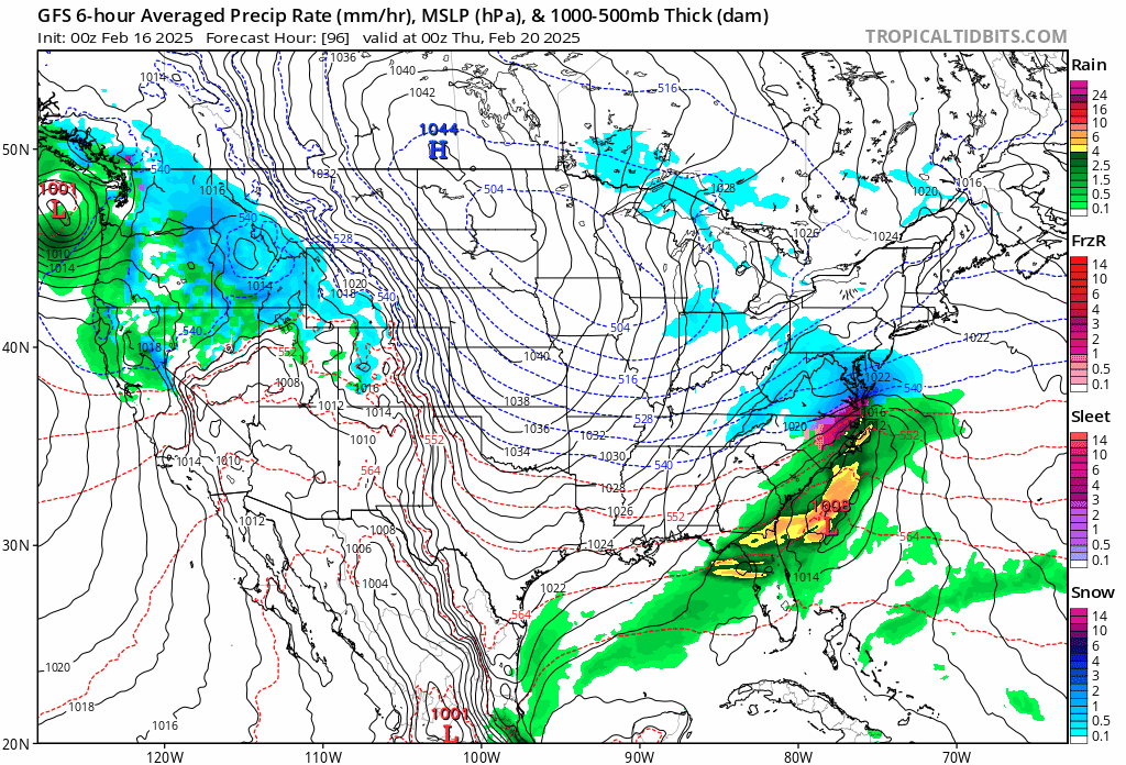
GFS is slowly trending moisture an the low pressure back to the sw each run, it will be interesting to see how far this will go over the next day or two.
-
February 19-20 Major Winter Storm Threat
WXNewton replied to NorthHillsWx's topic in Southeastern States
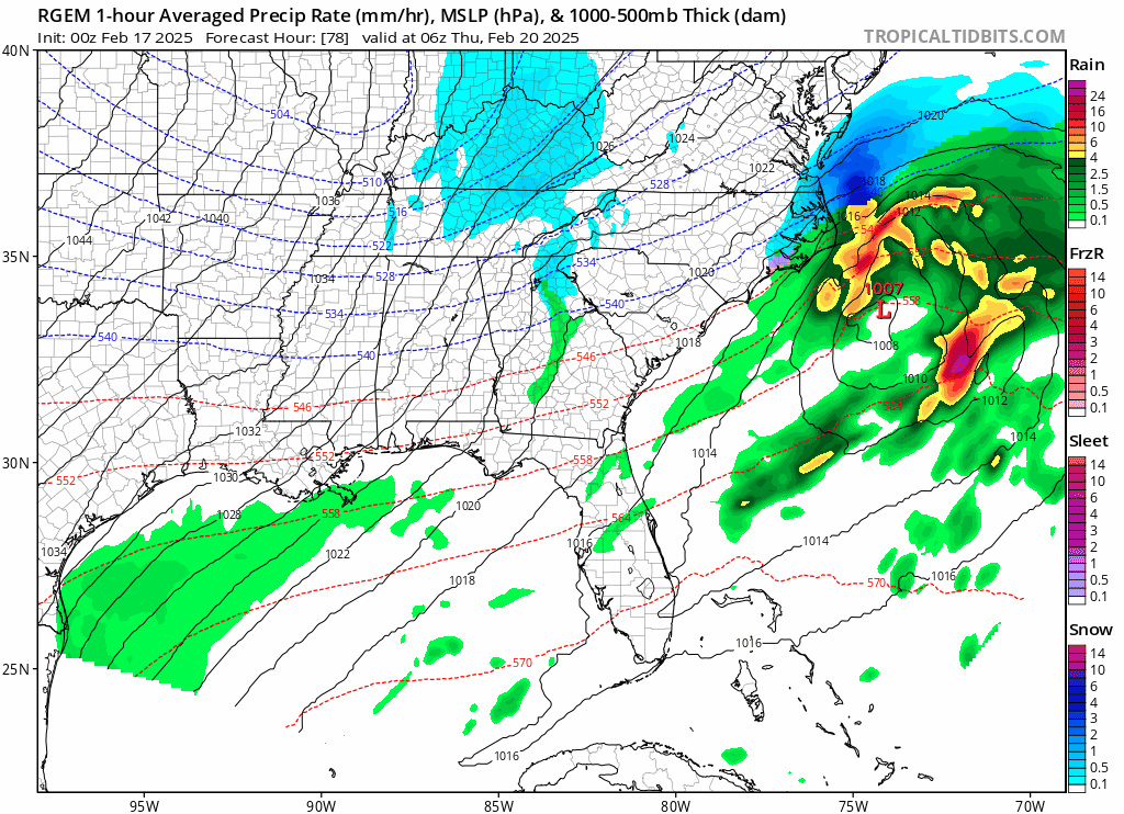
The RGEM like the ICON moves a second wave of snow through after the first storm. This feature might be something to watch over the next few days to see if there is additional potential there.
-
February 19-20 Major Winter Storm Threat
WXNewton replied to NorthHillsWx's topic in Southeastern States
Even though there is a precip min back here in the west on the ICON, the trend here over the past few runs suggest that the moisture is slowly progressing back to the sw a little more each run and the low pressure over the gulf is further sw each run and a little slower. I would think over time this progression would lead to more phasing of the low over the gulf and we would see precip totals ramp back up more in the west. The GFS is slowly making that same progression, it's not much but over the next three days it might make a big difference. Just my .02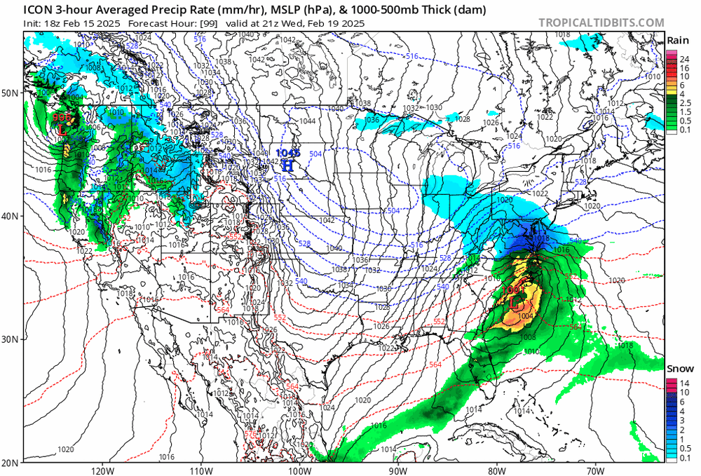
-
February 19-20 Major Winter Storm Threat
WXNewton replied to NorthHillsWx's topic in Southeastern States
There was a storm here in Jan of 2018 which had a similar projected trajectory as this one. The models struggled with the lee side up until right before the storm and I believe the HRRR was the first to show it, but we developed a lee side low which enhanced the moisture and actually had a decent storm here. I'll try to find the map on it. This was the storm... https://products.climate.ncsu.edu/weather/winter/event/?e=627 https://climate.ncsu.edu/blog/2018/01/rapid-reaction-seasons-third-snow-did-things-its-own-way/ -
February 19-20 Major Winter Storm Threat
WXNewton replied to NorthHillsWx's topic in Southeastern States
-
February 19-20 Major Winter Storm Threat
WXNewton replied to NorthHillsWx's topic in Southeastern States
I can say a lot of times for HKY the amount of precip in a rain storm has been pretty spot on. I've compared it to my rain gauge many times and it's been with-in a tenth of an inch. So maybe as far as storm QPF it's not too terrible from my personal experience. -
February 19-20 Major Winter Storm Threat
WXNewton replied to NorthHillsWx's topic in Southeastern States
I know the SREFs get tossed out a lot, but right now between cycles there isn't much else to discuss so here's another snow mean trend to look at of tonight's latest and the 15z run. -
February 19-20 Major Winter Storm Threat
WXNewton replied to NorthHillsWx's topic in Southeastern States
Yeah could be...if the models don't start expanding back our way by lunchtime tomorrow, us back out west might be toasted. -
February 19-20 Major Winter Storm Threat
WXNewton replied to NorthHillsWx's topic in Southeastern States
Yeah I looked at precip amounts, def was further south but also less precip than lunchtime. -
February 19-20 Major Winter Storm Threat
WXNewton replied to NorthHillsWx's topic in Southeastern States
GEFS out to 60 looks juicier than OP, we shall see how well they agree. -
February 19-20 Major Winter Storm Threat
WXNewton replied to NorthHillsWx's topic in Southeastern States
Filled in the snow hole back here in the west, I'll take that as a plus for MBY for the time being. -
February 19-20 Major Winter Storm Threat
WXNewton replied to NorthHillsWx's topic in Southeastern States
CMC Ens. Actually trended a lot better for many. -
I agree, I think we will see more precip in our area than what most of the models are currently depicting.
-
February 19-20 Major Winter Storm Threat
WXNewton replied to NorthHillsWx's topic in Southeastern States
So are you thinking QPF will increase as we get closer to the storm vs the model QPF output we are seeing now? Once the models figure out the exact track of the low pressure will we see this translate to more of a widespread precip on the surface maps? -
February 19-20 Major Winter Storm Threat
WXNewton replied to NorthHillsWx's topic in Southeastern States
Canadian actually is improving some each run, filling in more moisture each run. Last 3 runs... -
February 19-20 Major Winter Storm Threat
WXNewton replied to NorthHillsWx's topic in Southeastern States
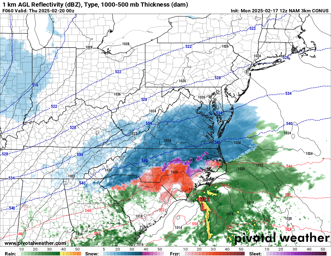
ICON seems to be trending the energy back south and west each run.