WXNewton
-
Posts
573 -
Joined
-
Last visited
Content Type
Profiles
Blogs
Forums
American Weather
Media Demo
Store
Gallery
Everything posted by WXNewton
-
Me too, actually just counted 9.
-
https://www.resortcams.com/webcams/mountain-credit-union-waynesville/
-
Starting to see a few flakes south of Newton.
-
Waynesville looked like pretty steady snow on their cam too.
-
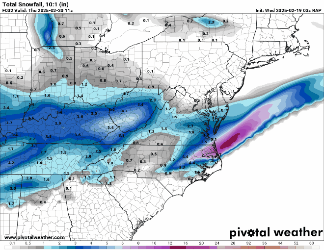
Last 3 Rap models are increasing moisture and totals slowly back here in the west. It's not much but when you are at rock bottom already anything positive gives us hope. Also has about 4 hrs of snow on Thursday morning that is dropping another 1/2" or more.
-
When the euro had HKY at like 10-11" on Friday or Saturday night, I said oh no here we go, no one wants to be in the bullseye 4 days out.
-
You are going to need a virtual snowblower for all of that.
-
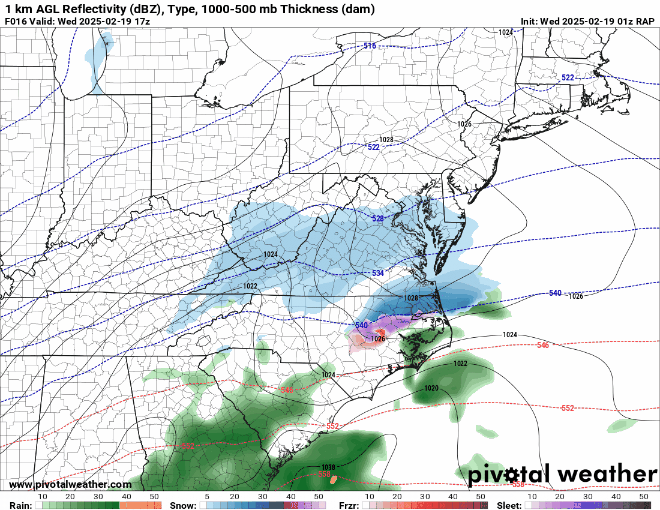
Brad P. Says that the lull in precip back here in the West is due to the low pressure basically jumping to the east coast and transferring the best lift and energy to the east for the coastal to take over.
-
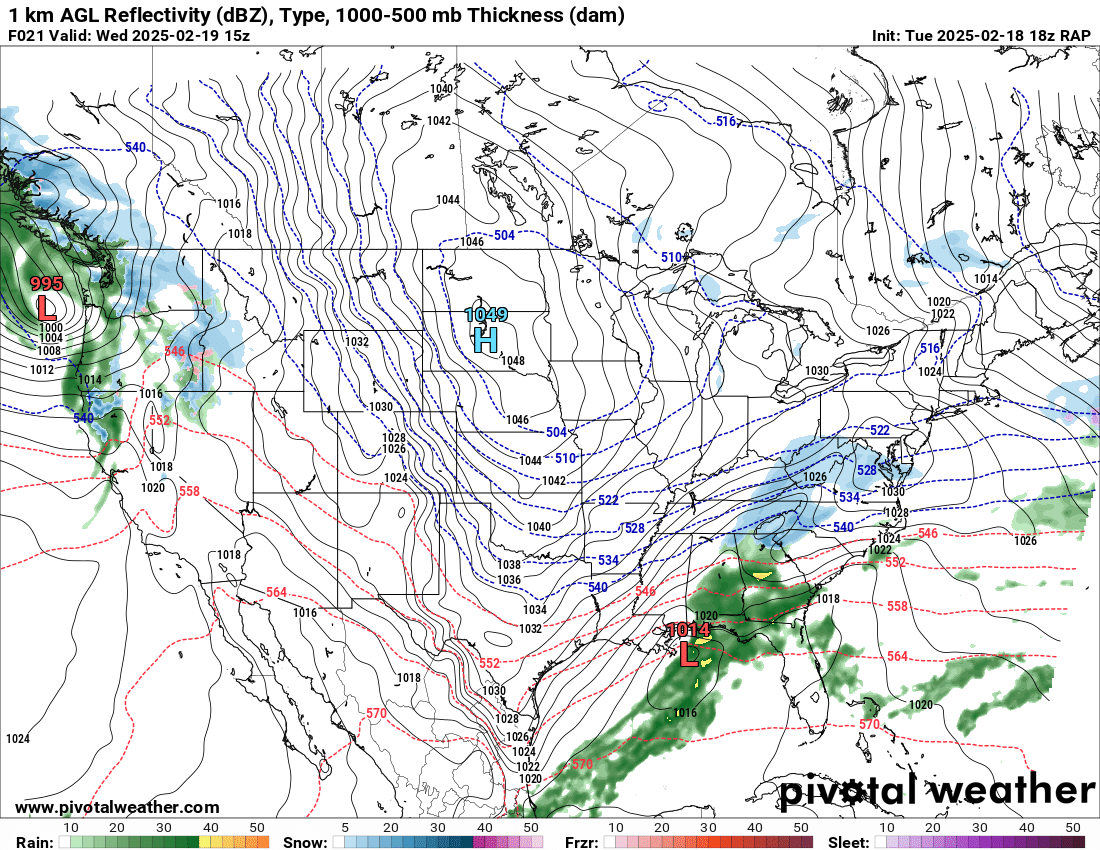
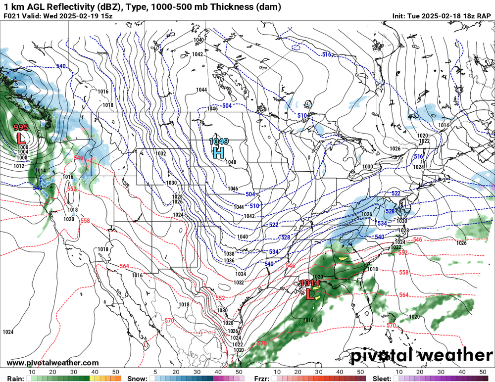
RAP at the end of the run has snow breaking out and lifting under SW MTNS.
-
It's hard for me to believe that we won't have some moisture develop once the energy sneaks up and under the SW MTNS. I can't recall a storm tracking across the N.Gulf with a good look shield of precip that just dries up as it moves east. The models obviously see something, but still it's hard for me to believe. Op
-
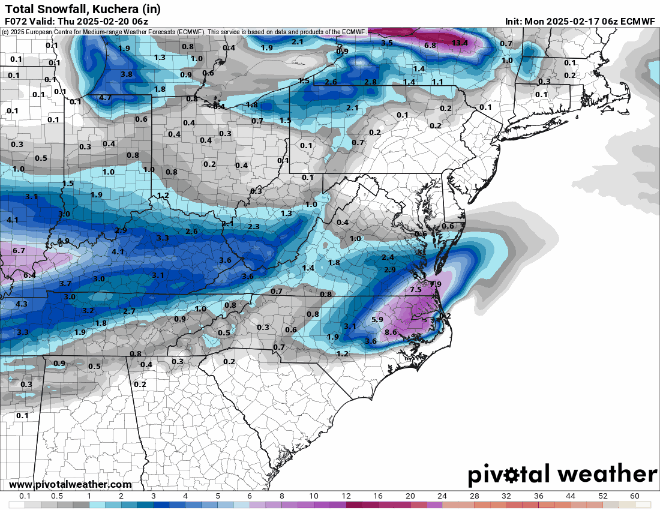
February 19-20 Major Winter Storm Threat
WXNewton replied to NorthHillsWx's topic in Southeastern States
SREF QPF over the last 3 runs.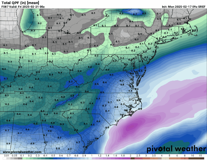
-
February 19-20 Major Winter Storm Threat
WXNewton replied to NorthHillsWx's topic in Southeastern States
I know got kind of happy and couldn't even wait until the end of the run. -
February 19-20 Major Winter Storm Threat
WXNewton replied to NorthHillsWx's topic in Southeastern States
21z SREF uptick from 15z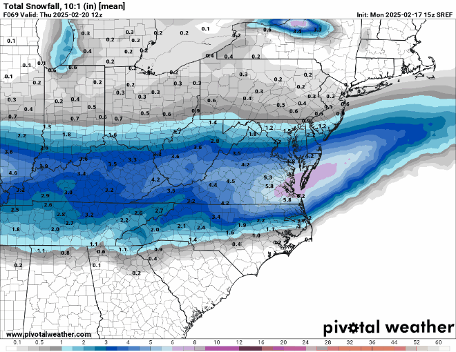
-
February 19-20 Major Winter Storm Threat
WXNewton replied to NorthHillsWx's topic in Southeastern States
EPS trended a little better than 12z also wetter than OP.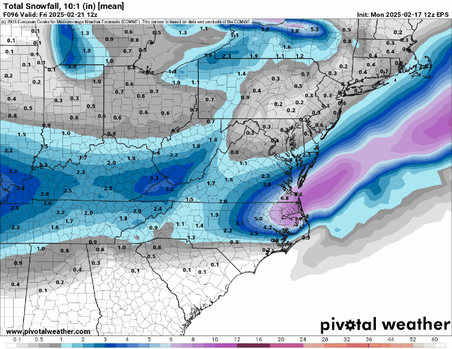
-
February 19-20 Major Winter Storm Threat
WXNewton replied to NorthHillsWx's topic in Southeastern States
Yeah the places that are seeing the biggest increase right now seems to be in TN and KY, N. MIss, spine of the APPs and some of WNC. The northern part of the QPF increased some and stayed stronger longer. -
February 19-20 Major Winter Storm Threat
WXNewton replied to NorthHillsWx's topic in Southeastern States
Last 4 runs of GEFS -
February 19-20 Major Winter Storm Threat
WXNewton replied to NorthHillsWx's topic in Southeastern States
18z GEFS really had a nice uptick in QPF in WNC this run, here is the last 3 runs to compare.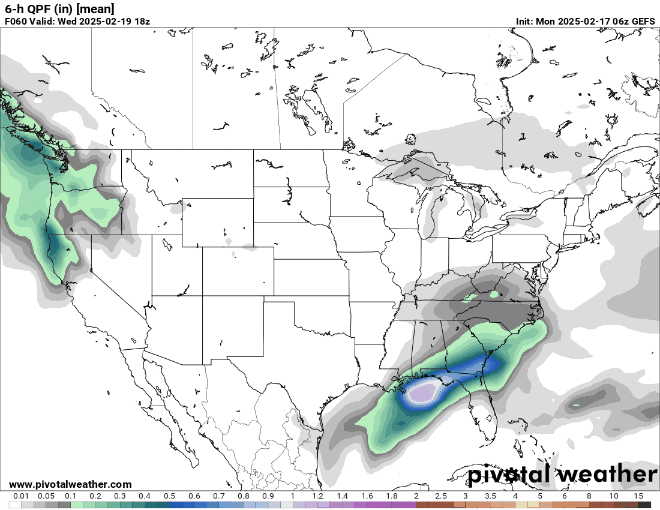
-
February 19-20 Major Winter Storm Threat
WXNewton replied to NorthHillsWx's topic in Southeastern States
18z and 12z GFS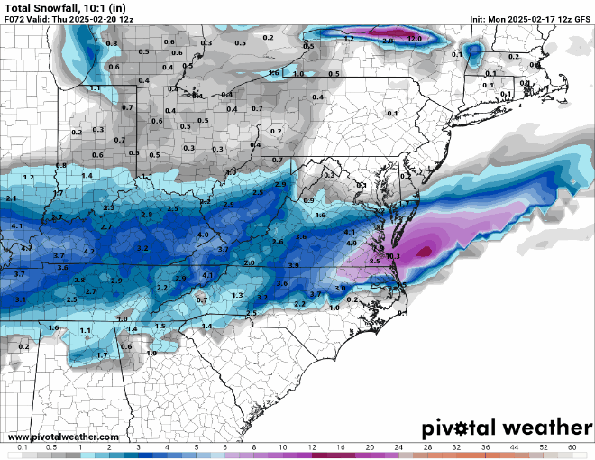
-
Here's a great site I use to watch past radars. You can put in pretty much any date back to 1995. https://www.ncei.noaa.gov/maps/radar/
-
February 19-20 Major Winter Storm Threat
WXNewton replied to NorthHillsWx's topic in Southeastern States
12z CMC ENS and 00z ENS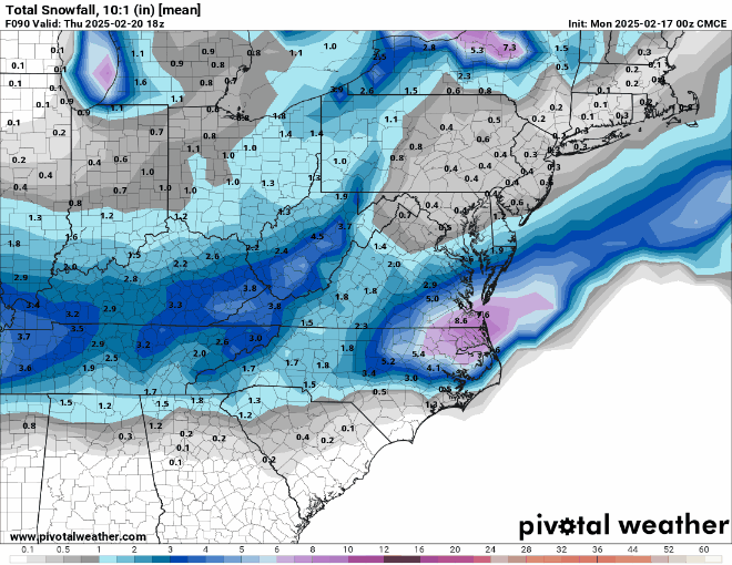
-
February 19-20 Major Winter Storm Threat
WXNewton replied to NorthHillsWx's topic in Southeastern States
Latest Sref compared to this morning's run.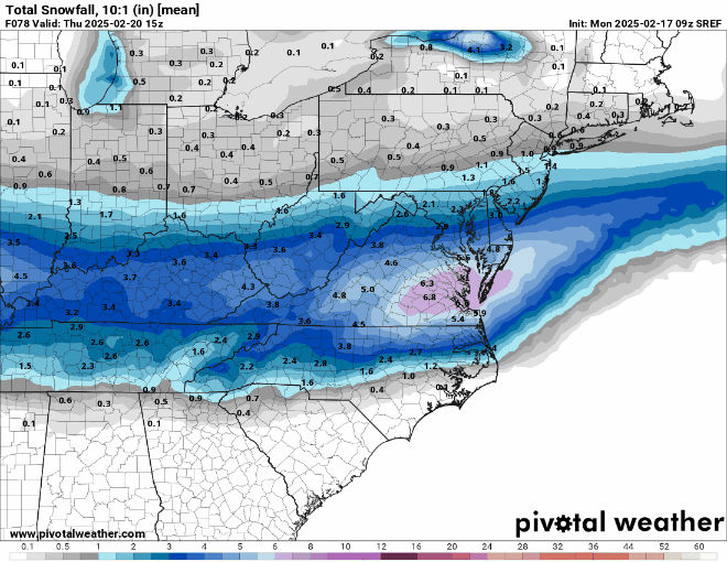
-
February 19-20 Major Winter Storm Threat
WXNewton replied to NorthHillsWx's topic in Southeastern States
The other thing to mention on the EPS is the trend to develop some backside banding with the upper low as it pivots through. Like several other models this piece of energy is starting to develop more and more on the backside of the storm.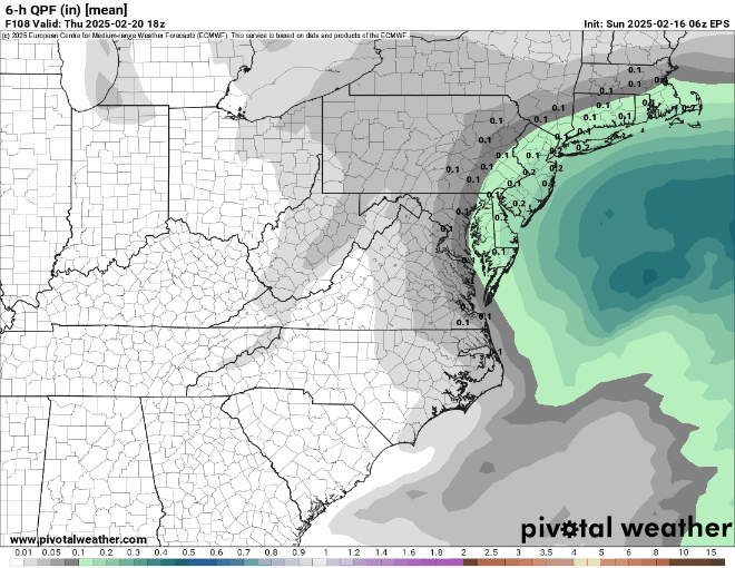
-
February 19-20 Major Winter Storm Threat
WXNewton replied to NorthHillsWx's topic in Southeastern States
The biggest change that I noticed on the EPS is the moisture in TN and KY really tried to ramp up some. If this piece of the storm trends back stronger and stronger each run, maybe it leads to more of a front end thump for WNC?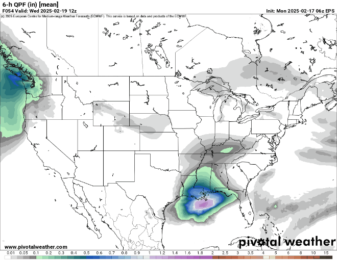
-
February 19-20 Major Winter Storm Threat
WXNewton replied to NorthHillsWx's topic in Southeastern States
12z and 6z EPS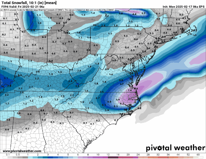
-
February 19-20 Major Winter Storm Threat
WXNewton replied to NorthHillsWx's topic in Southeastern States
Euro was better for some MTN counties as well as parts of TN and KY. The northern part of the storm produced a little more precip this run and held on longer before dying out.