Hypothetical 240 hour snow
-
Posts
71 -
Joined
-
Last visited
Content Type
Profiles
Blogs
Forums
American Weather
Media Demo
Store
Gallery
Everything posted by Hypothetical 240 hour snow
-
Jan. 31-Feb. 2 Miller B storm
Hypothetical 240 hour snow replied to LVblizzard's topic in Philadelphia Region
All the "Prob-Snow" maps the NWS makes uses those set numerical ranges, so they have no control over it... that map can be missleading though since they actually have 12 inches forecast for both Philly and ABE, yet the interpolation on their snowfall maps shows Allentown at 8-12. Overall that map seems reasonable... I am surprised they put Philly in the 12-18 bin so early, but it is right at 12 inches forecast, so could just as easily say 8-12. -
Jan 31st - 33rd Storm Obs and Disco like it's 1979
Hypothetical 240 hour snow replied to Bob Chill's topic in Mid Atlantic
Another nice hold by the RGEM... as someone pointed out earlier if will be interesting to watch if the coastal gets dragged/reforms under the offshore convection (not a given for a baroclinic system) like the NAM shows, or stays more "tucked" like the RGEM -
Jan 31st - 33rd Storm Obs and Disco like it's 1979
Hypothetical 240 hour snow replied to Bob Chill's topic in Mid Atlantic
The NAM unfortunately was a big harbringer with the Dec storm, so it could be right about the dry slot placement. Fortunately the WAA portion of the event looks pretty good... QPF is usually a bit overdone in those since it starts as virga and the models don't quite pick up on the lack of BL moisture (and the fact the column will generally saturate more gradually in isentropic ascent), but still I think 3-5 (my initial guess) might be conservative and we could be looking at 4-6 from that. Unfortunately with that dry slot and NEwrd displacement of the CCB we would be lucky to pick another 1-2 in showers after that. But if I can get 5-7 event total, with limited melting/compaction that is a big win given recent history. -
Jan 31 - Feb 1 Event - STORM MODE THREAD
Hypothetical 240 hour snow replied to stormtracker's topic in Mid Atlantic
Euro ptype looks wonky, with that low position, after initial WAA thump, would probably be mostly rain SE of I-95, so not trusting its explicit ptype in the CCB... hard to tell with thermals at this point on a global model but accumulating snow in a Miller B coastal at that latitude seems unlikely unless precip intensity was very high. Good setup NW of I-95 though. Will still take 3-6 assuming rain doesn't melt it all. -
Jan 31 - Feb 1 Event - STORM MODE THREAD
Hypothetical 240 hour snow replied to stormtracker's topic in Mid Atlantic
Has the trend with the 12Z been well north? -
Jan 31 - Feb 1 Event - STORM MODE THREAD
Hypothetical 240 hour snow replied to stormtracker's topic in Mid Atlantic
I think this is the "worst" panel for you on the eastern shore... looks to have temps around 36-38 degrees (this is for the para-GFS)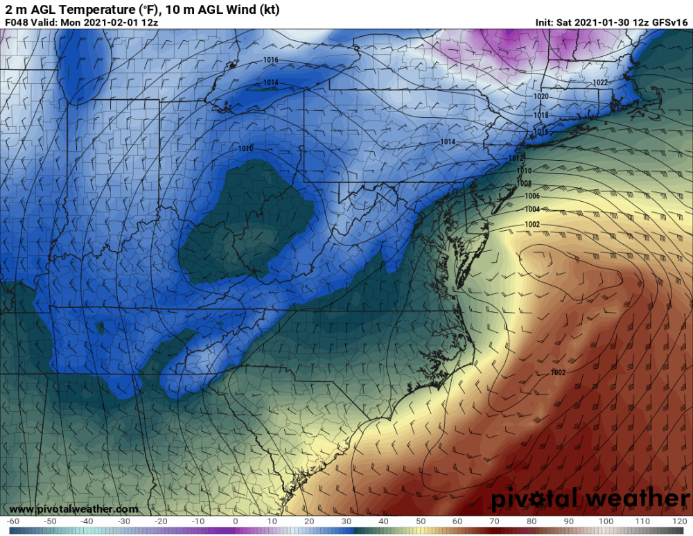
-
Jan 31 - Feb 1 Event - STORM MODE THREAD
Hypothetical 240 hour snow replied to stormtracker's topic in Mid Atlantic
I will take that CCB placement in the Euro, low gets tucked in closer to the coast, though... a more obvious dry slot and a bit warmer overall. Probably a period of drizzle/freezing drizzle (depending how cold the surface is) around Monday AM. -
Jan. 31-Feb. 2 Miller B storm
Hypothetical 240 hour snow replied to LVblizzard's topic in Philadelphia Region
UKMET can be discarded this cycle it appears. -
Jan 31 - Feb 1 Event - STORM MODE THREAD
Hypothetical 240 hour snow replied to stormtracker's topic in Mid Atlantic
UKMET a big outlier at this point... likely can be thrown out. -
Jan. 31-Feb. 2 Miller B storm
Hypothetical 240 hour snow replied to LVblizzard's topic in Philadelphia Region
I would guess PHI expands watches NWrd with the overnight package... At least up to I-78... could justify up to their northern border, but they may not go that far. -
Jan 31 - Feb 1 Event - STORM MODE THREAD
Hypothetical 240 hour snow replied to stormtracker's topic in Mid Atlantic
Definitely a case of localized excitement -
Jan 31 - Feb 1 Event - STORM MODE THREAD
Hypothetical 240 hour snow replied to stormtracker's topic in Mid Atlantic
I assume no one trusts the ICON thermals? -
Jan 31 - Feb 1 Event - STORM MODE THREAD
Hypothetical 240 hour snow replied to stormtracker's topic in Mid Atlantic
Wait for the EPS. -
Jan 31 - Feb 1 Event - STORM MODE THREAD
Hypothetical 240 hour snow replied to stormtracker's topic in Mid Atlantic
To my amateur eyes... this Euro run looks like a better H5 setup for a capture nearer to the coast? -
Jan. 31-Feb. 2 Miller B storm
Hypothetical 240 hour snow replied to LVblizzard's topic in Philadelphia Region
What do you all think for South-Central NJ (near Mount Holly)? My sister is supposed to get vaccinated at the South NJ mega site (in Glouchester county) Monday AM, and she is worried about snow impacting her trip to that site. -
Jan 31 - Feb 1 Event - STORM MODE THREAD
Hypothetical 240 hour snow replied to stormtracker's topic in Mid Atlantic
For a broad area forecast I think 4-8, is a good total given that unless the transfer happens really early and the isentropic ascent falls apart, 2-4 from the WAA regime looks guaranteed. Then get another 2-4 from showers associated with the ULL. That basically leaves the Def Band moderate-heavy snowfall out of the equation, which would obviously bump up totals in favored areas... but that band is going to be narrow with some subsidence likely flanking it so putting that explicitly in the totals when we are only partially in the mesoscale model window (and not really in the CAM window) is risky. -
Jan 31 - Feb 1 Event - STORM MODE THREAD
Hypothetical 240 hour snow replied to stormtracker's topic in Mid Atlantic
Given that the event-start is within 48 hours I see no way watches don't go up with the afternoon package, probably for all CWAs of interest in this sub. Yeah there is certainly some potential for only advisory amounts if the suppressed solutions verify and the CCB misses SE but converting watches to advisories is perfectly fine for the NWS. -
Jan 31 - Feb 1 Event - STORM MODE THREAD
Hypothetical 240 hour snow replied to stormtracker's topic in Mid Atlantic
I just want the Euro to stop the suppression trend it has had for like the last 24 hours... even if it doesn't come in line with the better captures depicted by the other guidance, if it at least stabilizes near where it was, it would at least make the lower end cut-off a little clearer for this event. Because if it keeps trending more suppressed the floor on this event would be pretty low for anyone NW of I-95 (and maybe even near I-95, depending on how certain we think the initial WAA thump will be given the transfer in progress and the antecedent dry airmass). -
Jan 31 - Feb 1 Event - STORM MODE THREAD
Hypothetical 240 hour snow replied to stormtracker's topic in Mid Atlantic
UKMET coming in hot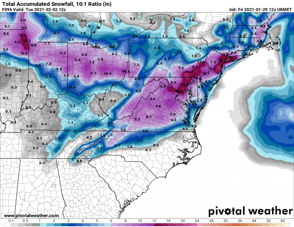
-
Jan 31 - Feb 1 Event - STORM MODE THREAD
Hypothetical 240 hour snow replied to stormtracker's topic in Mid Atlantic
The NAM typically models the low-lvl CAD better, and sometimes can catch onto a stronger LLJ advecting in a warm nose aloft (it did well in diagnosing the sleet storm that impacted SE PA in December that a lot of the other guidance didn't handle well)... but it can also be overdone in this LLJ at times... it did this in the warm christmas heavy rain event. -
Jan 31 - Feb 1 Event - STORM MODE THREAD
Hypothetical 240 hour snow replied to stormtracker's topic in Mid Atlantic
Yeah so I guess the consensus is the CMC can't be trusted unfortunately, the EC solution where the band sets up further SE seems more plausible. -
Jan 31 - Feb 1 Event - STORM MODE THREAD
Hypothetical 240 hour snow replied to stormtracker's topic in Mid Atlantic
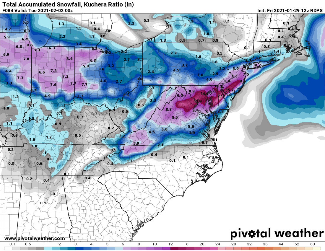
RGEM has over 2 feet in Central Delaware, with the Def band more or less stalled overhead lol... Do any pro mets think this scenario is plausible?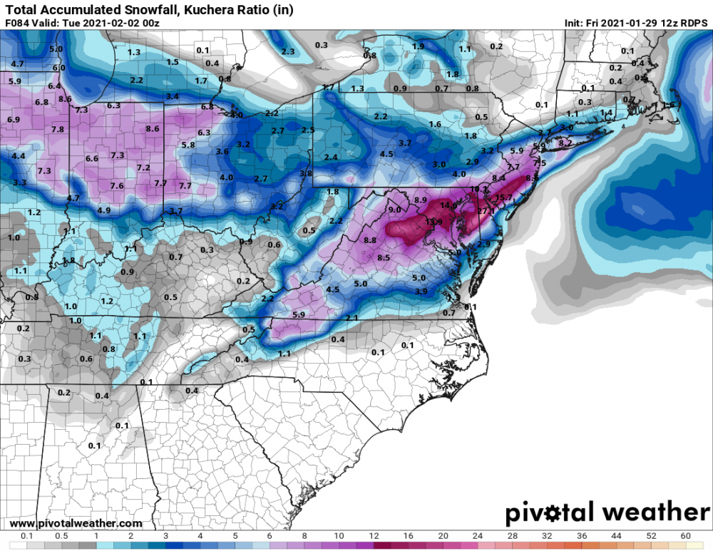
-
Everyone I-95 and NW needs to pray the bleeding stops with the 00Z suite
-
What does that mean for us around I-95?
-
I would guess that 0.5qpf is more of a function of spatial averaging done to arrive at the ensemble mean, some members are going to have the band placement in different locations etc. There is no way the max water totals where the def band sets up will be that low. Although it is more relevant for CAMs (because warm-season convection is smaller scale and generally more spatially heterogeneous).. probability matched mean is a better tool in instances like this where the placement of discrete features comes into play.