.jpg.7212c88cd7a6ee918250d4a9d2a8d183.jpg)

Chicago916
-
Posts
207 -
Joined
-
Last visited
Content Type
Profiles
Blogs
Forums
American Weather
Media Demo
Store
Gallery
Everything posted by Chicago916
-
Winter 2023/24 Medium/Long Range Discussion
Chicago916 replied to Chicago Storm's topic in Lakes/Ohio Valley
I've still got a feeling the first storm this weekend trends more NW to brush NIL with some moderate snows. That'll then have an effect on larger storm afterwards I would think? -
Winter 2023/24 Medium/Long Range Discussion
Chicago916 replied to Chicago Storm's topic in Lakes/Ohio Valley
It would be funny if it verified, but is the CMC trying to resolve a Mesolow over Lake Michigan due to the ULL next Friday? Would be a funny way to transition from near 60F Christmas to 6"+ snow cover on NYE. -
Serious question. What will happen to a MCS (if and when it congeals and moves into NIL) as it barrels into the lake breeze?
-
Lake breeze now evident along with the outflow. Once these collide... Boom.
-
North moving boundary extremely evident on satellite
-
2023 Short/Medium Range Severe Weather Discussion
Chicago916 replied to Chicago Storm's topic in Lakes/Ohio Valley
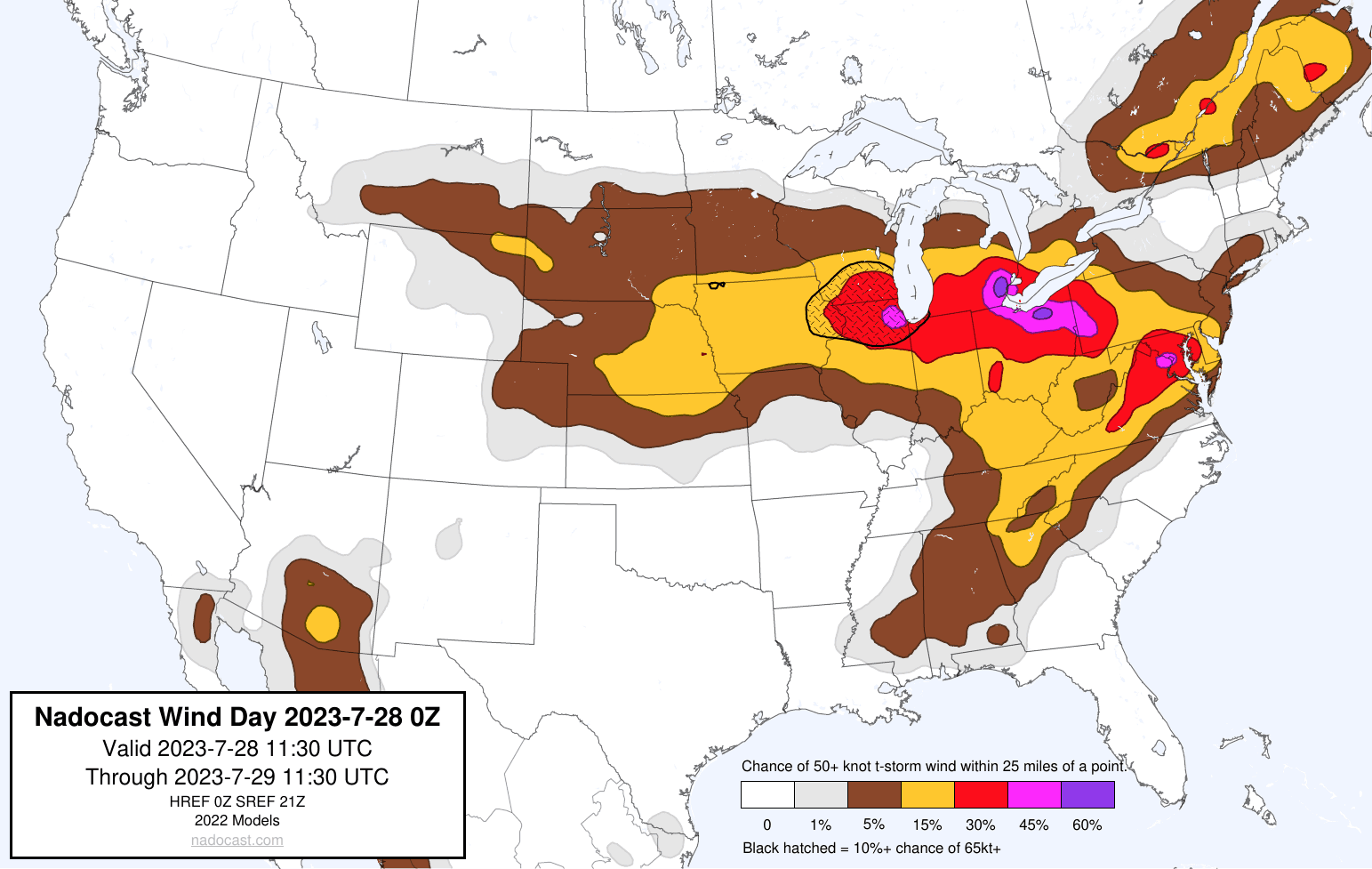
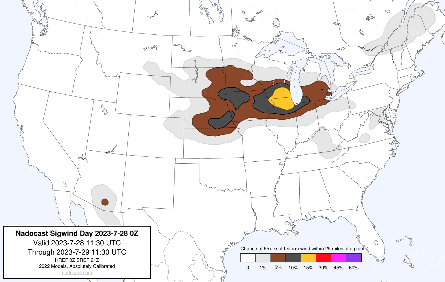
Not sure how well Nadocast does for wind, but definitely has that Derecho look for tomorrow.
-
Inb4 Northern Illinois supercells this afternoon.
-
And round 2 to follow still in Southeast Minnesota?
-
Latest 12z HRDPS showing a look similar to the Chicago double Derecho on June 30, 2014 except further east https://www.spc.noaa.gov/exper/archive/event.php?date=20140630
-
Repeat of today this Friday? Looks interesting at least
-
2023 Short/Medium Range Severe Weather Discussion
Chicago916 replied to Chicago Storm's topic in Lakes/Ohio Valley
Sirens just started in the city -
2023 Short/Medium Range Severe Weather Discussion
Chicago916 replied to Chicago Storm's topic in Lakes/Ohio Valley
Well a lot happened since my post this morning. Sheesh. Finally seeing filtered sunshine downtown Chicago. -
2023 Short/Medium Range Severe Weather Discussion
Chicago916 replied to Chicago Storm's topic in Lakes/Ohio Valley
If the MCS dies quicker, still decent potential for severe in NIL, but looks very conditional. 12Z HRRR for example. Will need to watch incoming CAMs to see if they follow, and observations. -
KORD office was riding the HRDPS and it looks like it performed very well with this
-
Looks like the European model was upgraded, including adding a lot of extended ensemble runs. Will be interesting to see how it performs!
-
He was a fantastic UIUC atmospheric sciences professor!
-
Tons of hail in Buffalo Grove right now. Ground is fully covered.
-
Long range 03z Rap popping some PDS Tor soundings in Chicago Wednesday morning. Something to monitor
-
Very late day 2 convective outlook.
-
Would be great if the RRFS comes back online soon in time for the upcoming severe event. Seems to be offline still since Friday
-
GFS trending in the direction to add to those
-
Has back to back high risks occured at this latitude within 5 days of one another before?
-
With how fast these storms are, that's a good idea.
-
Latest NWS Chicago update says you might be able to even sit tight in Naperville now that round 1 is more likely to be surface based FYI
-
Funny that a large blob of clouds is over the northern High Risk zone. That isn't going to affect the instability there?