HornetsHomer91
-
Posts
751 -
Joined
-
Last visited
Content Type
Profiles
Blogs
Forums
American Weather
Media Demo
Store
Gallery
Everything posted by HornetsHomer91
-
Mid to Long Range Discussion ~ 2022
HornetsHomer91 replied to buckeyefan1's topic in Southeastern States
Lord no …. Lol no threads till atleast 3-4 straight Runs of agreement imo -
Mid to Long Range Discussion ~ 2022
HornetsHomer91 replied to buckeyefan1's topic in Southeastern States
Yea ….. I’d love for anything else to be on Board at this point . Crazy it won’t budge though -
Mid to Long Range Discussion ~ 2022
HornetsHomer91 replied to buckeyefan1's topic in Southeastern States
Ik we shouldn’t bc It’s a surface map and Too far out but man that’s pretty …. Put a foot on Davidson… granted a lot of Sleet probably
-
Mid to Long Range Discussion ~ 2022
HornetsHomer91 replied to buckeyefan1's topic in Southeastern States
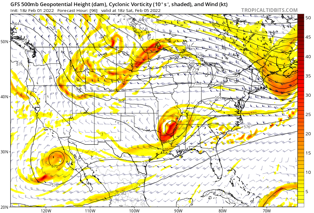
Out to the 108 now…. Open your tab for happy hour …. That 1037HP is now on MA/NY border Instead of Central Maine….. yep…. To 120 now, whole board gonna like this lmao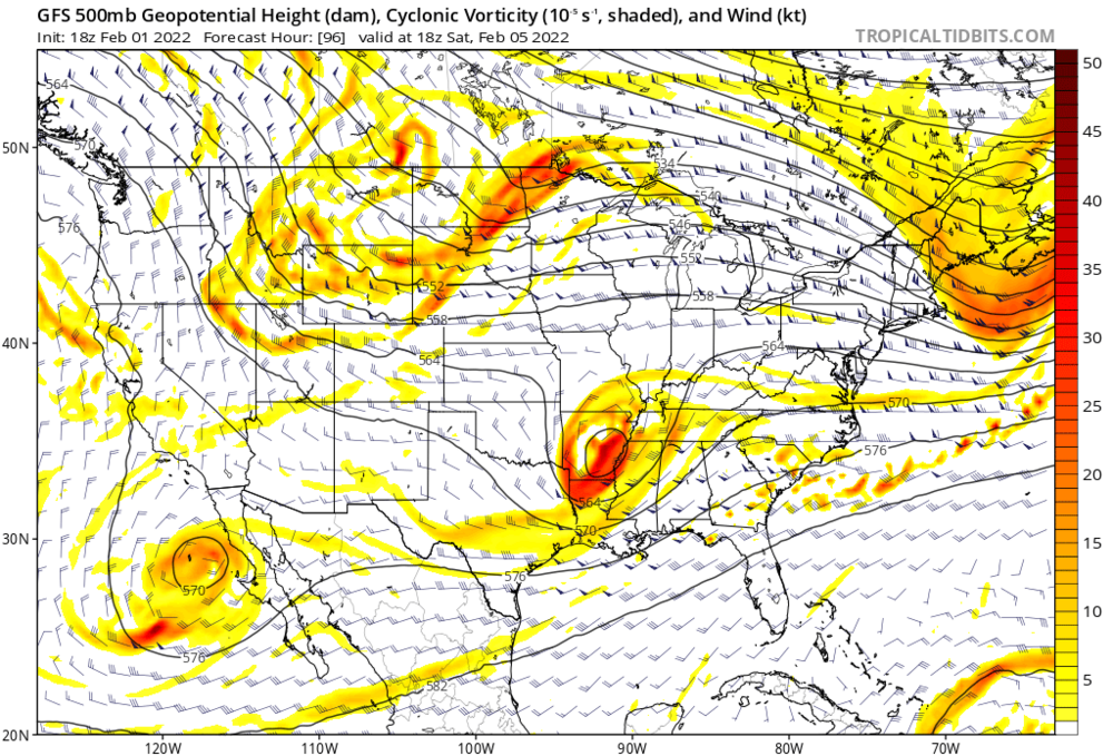
-
Mid to Long Range Discussion ~ 2022
HornetsHomer91 replied to buckeyefan1's topic in Southeastern States
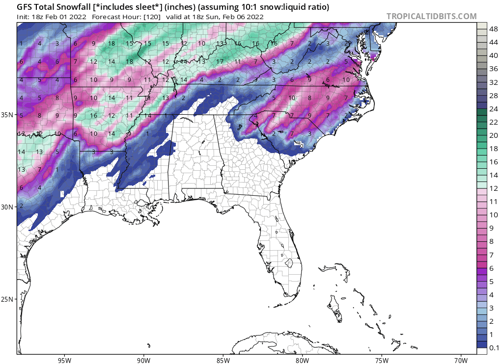
Not to toot my own horn or anything….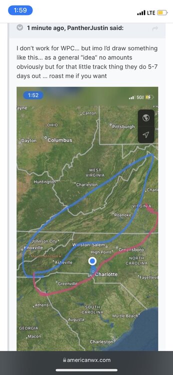
-
Mid to Long Range Discussion ~ 2022
HornetsHomer91 replied to buckeyefan1's topic in Southeastern States
This makes me happy…. I will be at Snowshoe next Friday thru 16th I saw the OP had some Below Zero’s up there 2 days -
Mid to Long Range Discussion ~ 2022
HornetsHomer91 replied to buckeyefan1's topic in Southeastern States
Agreed…. I look at Long range pattern recognition like a GFS happy hour Bombing…. If GFS showed us a Valentines Blizzard tonight no one would bat an eye, but you let it show a warm up 14 out and Holy hell it’s over guys pack it in -
Mid to Long Range Discussion ~ 2022
HornetsHomer91 replied to buckeyefan1's topic in Southeastern States
This isn’t towards you…. But as others have stated, we’ve been hearing for weeks now how it was gonna warm up in 3 weeks then 2 weeks then oh no 3 weeks again, rinse repeat…. I don’t believe that for a second the Long Range should always be looked at as Neutral until 10 days or so away bc of how many variables play into it -
Mid to Long Range Discussion ~ 2022
HornetsHomer91 replied to buckeyefan1's topic in Southeastern States
Also showed the GFS Mixed solution -
Mid to Long Range Discussion ~ 2022
HornetsHomer91 replied to buckeyefan1's topic in Southeastern States
Which would be 1/4” max… gotta take 75% off -
Mid to Long Range Discussion ~ 2022
HornetsHomer91 replied to buckeyefan1's topic in Southeastern States
No I completely agree it’s still there that’s all I was saying -
Mid to Long Range Discussion ~ 2022
HornetsHomer91 replied to buckeyefan1's topic in Southeastern States
Well 18Z GFS Op holds atleast…. 30-32 for all Along and N/W I-85 …but eventually Verbatim turns to rain as system pulls away for ALL of NC -
-
Mid to Long Range Discussion ~ 2022
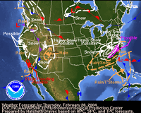
HornetsHomer91 replied to buckeyefan1's topic in Southeastern States
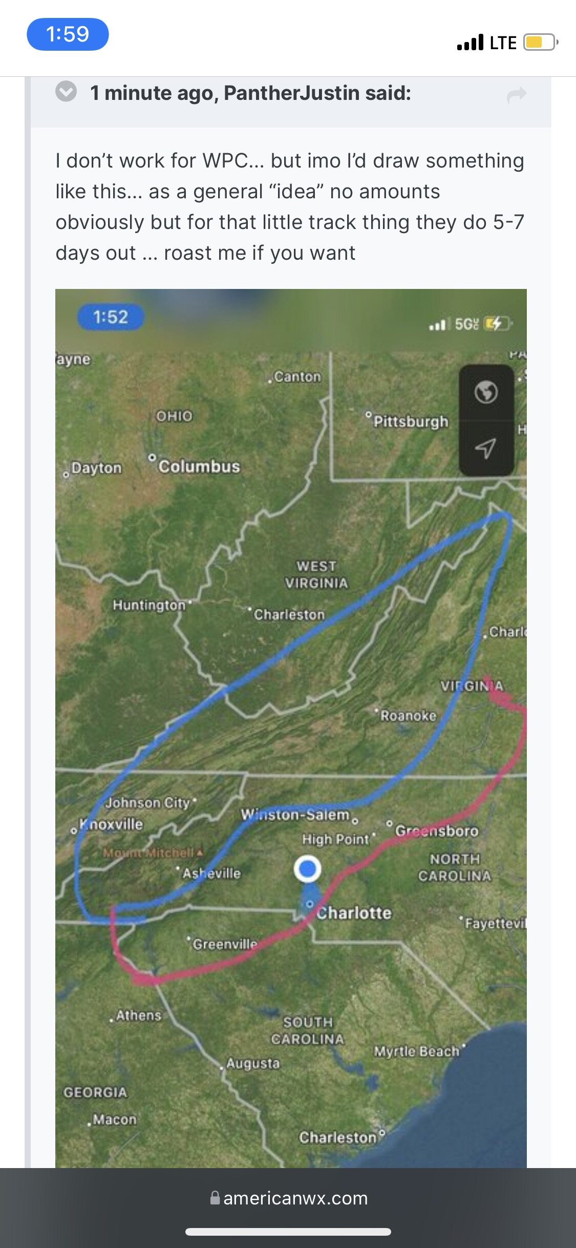
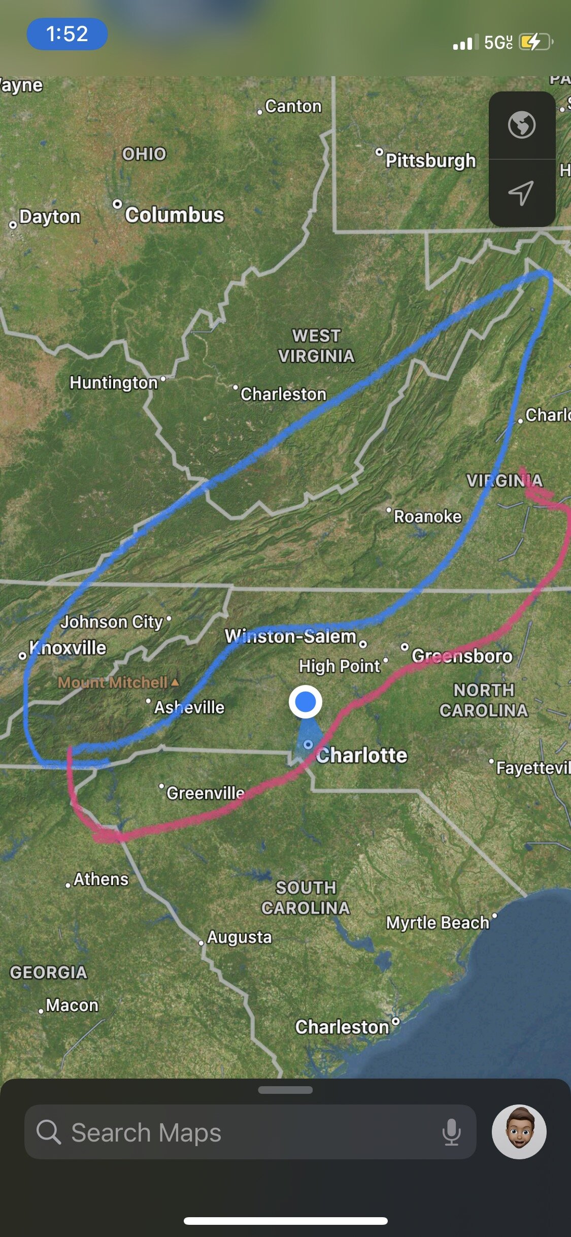
I don’t work for WPC… but imo I’d draw something like this… as a general “idea” no amounts obviously but for that little track thing they do 5-7 days out … roast me if you want …. Just for fun
-
Mid to Long Range Discussion ~ 2022
HornetsHomer91 replied to buckeyefan1's topic in Southeastern States
Very true…. Although not 100% it’s normally similar to UKMET … I’d much rather have UK/EURO ENS in my corner than GFS (it’s gotten better but it’s still goofus) everyone here wants to crown the GFS bc normally it shows us eye Candy we wanna see but that Jmo …. In A CAD scenario in NC I’d place any bet with anyone on NAM thermals, and normally take GFS/EURO mean and avg then slice by 40% to get a forecast -
Mid to Long Range Discussion ~ 2022
HornetsHomer91 replied to buckeyefan1's topic in Southeastern States
Wouldn’t the expansive Snowpack to our North create a Stronger HP than models could set up? Hybrid or not…. Also, I’d have to check but as much as we crap on the EURO imo it was decent last two events, Was first (even though it left it) to show further West Snow Accums 2 weeks ago, and this weekend it was first to go away from pure coastal QPF to the deform scenario…. Someone correct me if I’m wrong but that’s Jmo it bounces more than it used to but it’s not a clown model as some here may think -
Mid to Long Range Discussion ~ 2022
HornetsHomer91 replied to buckeyefan1's topic in Southeastern States
It would…. But same song and dance you likely cut 75% off W/E any model says for Ice imo … that verbatim would be widespread .1-.25 amounts no more -
Mid to Long Range Discussion ~ 2022
HornetsHomer91 replied to buckeyefan1's topic in Southeastern States
Bc it’s something to track -
Mid to Long Range Discussion ~ 2022
HornetsHomer91 replied to buckeyefan1's topic in Southeastern States
Feb 2022 Big Frostys revenge -
Mid to Long Range Discussion ~ 2022
HornetsHomer91 replied to buckeyefan1's topic in Southeastern States
Would also make sense coming off a slight warmup going back into a “Pattern” -
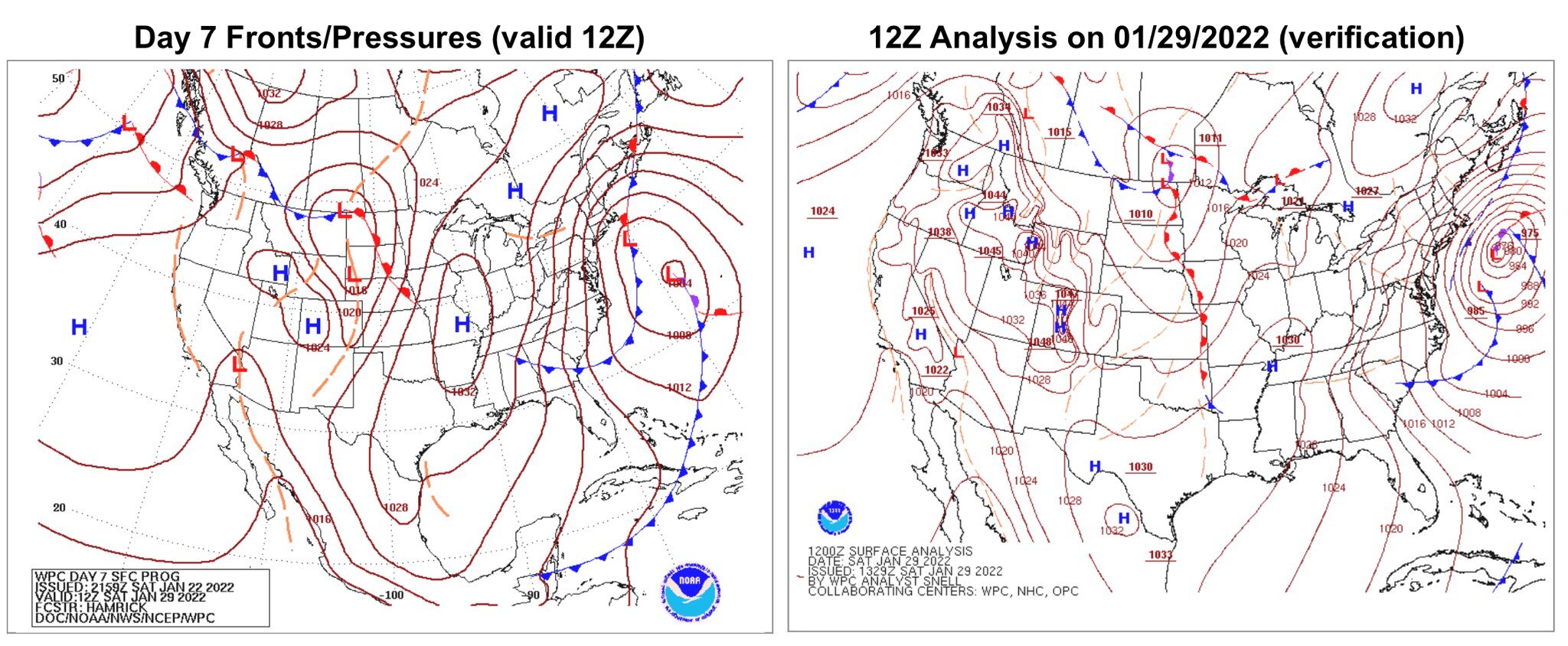
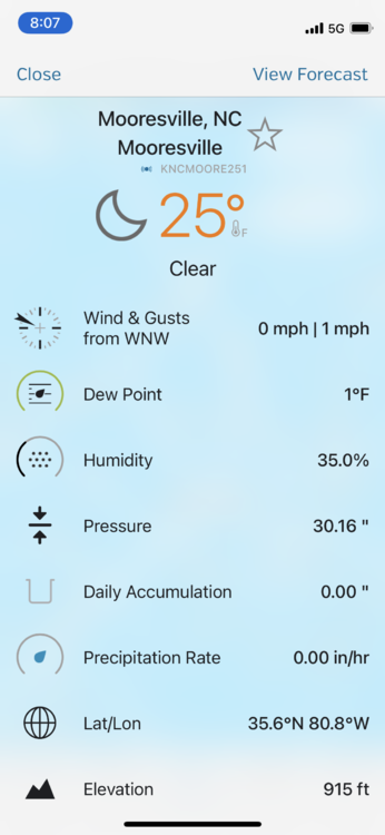
Potential 1/28-1/30 2022 winter storm
HornetsHomer91 replied to Prismshine Productions's topic in Southeastern States
Not bad for 7 days out WPC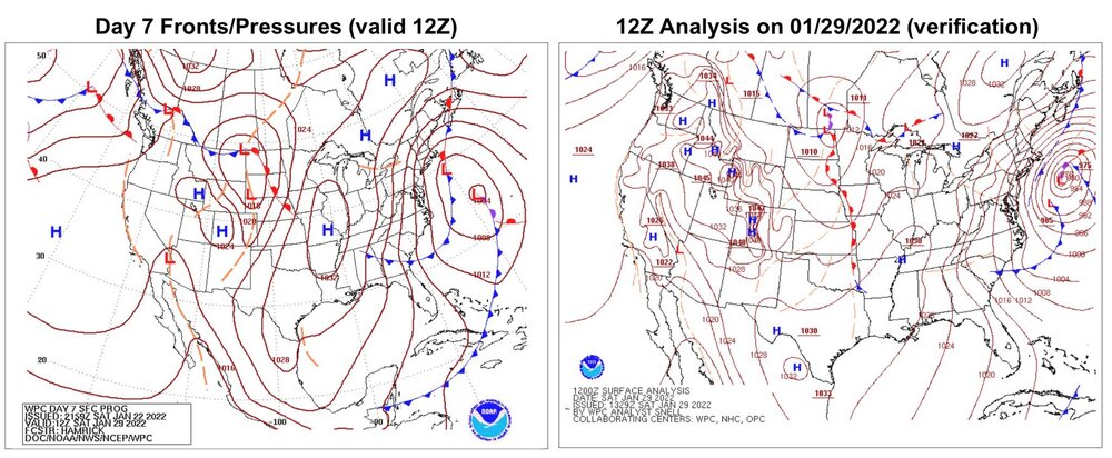
-
Im hoping to make it down to 10 -12 tonight but Idk if I will make it
-
Mid to Long Range Discussion ~ 2022
HornetsHomer91 replied to buckeyefan1's topic in Southeastern States
Ik we’re just looking at signals but that’s a much more realistic signal imo… than some Blitzing snowstorm. It’s consistently shown a classic CAD signal in that time period for awhile now -
Mid to Long Range Discussion ~ 2022
HornetsHomer91 replied to buckeyefan1's topic in Southeastern States
Wouldn’t 2022 without a weekend storm Tarheel -
Mid to Long Range Discussion ~ 2022
HornetsHomer91 replied to buckeyefan1's topic in Southeastern States
Wouldn’t that technically be the same storm that’s been showing up?