HornetsHomer91
-
Posts
751 -
Joined
-
Last visited
Content Type
Profiles
Blogs
Forums
American Weather
Media Demo
Store
Gallery
Everything posted by HornetsHomer91
-
What has happened to him? He used to be a giant Weenie now he just takes a dump all over everything. I swear everything could be showing a foot and he’d still say “meh N if I-40 maybe a slushy inch I’m just not seeing much else”
-
not trying to be this guy .... but it’s 48/22 here in LKN .... either we put the brakes on the sun or maybe just go grab a cooler and hit the lake
-
I don’t understand models looked better and they took my 1” away ?? (Iredell) what am I missing? Even the garbage NAM was showing some love ..... Also It’s 26 here and clear. Can we make a deal and get those clouds in here all ready?
-
Here’s the real question..... if the tables were turned and EURO/RAP/HRR/ICON ect ect were all showing warm nose but NAM was alone and showing your dream snow scenario would the forum hug it? If not why bother worrying in this current scenario
-
Yea, even 100-150 to your North up 85 I’m hoping we get cloud cover Tomm and don’t shoot up to mid 50s like last week
-
So we’ve got the Mighty team of ICON/RAP/HRRR in our corner lmao “Superteam”
-
Congrats Cincinnati
-
That does look better for CLT metro atleast lol
-
That just doesn’t make any sense and I’m not even trying to be a weenie. If it does someone explain how
-
Ik it’s 24-30hrs out yet....Can someone now cast and see which Model is verifying closest to reality? I’d do it myself but I’m driving and listening to Hornets game lol
-
This is true lol
-
What’s so wrong with this? still get 2-3” verbatim along and NW of 85
-
Pretty interesting
-
I always like NAM thermals in CAD , but it’s about worthless imo with anything else
-
The ICON is a model A snow Weenie made in their moms basement apparentlY
-
Or to civilization if we get that 20” Snow followed by 1” of ICE and temps below Zero either way I’m fine with it
-
You could just go ahead and copy this for next Sunday and Next week too lmao
-
The drastic swings need to be ignored sure over a 3suite constant if it goes 25 miles or so each time sure...... but 100 miles NW in one swing.... nah I wouldn’t buy that even if it swung in my favor. Everyone RELAX lol
-
Nah that’s a bit too much of a sudden it jump it will come back
-
wanting to try my hand at some map making for this, anyone know any cool websites make graphics? Or simply draw on a map? Sorry if this doesn’t fit here
-
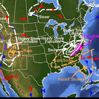
I’m not sure anyone East of an imaginary line of Asheville(I-40)- Winston/GSO (I-40)- Hwy220 up to ROA gets more than D-2” event at most but that’s Jmo. West Jefferson NC - Wythville VA will be winner if I’m making Predictions .....(5-8”) for someone in that Area but no one will score more than that imo
-
-
May have to buy a horse and cowboy hat and head up to Love Valley
-
Exactly. It’s so annoying to see them cry unless it’s some world shattering event
-
I was feeling good in Iredell about 4hrs ago lol yea onto next week I guess. I guess we could hope for a lesser system that’s just not as strong to stop the NW Trend