HornetsHomer91
-
Posts
751 -
Joined
-
Last visited
Content Type
Profiles
Blogs
Forums
American Weather
Media Demo
Store
Gallery
Everything posted by HornetsHomer91
-
February 18-19 MAJOR Ice Storm Threat
HornetsHomer91 replied to NorthHillsWx's topic in Southeastern States
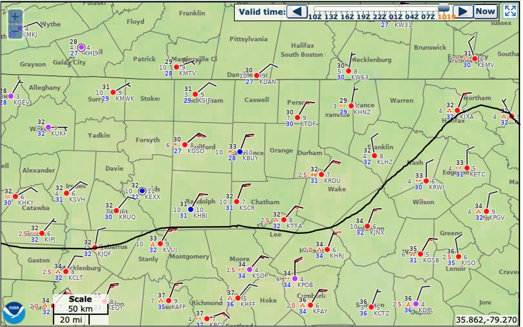
I like Brad and IK he’s just trying to “Calm the Nerves” of Meck Ppl but this is false. Everywhere around him is 30/31 in Iredell/Rowan/Parts of Lincoln/N Meck -
February 18-19 MAJOR Ice Storm Threat
HornetsHomer91 replied to NorthHillsWx's topic in Southeastern States
Absolutely horrible. It’s insane how they can be so far off .... we may as well just go back to checking barometric pressure and guessing off a telegram sent from DC -
February 18-19 MAJOR Ice Storm Threat
HornetsHomer91 replied to NorthHillsWx's topic in Southeastern States
Yikes.... guess that band warmed you? -
February 18-19 MAJOR Ice Storm Threat
HornetsHomer91 replied to NorthHillsWx's topic in Southeastern States
“HWY73 Cutoff”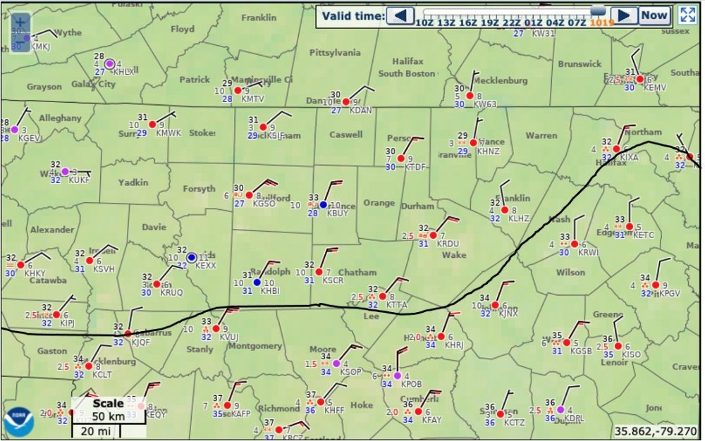
-
February 18-19 MAJOR Ice Storm Threat
HornetsHomer91 replied to NorthHillsWx's topic in Southeastern States
31.6/31 here In Mooresville light Rain boy this thing looks awfully wimpy on Radar.... Light Glaze on Cars/Deck To have looked so bad the other day certainly looks soft today -
February 18-19 MAJOR Ice Storm Threat
HornetsHomer91 replied to NorthHillsWx's topic in Southeastern States
04z HRRR Initialized the LP about Pensacola it’s still about 50 Miles Due South of NOLA so that’s a good 100 -150 Miles too Far NE not sure if that means anything downstream or not -
February 18-19 MAJOR Ice Storm Threat
HornetsHomer91 replied to NorthHillsWx's topic in Southeastern States
Certainly looks Colder than the one he posted a couple hours ago. From 3-11A Counties N of Meck 30-32 .... Freezing line down on NC/SC border -
February 18-19 MAJOR Ice Storm Threat
HornetsHomer91 replied to NorthHillsWx's topic in Southeastern States
Yea I saw that lmao -
February 18-19 MAJOR Ice Storm Threat
HornetsHomer91 replied to NorthHillsWx's topic in Southeastern States
HRRR initialized Pretty much on the money this time. -
February 18-19 MAJOR Ice Storm Threat
HornetsHomer91 replied to NorthHillsWx's topic in Southeastern States
True, I guess as someone who’s still rather new.... What happens to cause the NW Shift back majority of the time? -
February 18-19 MAJOR Ice Storm Threat
HornetsHomer91 replied to NorthHillsWx's topic in Southeastern States
I understand, but what causes the 24hr swings? I mean should we just take the most southerly trend and push it back 50 miles even before guidance does? Basically I’m trying to understand what happened since 11 last night to cause it ..... is it as simple as Climo? -
February 18-19 MAJOR Ice Storm Threat
HornetsHomer91 replied to NorthHillsWx's topic in Southeastern States
I’ve been stuck at 35/36 clouds here now .... It’s right there though Troutman 33 -
Isn’t everything that same exact area? Lol
-
Isn’t everything on this forum a bust?
-
February 18-19 MAJOR Ice Storm Threat
HornetsHomer91 replied to NorthHillsWx's topic in Southeastern States
He basically said this warm nose is gonna be so strong it warms most to 33 but looking at the “Futurecast” it still had Iredell/Rowan/Catawba at 30-32 for a good chunk so I almost think he’s more so talking about CLT immediate -
February 18-19 MAJOR Ice Storm Threat
HornetsHomer91 replied to NorthHillsWx's topic in Southeastern States
You made it!! So Much for that EURO Run lmao -
February 18-19 MAJOR Ice Storm Threat
HornetsHomer91 replied to NorthHillsWx's topic in Southeastern States
36/27 Here in Mooresville Clear Skies still. I think we’re gonna make it to 30 -
February 18-19 MAJOR Ice Storm Threat
HornetsHomer91 replied to NorthHillsWx's topic in Southeastern States
Gotcha thanks! -
February 18-19 MAJOR Ice Storm Threat
HornetsHomer91 replied to NorthHillsWx's topic in Southeastern States
Seeing Reports of 32 and and IP/FRZN (I doubt it’s Sleet) about 5 miles SE of Lafayette LA that’s DEEP South. 32 And FRZN Abbeyville LA Directly On Gulf Coast. My point is let’s start checking 18Z suite to see who had <32 that far south..... Basically I-10 Corridor -
February 18-19 MAJOR Ice Storm Threat
HornetsHomer91 replied to NorthHillsWx's topic in Southeastern States
I love how Literally just about every Met I’ve seen someone post on here has Iredell/Catawba/Rowan area anything from All Rain/ Glaze - .1 / .1- .25/ GSP .3-.5 I mean hey.... one of them has to be right I guess -
February 18-19 MAJOR Ice Storm Threat
HornetsHomer91 replied to NorthHillsWx's topic in Southeastern States
44/25 in Mooresville not sure what I was Shown on NAM currently. I still stick with my idea the Ice line will halt on HWY73 up to HWY152 somewhere in there South of there I doubt goes below 32/33 at all N of there 31/32 Includes Huntersville- Concord/Kannapolis up To China Grove - Mooresville ..... Point blank you all know your area and how it performs in CAD , If you normally hold longer you will tonight as well if not you won’t. Climo and history will repeat itself more times than not. Someone tell me if I’m wrong on that though -
February 18-19 MAJOR Ice Storm Threat
HornetsHomer91 replied to NorthHillsWx's topic in Southeastern States
Everyone relax -
February 18-19 MAJOR Ice Storm Threat
HornetsHomer91 replied to NorthHillsWx's topic in Southeastern States
This isn’t FT Worth or Slidell LA we gotta tread a fine line or it’s no fun come on -
February 18-19 MAJOR Ice Storm Threat
HornetsHomer91 replied to NorthHillsWx's topic in Southeastern States
No way..... CAD is normally Better than Modeled. I would Think Anyone North of HWY73/152 will be just fine as far as Cold those areas always stay Colder longer. -
February 18-19 MAJOR Ice Storm Threat
HornetsHomer91 replied to NorthHillsWx's topic in Southeastern States
Not that it matters .... but I’m still at 35/22 Forecast high was 45-47 ... idk