HornetsHomer91
-
Posts
751 -
Joined
-
Last visited
Content Type
Profiles
Blogs
Forums
American Weather
Media Demo
Store
Gallery
Everything posted by HornetsHomer91
-
2021-2022 Fall/Winter Mountains Thread
HornetsHomer91 replied to BlueRidgeFolklore's topic in Southeastern States
That Deform back west in GA looks Pretty good for you guys in the hills idk how Far East it will pivot for us CLT guys but looks good for you all… idk how you wouldn’t get another 2-3” if you get under it -
January 16-17, 2022 MLK storm obs/now cast
HornetsHomer91 replied to George BM's topic in Mid Atlantic
I’m a SE Poster …. But just as a heads up for you all…. I’m 30 miles N of Charlotte…. Last nights HRRR nailed it…. I’ve yet to switch to FRZN and I’m at 24 degrees still about 4” of SN/IP on ground it was alone last night showing this scenario while everything else had cut me down to at most an inch or so. Idk if same will play out for you all but goodluck down the line! Reel it in and let’s bring the big one next Weekend -
Winter Storm Izzy Obs Thread
HornetsHomer91 replied to Prismshine Productions's topic in Southeastern States
For those in CLT metro area ….. still got a couple hours but 3-4” lines up with HRRR from yesterday
-
Mid to Long Range Discussion ~ 2022
HornetsHomer91 replied to buckeyefan1's topic in Southeastern States
Yea more than a 7/8 BIG BIG DOGS in there for 90% of this Forum very impressed. -
Winter Storm Izzy Obs Thread
HornetsHomer91 replied to Prismshine Productions's topic in Southeastern States
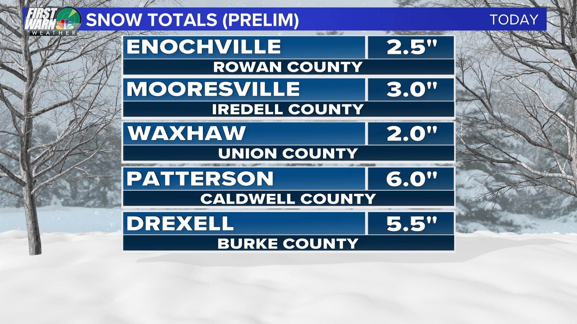
Probably 1/2” or So here in Mooresville picking up a bit now…. 24/22 so about to bottom out -
Winter Storm Izzy Obs Thread
HornetsHomer91 replied to Prismshine Productions's topic in Southeastern States
You should come 40 miles North…. We’re covered that’s insane the difference only 40 miles makes -
Winter Storm Izzy Obs Thread
HornetsHomer91 replied to Prismshine Productions's topic in Southeastern States
Anyone else very interested in the Deform later this afternoon? Someone in that is gonna get a quick 2-3” -
Winter Storm Izzy Obs Thread
HornetsHomer91 replied to Prismshine Productions's topic in Southeastern States
I-85 …. Climo wins very nice! -
Winter Storm Izzy Obs Thread
HornetsHomer91 replied to Prismshine Productions's topic in Southeastern States
Too early to say HRRR scored again? I don’t remember Saluda/Greenwood having much of a shot before last eve…. By the way snowing here in Mooresville 31 degrees -
Winter Storm Izzy Obs Thread
HornetsHomer91 replied to Prismshine Productions's topic in Southeastern States
Does anyone have the current soil temps? -
2021-2022 Fall/Winter Mountains Thread
HornetsHomer91 replied to BlueRidgeFolklore's topic in Southeastern States
Ik it was posted in main thread…. But the low looks to be Way down over Mobile Bay/Pensacola…. HRRR at current time had The Low up around Selma/Montgomery AL…. Umm that’s a tad off unless I’m looking at it wrong (I am new) but if I’m not the Hrrr initialized about 50 miles too far N than the surface …. What that means for us later is TBD but interesting to me -
Winter Storm Izzy Obs Thread
HornetsHomer91 replied to Prismshine Productions's topic in Southeastern States
34/25 here in Mooresville -
Getting ready to Bring the pain In CLT Metro …. Hope y’all got a Generator
-
Shame it doesn’t just continue and exit off Jekyll Island GA then turn up lol
-
Honestly why wouldn’t they? If it were me I’d keep pumping the ICE train even if I knew it was trending away from it ppl aren’t gonna roast you if you bust too low on SN totals, they’ll rip you apart if you start saying less Ice more SN. Just throw a 2-4” and 1/4-1/2” accum map out and let it rise at this point lol
-
Mid to Long Range Discussion ~ 2022
HornetsHomer91 replied to buckeyefan1's topic in Southeastern States
Hopefully ensembles back it up -
Mid to Long Range Discussion ~ 2022
HornetsHomer91 replied to buckeyefan1's topic in Southeastern States
Exactly, if you could move this 100-150 Miles NW and still have snow you’re probably in a good spot lol -
Maybe Uptown down towards Pineville/East Side towards Monroe but nowhere South or University imo ….HWY73 Along and N is the battleground most times
-
If we Beat Duke today in Cameron idc if all my trees come down I will be happy
-
2-4” of SN/IP 1/10-1/4” ice that area Winston/MT Airy/Up to VA Border always over performs
-
2021-2022 Fall/Winter Mountains Thread
HornetsHomer91 replied to BlueRidgeFolklore's topic in Southeastern States
Dang, very nice jump agreed WNCSnow -
What kind of idiot made this? It looks like a Kindergarten Art project …. Like all of his work
-
Winter Storm Izzy Obs Thread
HornetsHomer91 replied to Prismshine Productions's topic in Southeastern States
40/28 here in Southern Mooresville NC (30 miles N of CLT) -
Mid to Long Range Discussion ~ 2022
HornetsHomer91 replied to buckeyefan1's topic in Southeastern States
A winter win would be 2-4 2-4” events or 2 4-6” events imo something in the 8-12” season total range -
2021-2022 Fall/Winter Mountains Thread
HornetsHomer91 replied to BlueRidgeFolklore's topic in Southeastern States
Isn’t it sustained >25 for 24hr or is that just down here in Piedmont? That may be wrong too though