ineedsnow
-
Posts
22,753 -
Joined
-
Last visited
Content Type
Profiles
Blogs
Forums
American Weather
Media Demo
Store
Gallery
Everything posted by ineedsnow
-

Hoisting the Sultan Signal: Heavy Rain Event July 5-7
ineedsnow replied to WxWatcher007's topic in New England
didn't even see your post.. either its drunk or someone floods -
Hoisting the Sultan Signal: Heavy Rain Event July 5-7
ineedsnow replied to WxWatcher007's topic in New England
12z HRRR going wild in some spots -
Beautiful out!! Cloudy and cool.. windows open
-
Hoisting the Sultan Signal: Heavy Rain Event July 5-7
ineedsnow replied to WxWatcher007's topic in New England
Think later this afternoon and tonight will be wild for some -
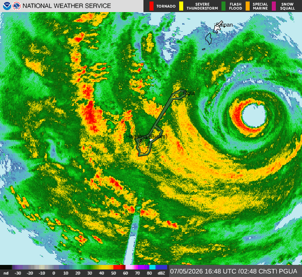
BULLETIN - EAS ACTIVATION REQUESTED Extreme Wind Warning National Weather Service Tiyan GU 629 AM ChST Mon Jul 6 2026 The National Weather Service in Tiyan has issued a * Extreme Wind Warning for... Rota... * Until 915 AM ChST. * At 629 AM ChST, Doppler radar indicated catastrophic winds associated with eyewall passage of Super Typhoon Bavi (09W) approaching from the east, are imminent over the entirety of Rota. THIS IS AN EXTREMELY DANGEROUS AND LIFE-THREATENING SITUATION! TAKE COVER NOW! Venturing outside can result in DEATH from flying projectiles. Unreinforced structures will be destroyed. Utility poles and associated power lines will be down, posing a risk to life. DO NOT VENTURE OUT INTO THE RELATIVE CALM OF THE EYE AS IT PASSES OVER THE AREA. Extreme winds will soon return on the back side of Super Typhoon Bavi. * Locations impacted include... Sinapalo, Songsong, Annex F, Tenetu, I Chenchon, Liyu, Ginalangan (Chudan), Taimama, Tatgua, Matpo, Gampapa, As Niebes (Nieves), Talo, Makmak, Agatasi (Payapai), Lempanai, Gayaugan (Kaan), Gagani, Mananana and Finata. PRECAUTIONARY/PREPAREDNESS ACTIONS... Widespread destructive winds in excess of 150 mph are expected. TAKE COVER NOW! Treat these imminent extreme winds as if a tornado was approaching and move immediately to the safe room in your shelter. Take action now to protect your life!
-
Hoisting the Sultan Signal: Heavy Rain Event July 5-7
ineedsnow replied to WxWatcher007's topic in New England
.thumb.png.deb46c344cba2d0582189708c8f43a99.png)
.thumb.png.129225d8c1e464b2c2ed2c1e28b9b507.png)
-
3k mostly gets CT
.thumb.png.17b20dbc6d868abdd2a63b93d887cbe8.png)
.thumb.png.e25704376bc998368ae1696eadbe4743.png)
-
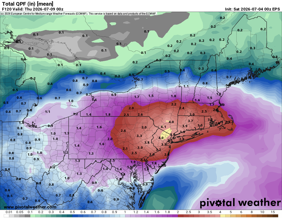
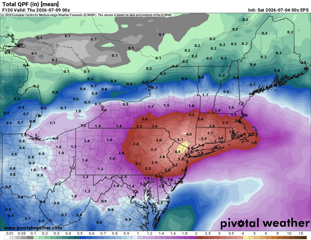
18z NAM gets alot of SNE with 3 plus
-
we wish we were here
-
12k NAM gone wild over Mt Tolland

-
ICON EPS is pretty nuts though.. but it is the ICON Eps lol over 6 is very impressive for a mean..
.thumb.png.a84f912c4260bd75808463dbd6ac6bf0.png)
-
I have Monday and Tuesday off.. if its bad enough I might have to take a drive to check it out
-
EURO also with a big flood threat.. someone will get crushed
-
For a day then cools back down.
-
Ummm no.. you got this week.. Lucky guess? but looks average with some below and some above normal temps
-
Models going to be all over.. but someone will flood
-
18z ICON
.thumb.png.4fe21ea2ea0949aee7130e62c23f74f4.png)
-
18z NAM gone wild
-
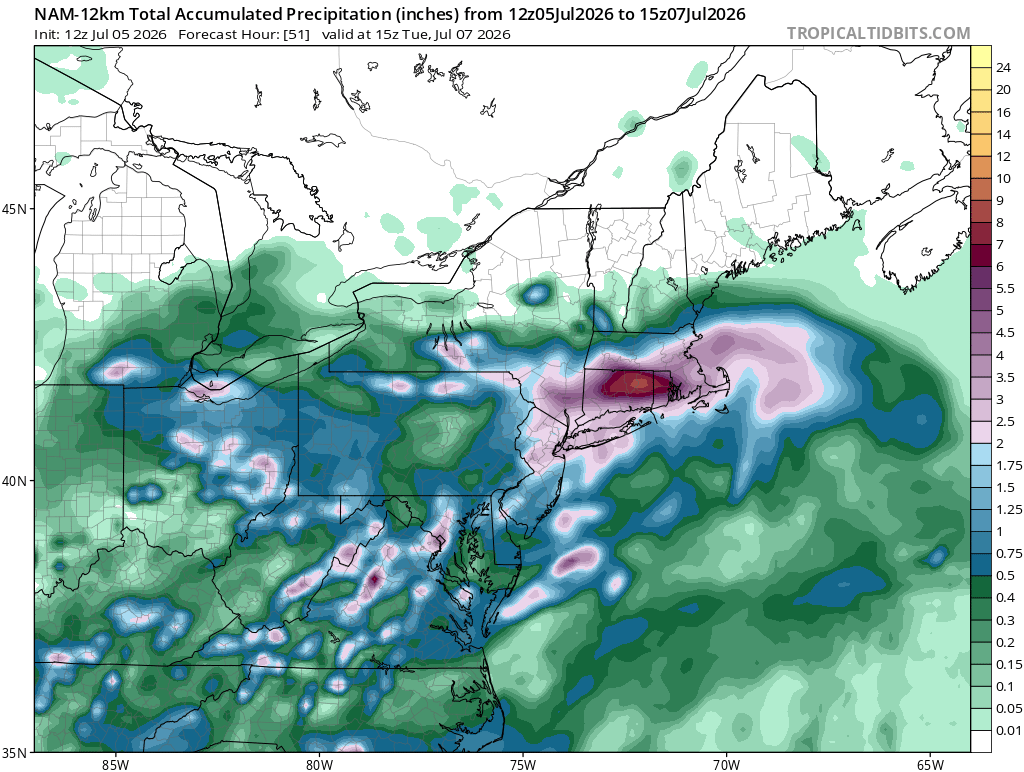
12z Euro floods @Damage In Tolland
-
Pretty high amounts on the EPS.. good sign someone is going to get crushed
-
CMC GFS and Euro flood early this coming week
-
looks much much better now
-
Could hit a island or Taiwan.. it would be nice to get a peak then.. btw for being a cat 5 right now satellite looks meh compared to what we usually see
-
160 mph now cat 5

.png.0fab81653c52e4b2f213eff029b9eb0c.png)
.png.41a5cfb78eca3d4416ed961e624f6658.png)
.png.b631c879cdfac97588cf05a7dd0e12d6.png)
.png.6f534afcbf8d43893e0ff47bf11d465d.png)

.png.299842805cec3d2372f6a465183123ea.png)
.png.0d0372b397efb656bcaa29508aeb0ce8.png)


.png.7961e6e1c31df24111a5d45a8d7ffabf.png)