

ineedsnow
-
Posts
22,757 -
Joined
-
Last visited
Content Type
Profiles
Blogs
Forums
American Weather
Media Demo
Store
Gallery
Everything posted by ineedsnow
-
 HREF is missing the rain coming through now
 -
crazy rain in westfield https://www.westfieldwebcam.com/
-
he wasn't wrong with what he said.. and trust me far from left but lets stick to weather
-
radar looks great for here.. hopefully it doesn't die out by the time it gets here
-
found a spot 14 on this map.. and yes I know it wont even be close for some that will say this is my call
.thumb.png.8d9871b0ab89a80c63d2637dd7f6c644.png)
-
I will! enjoy all those days and weeks with dews in the 70s.. even though if you only get one or two we all know you will spin it
-
no cool? what do you call the last couple weeks? dews near or over 70 for weeks? why didn't you tell us you moved to Florida?
-
I'll take the below average and dews in the 60s BTW July will end up close to average if not slightly below.. you still onboard for the hottest Summer ever?
-
storms forming in CT.. someone is going to get drenched today
-
talking to yourself again?
-
it was a coc day here.. drunk again? agenda driven? hottest summah ever getting to you?
-
65 is the highest around here congrats
-
dews have been in the 50s all day here.. just hit 60
-
Lol ya ill post it but in my heart I know its a long shot
-
6 is probably max for someone.. most should see 2 to 4
-
https://x.com/TheOfficialMrA1/status/2081805153083003059?s=20
-
we need that here
-
https://x.com/MaxVelocityWX/status/2081798308155060368?s=20
-
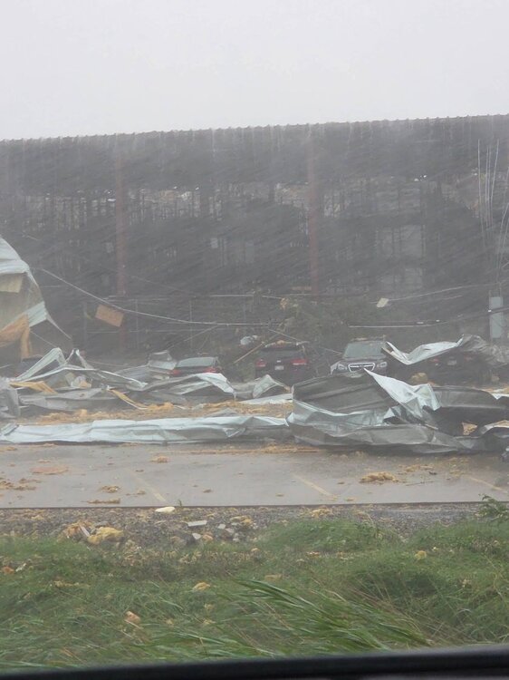
First one I've seen but im sure a bunch of bad ones will come in soon
-
Looks to have lifted now.. but appleton looks like it got nailed
-
Looks to be getting even stronger now
-
congrats @weatherwiz
.thumb.png.7d56199cb80d82dab57f7f6f8f6729d5.png)
-
NAM floods you down the CT river
-
12z NAM is wild for some
-
some will flood
.thumb.png.93e8b91b288417f70070a3682a18a028.png)


.png.7cbc1c2ac1060647836c5b396b418330.png)


.png.0c4e5d1bbc43d2904b5bcf1be503a77f.png)

.png.a505a0e4ce29d943af9b57aef9335ec9.png)