Spanks45
-
Posts
4,368 -
Joined
-
Last visited
Content Type
Profiles
Blogs
Forums
American Weather
Media Demo
Store
Gallery
Everything posted by Spanks45
-

May 2024 Discussion - Welcome to Severe Season!!!!
Spanks45 replied to weatherwiz's topic in New England
This current system, despite the wind and rain. My windows are open and I am still wearing shorts...the house actually feels muggy this time and quite frankly for the first time all Spring. So I have to agree, we are finally turning the page -
May 2024 Discussion - Welcome to Severe Season!!!!
Spanks45 replied to weatherwiz's topic in New England
We cleared out here just in the nick of time....
-
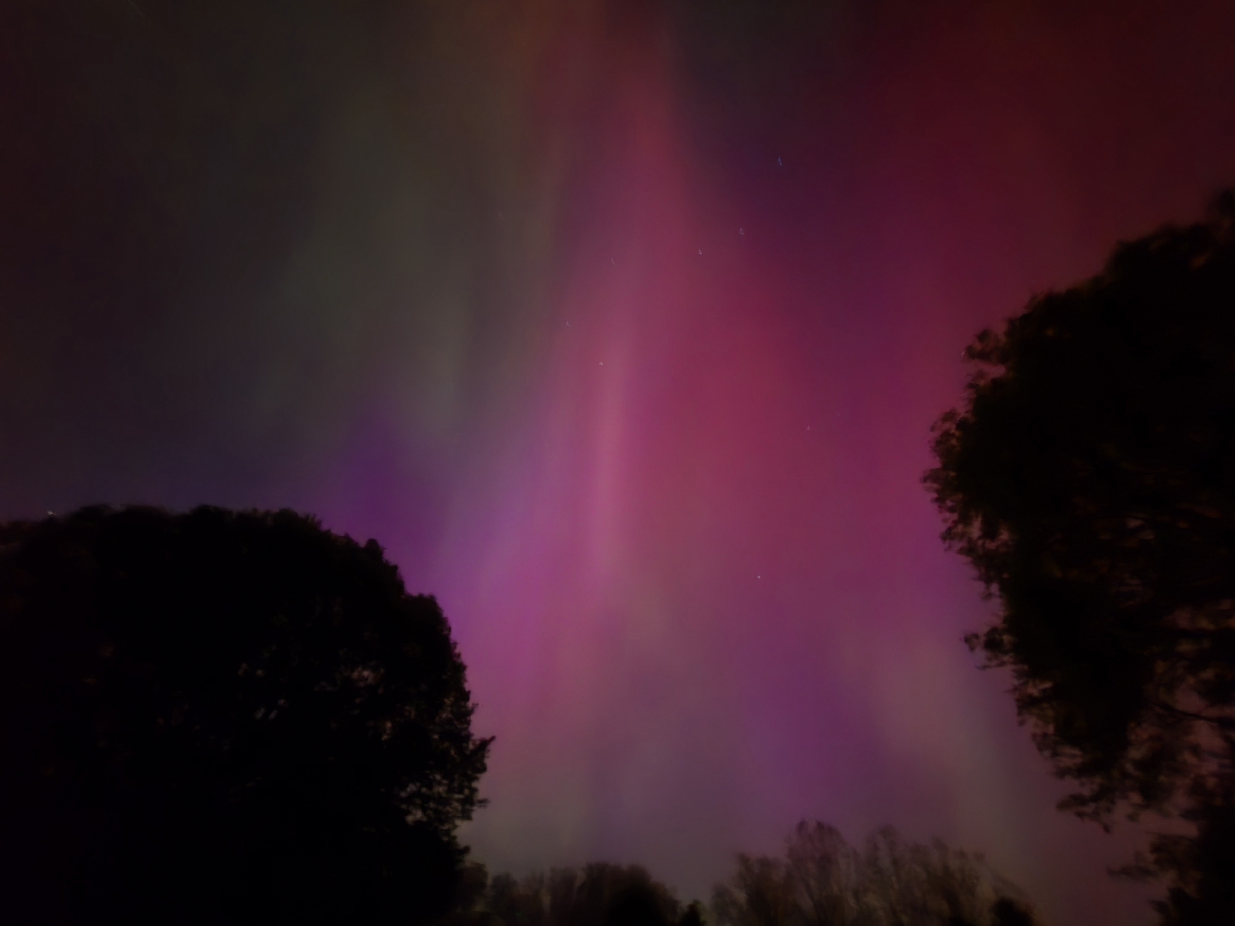
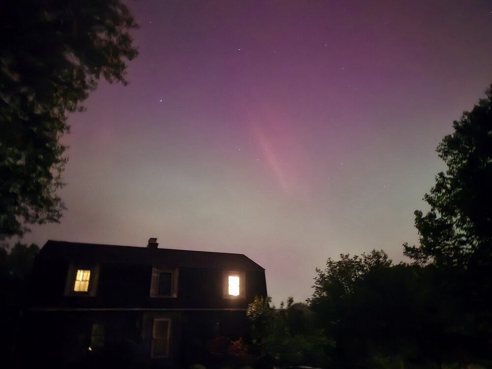
This was over my house....to the naked eye, you could see the colors and the white streak as well
-
The sky was pink and green and at time a deep red to the naked eye....I have personally never seen anything like it in my lifetime, you could see the pillars without any camera. The details were definitely pulled out using the camera.
-
Wow...4 seconds on my galaxy s24 ultra

-
May 2024 Discussion - Welcome to Severe Season!!!!
Spanks45 replied to weatherwiz's topic in New England
Hot and borderline humid here in SW CT....almost full sun as well 81⁰/68⁰ -
May 2024 Discussion - Welcome to Severe Season!!!!
Spanks45 replied to weatherwiz's topic in New England
It has certainly brightened over the past 10 minutes or so....impressive 0.92" of rain this morning 60/59 atm -
May 2024 Discussion - Welcome to Severe Season!!!!
Spanks45 replied to weatherwiz's topic in New England
Impressive rainfall rates with this last batch...has to be pushing an inch of rain this morning Seasons of rain continues it seems....I fully expect it to not rain from July to September, law of averages has to take over at some point, right? -
May 2024 Discussion - Welcome to Severe Season!!!!
Spanks45 replied to weatherwiz's topic in New England
1 crack of thunder, enough to wake me up and remind me that I have to take the dog out. Thankfully the heavy rain only lasted for 10 minutes. All the leaves and green this morning...the flora thinks the seasons have changed at least -
May 2024 Discussion - Welcome to Severe Season!!!!
Spanks45 replied to weatherwiz's topic in New England
Why can't every morning be like this? Clear skies, warm sun, no need for coats/jackets. 57⁰/52⁰ Definitely a top 5 morning out there....at least here -
May 2024 Discussion - Welcome to Severe Season!!!!
Spanks45 replied to weatherwiz's topic in New England
Within 10 minutes it went from mid spring to early summer...guess the front pushed through here -
May 2024 Discussion - Welcome to Severe Season!!!!
Spanks45 replied to weatherwiz's topic in New England
The 6z run of the GFS was pretty nasty....hopefully that doesn't come to fruition, I thought the Euro at least looked better. -
May 2024 Discussion - Welcome to Severe Season!!!!
Spanks45 replied to weatherwiz's topic in New England
yup, up to 76 degrees here....dare I say hot in the sun? -
Of course, while I was on vacation...no way to cover the fruit trees or other plants that decided to come up early...
-
No stick season down here....82⁰ and dare I say a bit sticky 56⁰ back at home
-
beat me to it....peaches are a week from dropping their flowers, apples are probably about a week from flowering
-
I hope not....but it has been happening every year recently. From extreme warm to cold in Spring, extreme enough to wipe out the fruit trees....unreal
-
33.3⁰ for the low here...looks like April returns tomorrow
-
Saw some cool clouds heading south from a Bball tournament in Westford today....
-
24.8⁰...no wonder the house was a bit chilly this morning, despite loading the wood stove before bed
-
Impressive shaking here...not sure if it was being in the valley, with sandy soil. But cabinet doors visibly moving. My pool with the cover on had water splashing all over. Pretty cool experience....
-
Significant Miller B Nor'easter watch, Apr 3rd-4th
Spanks45 replied to Typhoon Tip's topic in New England
It has been historically bad over the past couple of weeks ...at least 24+hrs out -
Go UConn! I see the forecast bumped up for tomorrow too, mid to upper 50s with sun. While not 70, it will still feel great
-
Yeah, still some sun here...temp has bounced to 70.4⁰
-
Sun most of the morning, skyrocketed to 65⁰. Looks like clouds are rolling back in now.