jculligan
-
Posts
391 -
Joined
-
Last visited
Content Type
Profiles
Blogs
Forums
American Weather
Media Demo
Store
Gallery
Everything posted by jculligan
-
Warm air managed to work its way in. We're up from 36F at sunset to 51F now. Incredibly balmy night out there.
-
Last winter was such a dud I often forget about this one. We only got 6" on the northern fringe of the storm here, but what a whopper from southern VT up into the Lakes region! That stationary death band was one of the more extreme cases of mesoscale banding I've ever seen - it was almost like watching a lake effect band in my old stomping grounds of western New York. Danbury NH picked up 48" of snow, and then a week later it was completely gone...
-
Incredible temperature ranges over very short distances this evening. This is the most extreme example I can find in New Hampshire: At my location, we had slipped back to 36F but have since spiked back to 44F which is now the high for the day.

-
Warm air struggling to reach this location today. Sometimes my elevation helps, but after briefly rising to 43F early this afternoon we have since settled back to 36F. We've been in and out of the fog for most of the day with an occasional undercast visible to the west. Temperatures could be interesting tonight, especially near/just after FROPA. Wind advisory hoisted for gusts to 50 after 3am.
-
Looks like we got about a half inch of slop here in Jackson. Currently 36F and OVC. Ready to move on to Saturday...
-
I've been down visiting the girlfriend in Malden MA these last couple of days, and about to make the trek back north to Jackson. Balmy 55-degree morning here in eastern Mass. Seeing a lot of 32F readings from Ossipee north. Hoping temps can creep up a degree or two before I get up there, but it looks like another classic CAD day in the MWN Valley.
-
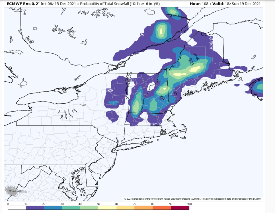
Yes, I'm feeling cautiously optimistic about finally scoring my first 6"+ event of the season with this one. Two weeks later than last year, but unlike last year...it looks fairly likely we'll keep whatever we get through Christmas.
-
6"+ snowfall probabilities on the Euro ensembles in the 24-hour period from 18z Saturday to 18z Sunday:
-
The December 5th storm (last year) completely hosed the valley. They didn't get any snow from that one. At my location, it was raining cat paws until about 4pm then eventually managed to snow 6" when temps dipped to 32F in the evening. The frequency of events has been way higher this year, but the magnitude of each event has been less with no 3"+ yet in my location. Heading north this morning. On the drive up 16 it'll be interesting to see if/where the snowpack held.
-
It's been very interesting comparing these last two seasons. The Mount Washington Valley is doing MUCH better with "snowpack" this early season compared to last year. Last year, the valley wasn't whitened for the first time until 12/17. This year, the valley has had snowcover since 12/2 and yesterday's 2" brought the snow depth up to about 5-6" right on the valley floor. Looking at the mesonet obs, it looks like they are still holding at 32F so doubtful there's been much melting yet. We don't have as much on the ground at 1500' so it'll be interesting to see if any of the snow has survived at that elevation when I arrive home tomorrow morning.
-
They have very, very limited snowmaking from what I understand. Last year they essentially blew snow for the rope tow to get the beginner's slope open and left the rest of the mountain at the mercy of the weather. As a result, they weren't really "open" until close to February 1st and ended up with a six-week season. Their south-facing exposure is great during arctic blasts, but results in a very early melt-out compared to the other resorts...especially when we don't have a deep natural snowpack to begin with. I bought their uphill pass for this season, but could not justify spending several hundred dollars on a season pass when the "season" may barely last more than a month.
-
Not really "off the grid" but it's up at 1500' about a mile past Black Mountain Ski Area. One day I would love to have a cabin or a yurt that requires hiking or skinning to access, but this is just a dream for now. For the time being, I certainly can't complain about being a mile away from the nearest chair lift...not to mention that I can skin to the summit of North Doublehead from my backyard. It's not a bad spot!
-
Very concerned about the icing potential from Bartlett into Jackson and Conway east to Maine tomorrow morning. Looks like a pretty good slug of QPF early in the day (0.50"+) when temps are almost certain to be below freezing at elevations lower than 1500 feet. With a few very cold days leading up to the event, it looks like a prime setup for freezing rain with efficient ice accrual. Some of the QPF will likely run off, but I would imagine 1/4" of ice isn't out of the question in the notorious cold pockets. Wind potential tomorrow night looks fun too. I'm sure it'll be roaring up at my cabin, but I won't be returning north until Sunday morning...so I get to miss all of this. Hopefully the mild air can work its way into the valley before the wind kicks up.
-
Another half inch of pure fluff overnight, so I'm calling it a 2.8" total here. 16 degrees with big fluffy flakes slowly floating down at the moment. Pure winter.
-

Wednesday 12/8 Possible Snow/Ice/Rain? Discussion
jculligan replied to Torch Tiger's topic in New England
2.5" final in Jackson NH -
2.5” on the nose here. Beautiful night with fresh snow, light winds, and a temp of 19F.
-
The cold air damming in that location is astonishing. While most populated areas in New Hampshire went into today's event with bare ground...there was still an inch or two of old snow on the ground in the Jackson, North Conway, Glen and Bartlett area since the low levels never quite mixed out in that location Monday night. If they went above freezing at all, it was only for a couple hours. Prior to today's event, it was weird driving from my place at 1500' which was completely bare down into the valley which remained white. I anticipate a similar situation this coming weekend.
-
Measured 2.2" at 4pm today and we haven't had much accumulation since, but it appears we are getting another burst now. Both the NAM and the Euro seem to indicate a more substantial burst beginning around 10pm tonight, so perhaps we can even approach 3" by the time all is said and done. Looking ahead to the next event; starting to think there is potential for a significant glazing from the Mount Washington Valley east to tamarack's neighborhood Saturday morning. The raw freezing rain output on both the Euro and the Canadian are suggesting pockets of 0.50"+ which is usually overdone, but it looks like a nasty icy morning either way. I'll be down in Massachusetts tomorrow through Saturday, so I'll be fortunate to miss out on that...
-
Wednesday 12/8 Possible Snow/Ice/Rain? Discussion
jculligan replied to Torch Tiger's topic in New England
2.2" in Jackson NH. 20/16 with -SN continuing. -
I thought this event was essentially done, and we even had some dim sunlight peeking through about 45 minutes ago...but suddenly we are getting the best snow of the day right now. Perhaps we can eek our way to 2" after all.
-
Wednesday 12/8 Possible Snow/Ice/Rain? Discussion
jculligan replied to Torch Tiger's topic in New England
1.2" so far in Jackson NH. 22/19 with light snow currently. -
Just shy of 1" here in Jackson as of noon. We had about an hour of decent flake size from 9:30 to 10:30 but otherwise it's been very fine almost "snizzly" type snow. Definitely our coldest day of the season so far at 21F.
-
Agreed on all counts. Last year I had a 6"+ snowcover from 12/5 through 12/23 only to see it all go in the obnoxious Christmas Eve cutter. That left us with bare ground for the entire stretch between Christmas and New Year's. I'd rather have the snowcover during the actual holiday stretch. Light snow started here maybe 20 minutes ago. A dusting down so far. Anything more than 1.5" and this will be my biggest snowfall of the season so far. Bar has been set pretty low lol.
-
Drove through squalls on my way up to skin an early lap at Wildcat this morning. Not much accumulation but Route 16 was definitely dicey and visibility was not good. In typical Wildcat fashion, the new snow pretty much blew off the trails exposing the boilerplate conditions underneath. Much different from the soft edgeable conditions at Bretton Woods yesterday lol. Only a dusting here in Jackson, and it's currently 28F with mostly sunny skies. Tomorrow's event still looks like a general 1-3" type deal on most models. The pattern of nickels and dimes continues, at least for now.
-
It would be consistent with our "inch every other day" pattern. I still had a solid snowcover at sunset this evening, but the last 5 hours have completely wiped the slate clean. Hopefully Wednesday's event pans out.