jculligan
-
Posts
391 -
Joined
-
Last visited
Content Type
Profiles
Blogs
Forums
American Weather
Media Demo
Store
Gallery
Everything posted by jculligan
-
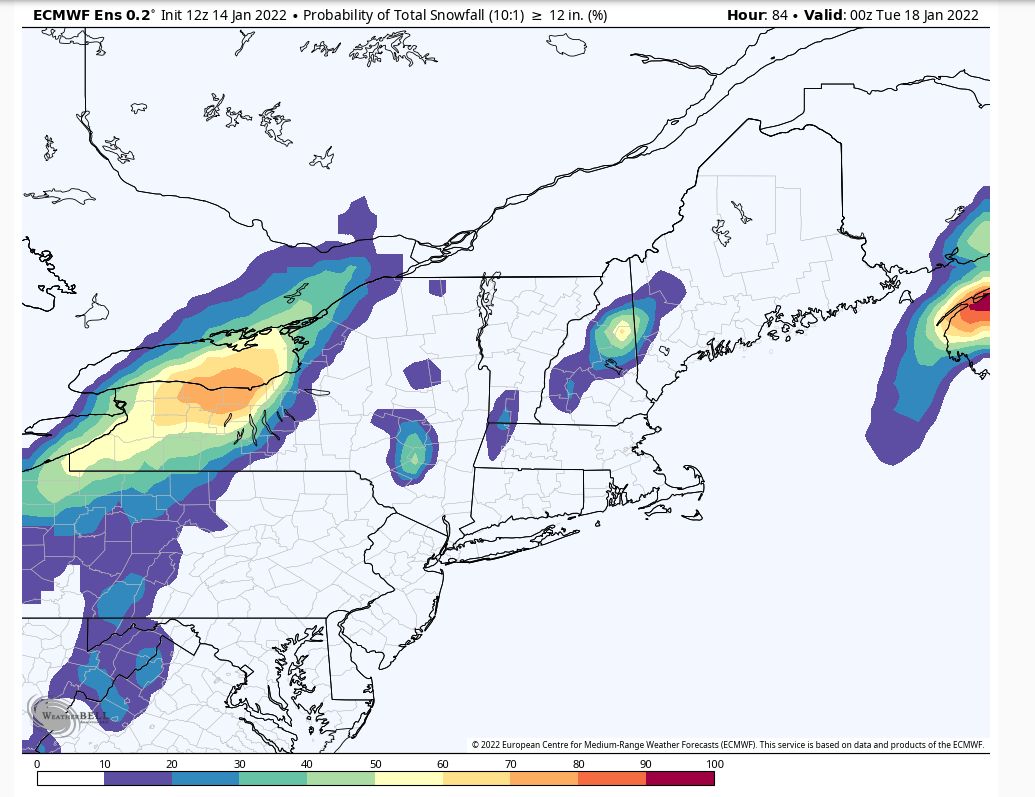
12z Euro ensembles couldn't be much more ideal for my area. 60% probability of 12"+ right imby. I think we have quite the thump coming up this way.

-
My girlfriend and I have decided to check out the Wilderness area this coming Sunday. It's a bit of a long trek from Jackson, especially for one day...but we're itching to get into the woods for some off piste skiing, and that won't be happening in NH until after Monday's event (hopefully). It sounds like the Wilderness area is already skiing well, so we're going for it. I'm really looking forward to it!
-
This morning's gfs is quite robust for my area. I think my location will have the perfect juxtaposition of sub-freezing temperatures and upslope flow. Down on the valley floor, low level temps could get a bit marginal for efficient snowfall accumulations by mid to late Monday afternoon (though most of the QPF could be done by then anyway)...but here at 1500' I don't see much chance of going above freezing, and these east/southeast LLJ scenarios often result in a QPF maximum somewhere between my location and Pinkham Notch. Thinking Black Mountain could end up being the snowfall jackpot for this one, at least locally. And I would argue there isn't any mountain in New England that needs it more. It's obviously way too early to get super specific with localized minima/maxima but I have noticed Wildcat can sometimes get less if there is even the slightest southerly component to the LLJ. It happened during the 1/16 event last year when I managed 8" in my location, then noticed an immediate reduction in snowfall amounts as soon as I drove past Pinkham Notch and lost just the slightest bit of elevation on the other side. It'll be interesting to see how the models resolve the low level wind trajectories as we get closer to the event.
-
Quite a winter weekend shaping up between the arctic blast late tomorrow into Saturday, and the winter storm on Monday. Projected wind chills by Saturday morning are downright scary. I got out for some morning laps in the sub-zero temps this week, but I think these wind chills will be enough to keep me indoors Saturday morning lol.
-
Cold air hung tough in my location today. Our daytime high was only 18F after a low of -8F this morning, then it briefly slipped back down to 16F around sunset before rising back to the current daily high of 21F. Big difference between here and southern parts of the state today. Starting to feel the increasingly possibility of an eastern slope special with the upcoming MLK event. Still a few days to shift one way or another, but the models have a pretty robust easterly LLJ which often cranks out very efficient precip rates in this location. We'll see.
-
Managed to get up to +9F today but we have since tanked back down to -5F. Tough call in terms of how cold it'll get in my location tonight; we're radiating like hell right now, but as warm advection begins aloft my elevation could eventually level off and possibly even rise. Should be a pretty decent inversion by morning.
-
Made it down to -8F at my location this morning, which is the coldest I have observed in the last two winters. Last year's low temp was -3F on 1/30. Up to 3F now at noon. Cold as it was this morning, it actually was a very pleasant morning for a skin up Black Mountain NH! When I arrived in the parking lot at 7:30 it was -3F but there was virtually no wind, which was somewhat surprising. Due to Black's south-facing exposure, the sun hits the mountain early so I skinned up primarily in the sunshine. I don't think the mountain has been open these last two days, so after Sunday's freezing rain event the snow conditions were...chattery...but I always enjoy a good adventure ski every now and then lol.
-
It's been flurrying here, but no accumulation since the synoptic stuff shut off around noon. I think I've been between streamers for the most part. But nice to see flakes floating around out there regardless.
-
This is incredible insight, thank you!! I think we have made other plans for this immediate weekend, but it's likely we'll be taking the trip out there NEXT weekend. I haven't skied Bolton in years, and I've never done any uphill there. Looking forward to experiencing the mountain in a different way!
-
I've been wanting to check out the Wilderness Trail at Bolton, but I have a girlfriend who is a lot more nervous about skiing a thin base since she is still new to the off piste stuff. Wondering if we should give this a go this weekend, or wait for one more storm cycle. I've been itching to get off groomers and at this point I'm willing to drive a few hours if I have to!
-
Snow just ended here. Total accumulation 1.3 inches.
-
Calling it 1.1" here as of 10am in Jackson. I did a couple laps at Cranmore earlier this morning, and it seemed like there was just a tad more there. Either way...we're not cashing in like SNE, but I'll take the refresher. 22/19 with light snow continuing.
-
And I'm more of a backcountry skier than I am a resort skier. GBA glades, the Sherburne and Gulf of Slides ski trails on Mount Washington, the Tucker Brook ski trail on the backside of Cannon, the Doublehead ski trail right in my backyard, etc. Obviously none of that is happening right now. In time, hopefully.
-
Made it up to 37F here today, but the snow is so glaciated at this point I don't really think we lost much over this way. I have a very crusty 5" base out there right now. Depth wise, we're roughly on par with last year at this time, then we had an 8" event on 1/16 that brought the depth to more than a foot. These are some lean times in the White Mountains for sure. Luckily the winter is long, and I'm eternally optimistic that things can turn around. February, March, and even April can be really good around here....so here's to hoping for a back-ended winter.
-
Drove over to Sunday River this afternoon to do a couple uphill laps. It rained most of the way there, except for a short stretch between Pinkham Notch and Gorham. Once I got to Shelburne NH it flipped back to rain and remained rain until the road up to the Jordan Hotel, where it flipped back to a 34-degree snow. Sunday River ended up with a very slight coating, and there was also a very slight coating (less than 1") between Gorham and Pinkham Notch on the drive home. No snow here in Jackson. Now we await the arctic air.
-
37/37 with a "heavy drizzle" at the moment. What a nasty weekend overall. Having said that, I echo J. Spin's sentiment regarding a very good holiday week for outdoor activities. I managed to get over to Stowe for the first time on Wednesday and Thursday...and while lift-serviced terrain is somewhat limited, it was more than enough to satisfy my girlfriend (second year on skis) who was quite content lapping the Meadows chair...as well as her 9 year old son who was beyond thrilled to ski his first black diamond (Nosedive). I can't wait to go back when more terrain is open. Back on the weather side....it was one year ago today when we established our seasonal snowpack for the 2020-2021 winter. This year we managed to do it a little earlier (12/18) but we're still waiting for the first 6" snowfall in these parts whereas last year there had already been three at this point. We've had enough nickel and dime events that I think one more dense snowfall of 6-8" would be enough to open up some limited backcountry terrain. Really hoping the Friday event pans out.
-
This morning’s 1” snowfall brought my depth up to 7-8” OTG. Not super impressive for the White Mountains in late December, but a heck of a lot better than last year at this time (bare ground). I’m definitely concerned about the upcoming weekend, so hoping for positive trends in the next few days.
-
Watching Wednesday's system very closely. Models do seem to be trending closer with time, and suddenly we have a legitimate event on the gfs.
-
I hiked Mount Clay from the west side today, and it was still snowing steadily even when I left the Ammonoosuc Ravine trailhead at 4pm. Amazing how the post-synoptic upslope can persist for so long in your area. Having said that, I was pretty surprised at how little new snow there was when I arrived at 9am this morning. Your area was definitely a localized snowfall minimum during the synoptic portion of this event.
-
5.0" here. OVC and 25F with a few flakes still floating down out there. Beautiful morning.
-
4.0" with steady snow continuing in Jackson NH. 23 degrees.
-
4.0" here
-
OVC and 30/20 in Jackson NH. Awaiting the first flakes here.
-
Really liking where I sit with tomorrow's event. Just reviewed the 6" snowfall probabilities on the Euro, GFS, and Canadian ensembles and all seem to be honing in on a central VT/NH jackpot. In NH I like the Lakes Region up to the southern White Mountains (along and south of Franconia, Crawford, and Pinkham Notches) for the best chance of 6" or more. Northern Whites should be good for 3-6 inches. After settling down to 41F this morning, we've bounced back to 45F at midday. No hint of snow anywhere. Looking forward to hopefully turning the corner this weekend.
-
Spiked from 36F at sunset last night to 56F at some point during the night. It was still 49F when I woke up at 5:00 but we've steadily dropped down to 41F now. My anemometer has registered a peak gust of 30 so far, but winds are likely stronger than that since my yard is quite wooded. No power interruptions yet.