StormfanaticInd
-
Posts
2,065 -
Joined
-
Last visited
Content Type
Profiles
Blogs
Forums
American Weather
Media Demo
Store
Gallery
Everything posted by StormfanaticInd
-
Fascinating.....
-
Jan 24-26th Potential Something Part 2
StormfanaticInd replied to Chicago Storm's topic in Lakes/Ohio Valley
That sucks -
Jan 24-26th Potential Something Part 2
StormfanaticInd replied to Chicago Storm's topic in Lakes/Ohio Valley
Really big flakes to -
Jan 24-26th Potential Something Part 2
StormfanaticInd replied to Chicago Storm's topic in Lakes/Ohio Valley
Heavy snow now!!! -
Jan 24-26th Potential Something Part 2
StormfanaticInd replied to Chicago Storm's topic in Lakes/Ohio Valley
Moderate mix right now -
Vaccines are already having a big impact
-
We are seeing amazing drops in hospitalizations. Down to 110k. Again very good news
-
Jan 24-26th Potential Something Part 2
StormfanaticInd replied to Chicago Storm's topic in Lakes/Ohio Valley
Now we wait -
Jan 24-26th Potential Something Part 2
StormfanaticInd replied to Chicago Storm's topic in Lakes/Ohio Valley
Gfs is different -
Jan 24-26th Potential Something Part 2
StormfanaticInd replied to Chicago Storm's topic in Lakes/Ohio Valley
Not possible -
Jan 24-26th Potential Something Part 2
StormfanaticInd replied to Chicago Storm's topic in Lakes/Ohio Valley
.25in is icestorm criteria -
Jan 24-26th Potential Something Part 2
StormfanaticInd replied to Chicago Storm's topic in Lakes/Ohio Valley
Its fighting a 1045 high to the north -
Jan 24-26th Potential Something Part 2
StormfanaticInd replied to Chicago Storm's topic in Lakes/Ohio Valley
Special Weather Statement National Weather Service Indianapolis IN 1221 PM EST Sun Jan 24 2021 INZ021-028>031-035>049-051>057-060>065-067>072-250300- Carroll-Warren-Tippecanoe-Clinton-Howard-Fountain-Montgomery- Boone-Tipton-Hamilton-Madison-Delaware-Randolph-Vermillion-Parke- Putnam-Hendricks-Marion-Hancock-Henry-Vigo-Clay-Owen-Morgan- Johnson-Shelby-Rush-Sullivan-Greene-Monroe-Brown-Bartholomew- Decatur-Knox-Daviess-Martin-Lawrence-Jackson-Jennings- Including the cities of Delphi, Flora, Williamsport, West Lebanon, Lafayette, West Lafayette, Frankfort, Kokomo, Attica, Covington, Veedersburg, Crawfordsville, Lebanon, Zionsville, Tipton, Fishers, Carmel, Noblesville, Anderson, Muncie, Winchester, Clinton, Newport, Rockville, Greencastle, Plainfield, Brownsburg, Danville, Indianapolis, Greenfield, Cumberland, New Castle, Terre Haute, Brazil, Clay City, Spencer, Martinsville, Mooresville, Greenwood, Franklin, Shelbyville, Rushville, Sullivan, Linton, Bloomfield, Bloomington, Nashville, Columbus, Greensburg, Vincennes, Washington, Loogootee, Shoals, Bedford, Mitchell, Seymour, Brownstown, and North Vernon 1221 PM EST Sun Jan 24 2021 ...Freezing Rain expected Monday... Freezing rain, possibly mixed with sleet or snow will move in to areas near and north of a Terre Haute to Greensburg line after 4 AM Monday morning and spread northeast during the day. The precipitation is expected to effect the Metro area before and during morning rush hour. By Monday afternoon, the precipitation will turn to rain over areas near and south of Noblesville and Crawfordsville. Ice accumulation will result slick untreated surfaces Monday. Use caution if traveling and allow plenty of extra time and stopping distance Monday morning. Stay tuned to NOAA Weather Radio and local media for updates. -
Jan 24-26th Potential Something Part 2
StormfanaticInd replied to Chicago Storm's topic in Lakes/Ohio Valley
Respect the block. The bleeding will most likely continue -
Jan 24-26th Potential Something Part 2
StormfanaticInd replied to Chicago Storm's topic in Lakes/Ohio Valley
Nam coming in with icestorm criteria Central Indiana -
Jan 24-26th Potential Something Part 2
StormfanaticInd replied to Chicago Storm's topic in Lakes/Ohio Valley
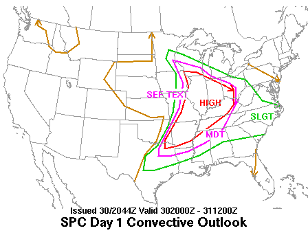
-
Jan 24-26th Potential Something Part 2
StormfanaticInd replied to Chicago Storm's topic in Lakes/Ohio Valley
Probably should issue WWA for central Indiana given what I am seeing -
Jan 24-26th Potential Something Part 2
StormfanaticInd replied to Chicago Storm's topic in Lakes/Ohio Valley
Still a very respectable storm -
Jan 24-26th Potential Something Part 2
StormfanaticInd replied to Chicago Storm's topic in Lakes/Ohio Valley
I'm going with 2-4in in central Indiana. -
Winter 2020-21 Medium/Long Range Discussion
StormfanaticInd replied to Hoosier's topic in Lakes/Ohio Valley
The models are really struggling with this -nao pattern -
Jan 24-26th Potential Something Part 2
StormfanaticInd replied to Chicago Storm's topic in Lakes/Ohio Valley
Hmmm... -
Jan 24-26th Potential Something Part 2
StormfanaticInd replied to Chicago Storm's topic in Lakes/Ohio Valley
-
Jan 24-26th Potential Something Part 2
StormfanaticInd replied to Chicago Storm's topic in Lakes/Ohio Valley
Respect the block -
Jan 24-26th Potential Something Part 2
StormfanaticInd replied to Chicago Storm's topic in Lakes/Ohio Valley
-
Down to 114k hospitalizations. Very encouraging trends continue


