jlh
-
Posts
144 -
Joined
-
Last visited
Content Type
Profiles
Blogs
Forums
American Weather
Media Demo
Store
Gallery
Everything posted by jlh
-
Potential 1/28-1/30 2022 winter storm
jlh replied to Prismshine Productions's topic in Southeastern States
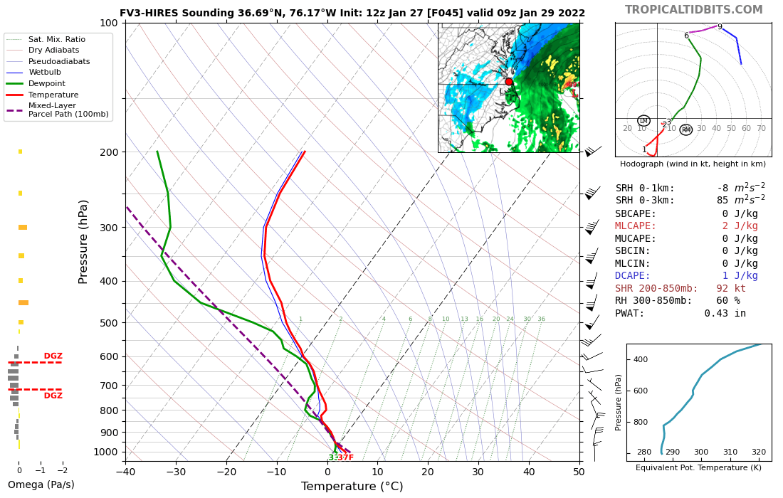
Hampton Roads early Saturday morning.
-
Potential 1/28-1/30 2022 winter storm
jlh replied to Prismshine Productions's topic in Southeastern States
Yeah, I have less and less been a fan of it of late. But the information passed the other day about it not receiving any more development since 2017 explains it. -
Potential 1/28-1/30 2022 winter storm
jlh replied to Prismshine Productions's topic in Southeastern States
Yup. Seems surface temperatures are going to have a hard time getting down the freezing until near sunrise Saturday morning (back side)so while we might get a lot of snow in the sky, unless its convective/heavy it isn't going to last long on the ground. Makes a lot of sense though, often the story with nor'easters in our area. -
Potential 1/28-1/30 2022 winter storm
jlh replied to Prismshine Productions's topic in Southeastern States
Seems as though AKQ is going with the idea of less accumulation even in coastal NE NC. Afternoon update has most of the snow falling just above freezing except for a few hour span. Cut back from 3-6" to less than 2". Hopefully we can snag a bigger window at freezing than they are thinking but that onshore NE flow, makes a lot of sense why the temps were bumped up. -
Definitely been a good sniffer at range.
-
Weather Station Recommendations
jlh replied to Northern FireWX Watcher's topic in Weather Marketplace
Posting this to whoever drops in later on... I have had awesome results with my Acurite Atlas 7 in 1. -
There used to be one made by a company called BIOS that would do that, do not know if they are still around though. Nearly everything these days that has a screen and shows local forecasts still utilizes at least a temperature sensor in your backyard.
-
Yeah, a low is going to be out there, that is about all i'm on board with. Guidance has shifted from perhaps 1" to over 12+" in my backyard the last few days. Just waiting for tomorrow evening to get here so I can gaze at a radar and out of my window.
-
Potential 1/28-1/30 2022 winter storm
jlh replied to Prismshine Productions's topic in Southeastern States
RGEM depicts FGEN banding in that same area. -
Potential 1/28-1/30 2022 winter storm
jlh replied to Prismshine Productions's topic in Southeastern States
Really now? I figured they were different because tropical tidbits had them listed separately lol. Thanks for letting me know! I see RDPS is listed as the GEM's pilot model. Makes sense now. -
Potential 1/28-1/30 2022 winter storm
jlh replied to Prismshine Productions's topic in Southeastern States
Very similar to the RGEM, perhaps ever so slightly further west. -
That's really awesome, super happy about that.
-
Must have been this week, it wasn't there for the last storm.
-
Potential 1/28-1/30 2022 winter storm
jlh replied to Prismshine Productions's topic in Southeastern States
AKQ issued Watch for the coastal plain, calling for 3-6". Forecast discussion noted they were going with the Euro as the middle ground between the GFS and NAM. -
Potential 1/28-1/30 2022 winter storm
jlh replied to Prismshine Productions's topic in Southeastern States
Such a nice thought, have a feeling Mr. GFS is going to have something to say about all of that. I can't recall when the most recent 12+ inch dump happened in NE NC but from what I've seen here I suppose it was the 80s. -
NAM is playing with my emotions
-
Potential 1/28-1/30 2022 winter storm
jlh replied to Prismshine Productions's topic in Southeastern States
Was that the same as the Circus Blizzard or was that later in the 80s? -
Potential 1/28-1/30 2022 winter storm
jlh replied to Prismshine Productions's topic in Southeastern States
Holy moly -
The lack of moisture and the strength of the low with the location of the pressure center. However I noticed on the same run, a few charts down in time it repositions the pressure center with a reading more what I am used to seeing out there with these, and the moisture is there.
-
Not buying that one bit.
-
Potential 1/28-1/30 2022 winter storm
jlh replied to Prismshine Productions's topic in Southeastern States
Something is something. Will be most interesting to see if a few of these shift back just a tad tomorrow. Seems to be the way it goes. -
Potential 1/28-1/30 2022 winter storm
jlh replied to Prismshine Productions's topic in Southeastern States
Question for the long term forecasters... Something that is interesting to me is looking at the 18Z GFS at 84. For us coastal NC/NE NC folks, a low center that relatively close to Hatteras usually features a pretty noticeable warm nose that typically keeps us cold rain with the moisture gone before the column sufficiently cools , However, despite somewhat onshore winds at the same time the warm nose in the forecast sounding for the same plot shows only a tiny bump of a warm nose (and still below 0C). My training in weather is more operational than theory and I know the resolution on the GFS is a bit tough along the coast with the influence of the water, however it is unusual that it would depict snow all the way to the bay with where it is depicting this. In the past this onshore influence would normally be depicted and make sense. What would explain the difference this time? I wouldn't think that ocean temperatures would be significantly colder than average, would it? or is the GFS possibly way out to lunch with the lack ocean influence before winds shift more to the NW from NE? -
Potential 1/28-1/30 2022 winter storm
jlh replied to Prismshine Productions's topic in Southeastern States
Definitely starting to look that way -
Potential 1/28-1/30 2022 winter storm
jlh replied to Prismshine Productions's topic in Southeastern States
I'm almost rubbing my eyes in disbelief that we would get two systems delivering snow 7 days apart in this area. -
Took one from Norfolk to DC not too long ago and was pleasantly surprised with the internet, much better than it used to be.