vortex95
-
Posts
347 -
Joined
-
Last visited
Content Type
Profiles
Blogs
Forums
American Weather
Media Demo
Store
Gallery
Everything posted by vortex95
-
Ignore the fact we just had a great late season snowfall in SNE. Oh, but NIMBY, so who cares? https://www.youtube.com/watch?v=w_6bAt_HwnI
-
I'm sure CoastalWx will agree wholeheartedly!
-
Blue snow is a result of the high liquid water content. You typically only see that when you dig into the snow and there is more then a foot on the ground.
-
Sounds like a good job for CoastalWx! Odd that the HRRR just picked that one area repeatedly. Why didn't it do it for other mtn peaks that were even higher then Brace Mtn in the area? The 3 km NAM does this systematically all the time for all higher peaks, but HRRR singnaling out one mtn for multiple runs? Not sure I have seen that before.
-
Crazy mountain QPF/snow bulls-eyes are a big 3 km NAM issue, but not nearly as much for the HRRR.
-
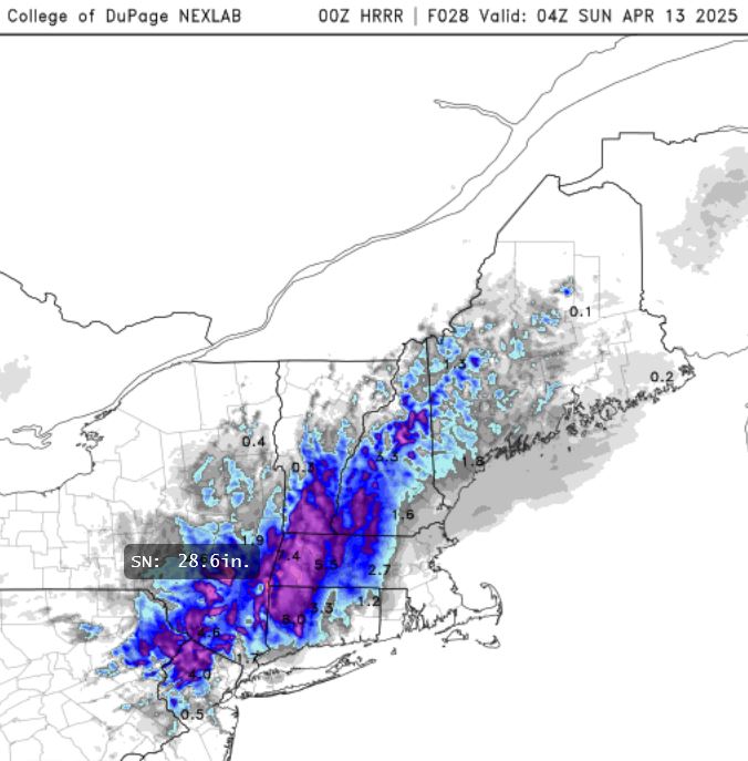
23z HRRR was not a fluke. 00z HRRR even more aggressive. Looks like it is focused on Brace Mountain NY (elevation 2311 ft). It has a 3" QPF bulls-eye there, and wicked downslope screw zone for pcpn just to its W. Kuchera says 28.6". Why not? Low track and flow is right for great upslope flow this area. Of course, we may never get verification unless a true weenie goes up there to measure, but either way, some pretty amazing totals for April seems likely this area. EDIT: Going back several runs of the HRRR, and it is consistent w/ the Brace Mtn bulls-eye.
-
Not if the band is in the right place and pivots.
-
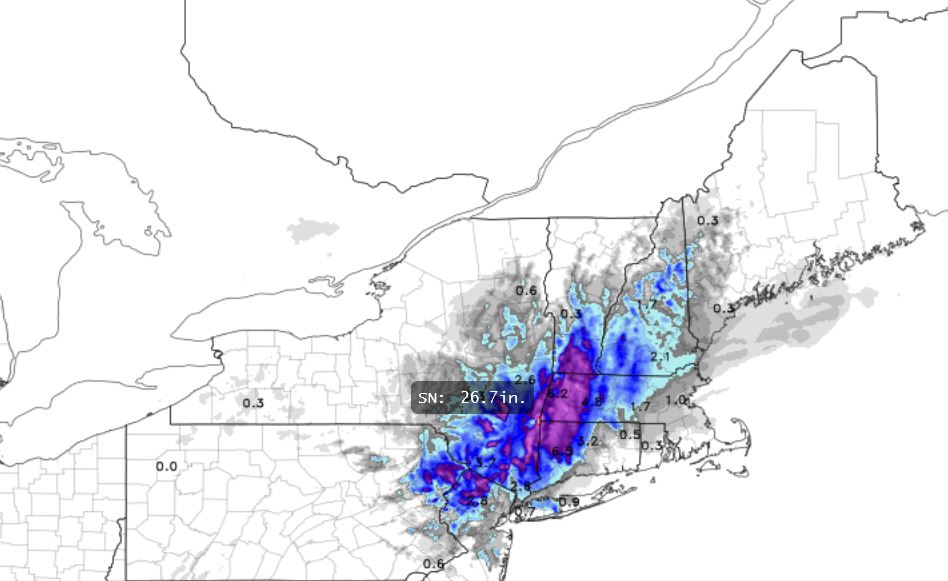
23z HRRR Kuchera shows almost 27" right at the intersection of the MA/CT/NY border. CoastalWx has to be impressed! Berkshires/Catskills special? Slide Mountain could do *really* well!
-
The title of this thread is "Please end it." Well, CoastalWx will still have to wait b/c no sign winter wants to end anything time. If the ECMWF a week from now is any sign, well perhaps a "late season surprise" may still happen!

-
I recall NWS PWM continued the winter storm warning well after the event was done and when there full sun b/c the melting was causing a huge hazard due to ice falling off everything.
-
I saw a mention in a NWS chat group that the BOS -SN reported was most likely PL, but I can't confirm if that was indeed the case.
-
When you reference all the back to the start of period of record for location, that's a climate statement by default, or will be inferred as such by many. I pointed out the caveats of the data and details on a meteorological level (how snow and sleet are counted as one - frozen precip). Not everyone is aware of this. Details count in science. Also, stating "for the first time on record" is subject to debate here. One should not talk in absolutes when there is this kind of uncertainly. That's a big problem in science-based data these days, the level of uncertainty is often ignored w/ measurements and data. No one is discounting this is a low snow period for SNE, as I said that in my post, but the historical context perspective was of value. Facts are meaningless w/o context.
-
This is assuming a lot. First, splitting hairs between frozen precip (snow vs. sleet) when it is only a trace is inconsequential as to wx/climate. So BOS has a trace of sleet instead of snow in a month - makes zero difference in long-term climate normals or in sensible wx. Second, March 1894, 1901, 1915. 1921, and 1925 all had a trace of frozen precip. Do we really know if all those months had snow? Like 2025, it could have been just sleet. And from a climate standpoint, why is it that a trace of frozen precip occurred 5 times in March 1894-1925, and then did not occur again until 1979 despite overall warming? And then it took another 30+ years for to have another March trace again? The point is what has happened in recent years for the dearth of snow in March in BOS is nothing new and not unprecedented when avoiding short periods slicing/dicing things down to do everything possible to find a record and mention the word 'unprecedented' for content and something to hype. Just b/c recently snow has dipped big time is meaningless in the context of climate and trends. Much too short term for determining anything either way. The "recency bias" logical fallacy is tiresome, yet it is pushed on us repeatedly b/c people fall for it over and over. We live way too much in the here and now and forget even the recent past, which skews our perception of things big time. So I say stop making things bigger or more impressive than they really are, esp. when you are talking about long-term wx/climate, records, and the overall pix. Sure, it 'CoastalWx blows' that snow has been hard to come by in recent years in SNE, but CoastalWx knows the pain all too well from the 1980s how crappy it was then! Decadal cycles occur! He needs to remember that 1991-2020 was the *snowiest* 30-yr period on record for BOS, w/ the seasonal avg going *up* 6" from the 1981-2010 normals. Now that is impressive for a 30-yr normal change for snowfall for a location that is right on the ocean and deals w/ ptype issue a lot!
-
K3J1 - Ridgeland SC KXNI - Zuni NM KU16 - Eagle Range UT 41.067 -113.083 1292m KU19 - Granite Peak UT 40.167 -113.350 1310m KU96 - Halls Crossing UT
-
KMWS - Mount Wilson CA 34.231/-118.069 1702m KNEN - Jacksonville/Whitehouse NOLF FL KNRA - Coupeville NOLF WA KO26 - Lone Pine CA KPHG - Phillipsburg KS KU14 - Nephi UT KVMR - Vermillion SD
- 1 reply
-
- 3
-

-
K4M3 - Carlisle AR K4V9 - Neligh NE K8D4 - Sparta MI K9A4 - Courtland AL KN24 - Questa NM KTAH - Green Canyon 641 LA - 27.37 / -90.71 65m KU10 - Preston ID KX21 - Titusville/Dunn FL POKA - Tununak AK
-
K1B9 - Mansfield MA K5A9 - Warm Springs GA K6E5 - Desmet SD KBXM - Brunswick ME KSUO - Rosebud SD PFCB - Chenega AK
- 1 reply
-
- 3
-
-

-
K3K7 - Leoti KS K3W7 - Electric City WA KE01 - Monahans TX KF95 - Blountstown FL KI40 - Coshocton OH PFKO - Kotlik AK PFZK - Akiachak AK
- 1 reply
-
- 2
-
-
K49B- Sturgis SD K9Y1 - Killdeer ND KETO - Mississippi Canyon 941 LA 28.03N / 89.10W 43m KTQS - Lompoc/South Vandenberg CA 34:38N / 120:37W 34m KVGN - KVGN - Lompoc/North Vandenberg CA 34:51N 120:36W 93m
-
Concerning the "extended" storm snowfalls total in NNE, I was looking at the hydrological reports from GYX through 12z Sunday. Gray Knob in NH (elevation 4375') reported 45.7" for the storm ending around 12z Sunday! This is the cabin there presumably that is run by the Randolph Mtn Club? Day/LEQ/SF: Thu 2.05" 9.0" Fri 2.68" 28.3" Sat .53" 4.9" Sun .40" 3.5" This matches well with the HRRR/3 km NAM 10:1 snowfall total forecast for this area (40-55"). Is CoastalWx impressed?! Nice to have verification of these very high totals that the meso models often show. Now only if we could get something near the summit of Mt Katahdin! Also 63" OTG Sunday AM Gray Knob. Highest late season snow OTG for New England I have seen is 135" at Mt Mansfield the 3rd week of April 1996. 27" fell in three days from a cold upper low to raise the snowcover to this point. If you want to view the hydrological reports from GYX, go here: https://mesonet.agron.iastate.edu/wx/afos/old.phtml and enter "HYDGYX." There are other hut/cabin reports that show up in this bulletin, but Gray Knob was the only one that reported consistently throughout this past storm. You can go back up to 1500 versions of any NWS text product, which mean for the lesser issued bulletins, you can go 10+ years back in some cases. Even the text products under the former WSFO/WSO codes, like BOS/PWM/ORH/PVD/CON/BDL/BDR/ALB/NYC, are here, and go back as far as 1983. A lot missing though for these codes, but there is some cool stuff to be found!
-
Noted a report on this thread 3-4" of sleet in MA. What location(s)? I ask b/c it is not common for anywhere in New England to get 3" or more of sleet in storm, just based on empirical observations. You see it more often it seems in Dixie/South or continental climate. Two storms ago with the blockbuster snow amounts in NNE, 3" of sleet was report at a couple locations in ME.
-
BOS the day after the snowstorm with full sun only had a max of 25 F. That was *lower* than the previous record low *min* for the day! -20 to -25 C at 850 behind the storm. Probably one of the coldest 850 on record NEUS. I do recall very strong but quick cold shot in early April 1995 (no real storm, just a strong FROPA). 1000-500 thickness dropped below 500 dm for a short time in NNE!
-
Wow. What is your snowfall average for the winter? Elevation?
-
The Congrats Dendrite Deck Destroyer 3/23-3/25 obs discussion
vortex95 replied to Ginx snewx's topic in New England
CoastalWx wrote: The only storms that impressed me was the one before Christmas and this one. This one wasn’t a classic nor Easter though. 60kts from the south at 850 will deliver the warmth aloft for sure. It was juiced for sure. --------------------------------------- No, not a classic Nor'easter, rather stringy pressure pattern NNE to SSW. I recall a rule thumb decades ago that said, "N-S orientated 850 lows do not usually produce large areas of +SN." Well, that did not work out here! My point is that winter storms come in a spectrum, and thinking "classic Nor'easter" all the time, you are going to be disappointed. What matters is what the storm prodcues, no? Don't look for the 970 mb KU monster with the perfect WCB and CCB all the time! Take Dec 23, 1997. Nothing special for a pattern or sfc low. 4-8" max forecast, and it ends up 12-24" in SNE! Mega weenie CSI bands or DGZ zones don't need a crazy comma head with a 510 dm 500 mb low moving in! Or how about CoastalWx's all-time "surprise" fav -- March 6-7, 2013? Let's have the sfc low go out 600 mi SE of ACK, and Blue Hill gets a top 5 snowstorm of 30!" Or that one storm in the mega blitz Jan-Feb 2015. We got a burst of snow in SNE in the evening with this mesoscale thingy clearly showing up on radar as a curl. It moves N to srn NH, and stalls. Then the sky becomes partly cloudy over parts of sern MA for a time not long after midnight, then the mesoscale thingy drops back S, the 500 support moves in, and its snow weenie heaven just before sunrise with ++TSSN over ern MA. That was nuts! One of the oddest big snowstorms I have seen. But in the end, still buried! See a theme here?, non-standard, outside the classic box snow events get the job done and can be among the best ev-AH, esp. b/c of the surprise factor! So this most recent storm falls outside the box. Yes, it did not get SNE with big snows, but it was very close. And we are talking late March here. If it was a month earlier?