Ed, snow and hurricane fan
-
Posts
2,133 -
Joined
-
Last visited
Content Type
Profiles
Blogs
Forums
American Weather
Media Demo
Store
Gallery
Everything posted by Ed, snow and hurricane fan
-

2024 Atlantic Hurricane Season
Ed, snow and hurricane fan replied to Stormchaserchuck1's topic in Tropical Headquarters
94L to 50% and area E of Beryl now a 7 day cherry. 2. Eastern Tropical Atlantic: An area of low pressure located several hundred miles southwest of the Cabo Verde Islands is producing an area of disorganized showers and thunderstorms. Environmental conditions appear conducive for additional development of this system, and a tropical depression could form by the middle of next week while it moves generally westward at 15 to 20 mph across the eastern and central tropical Atlantic. * Formation chance through 48 hours...low...30 percent. * Formation chance through 7 days...high...70 percent. -
SHIPS/DSHIPS from secret 6-8 day NHC track implies a landfall and then back into the Gulf or BoC. 132 144 156 168 V (KT) NO LAND 60 68 75 81 87 95 96 94 87 82 77 74 71 72 75 76 77 V (KT) LAND 60 68 75 81 87 95 96 94 87 82 77 74 71 72 58 37 42
-
Tomer Burg on Twitter says not to discount the hi-res hurricane models, or N of the globals and ensembles, Especially since Beryl is a small system and apparently intensifying briskly. GEFS seem close to a best case scenario, Beryl runs into a wall of shear, which then results in a bend back W and into C. America as a weakening system.
.thumb.png.f4211b9bdb33e59bb20c0e261d140bdd.png)
-
NHC website has 2 syllables. Beryl BEHR-ril https://www.nhc.noaa.gov/pdf/aboutnames_pronounce_atlc.pdf
-
AL, 02, 2024062900, , BEST, 0, 92N, 427W, 35, 1006, TS, 34, NEQ, 40, 0, 0, 40, 1011, 150, 40, 45, 0, L, 0, , 0, 0, BERYL, M, 0, , 0, 0, 0, 0, genesis-num, 008,
-
2024 Atlantic Hurricane Season
Ed, snow and hurricane fan replied to Stormchaserchuck1's topic in Tropical Headquarters
2 oranges and a TD well on its way to Beryl. And it is June. -
70 WTNT42 KNHC 282033 TCDAT2 Tropical Depression Two Discussion Number 1 NWS National Hurricane Center Miami FL AL022024 500 PM AST Fri Jun 28 2024 The low pressure system that NHC has been monitoring over the central tropical Atlantic has developed sufficiently organized deep convection in bands around the center. In addition, visible satellite images show that the circulation has tightened, and the center now appears well-defined. Thus, a tropical depression has formed, and the initial intensity is set at 30 kt based on the latest Dvorak classifications. Development this far east in late June is unusual, in fact, there have only been a few storms in history that have formed over the central or eastern tropical Atlantic this early in the year. The depression is moving westward at 15 kt. A strong subtropical ridge to the north of the system should keep it moving relatively quickly westward to west-northwestward during the next few days. The system might gain a little more latitude toward the end of the forecast period when it nears a weakness in the subtropical ridge. There is a fair amount of spread in the model guidance, especially in the day 3-5 time frame, due to differences in the strength of the ridge and the aforementioned weakness. The NHC track forecast lies near the consensus aids and is slightly south of the middle of the guidance envelope. Based on this forecast, the system is expected to move across the Windward Islands Sunday night and Monday and track across the eastern and central Caribbean Sea through the middle of next week. Typically, the atmospheric environment is unfavorable for intensification in this portion of the Atlantic basin in late June. However, the overall atmospheric and oceanic conditions appear conducive for steady strengthening during the next few days. Accordingly, the official forecast calls for strengthening and shows the depression becoming a tropical storm tonight or early Saturday and then a hurricane before it reaches the Windward Islands. It should be noted that some of the model guidance is quite aggressive and a fair amount are higher than the official forecast. For example, the hurricane regional models show the system becoming a major hurricane and the GFS model shows the system deepening below 970 mb prior to reaching the Windward Islands. Key Messages: 1. Tropical Depression Two is expected to strengthen and be a hurricane when it reaches the Windward Islands late Sunday night or Monday, bringing a risk of heavy rainfall, hurricane-force winds, and dangerous storm surge and waves. 2. Hurricane and Tropical Storm Watches will likely be required for portions of the Windward and southern Leeward Islands later tonight or early Saturday. 3. Interests in the central and western Caribbean should monitor the progress of this system. Users are reminded that there is large uncertainty at days 4 and 5 and to not focus on the specific details of the track or intensity forecast. FORECAST POSITIONS AND MAX WINDS INIT 28/2100Z 9.1N 41.9W 30 KT 35 MPH 12H 29/0600Z 9.4N 44.5W 35 KT 40 MPH 24H 29/1800Z 10.1N 48.0W 40 KT 45 MPH 36H 30/0600Z 10.7N 51.5W 50 KT 60 MPH 48H 30/1800Z 11.3N 54.8W 65 KT 75 MPH 60H 01/0600Z 12.0N 58.2W 75 KT 85 MPH 72H 01/1800Z 13.0N 61.9W 85 KT 100 MPH 96H 02/1800Z 15.5N 69.2W 90 KT 105 MPH 120H 03/1800Z 17.5N 76.4W 80 KT 90 MPH $$ Forecaster Cangialosi
-
Tropical Tidbits has it as TD #2. AL, 02, 2024062818, , BEST, 0, 90N, 410W, 30, 1007, TD, 34, NEQ, 0, 0, 0, 0, 1011, 150, 50, 0, 0, L, 0, , 0, 0, TWO, S, 0, , 0, 0, 0, 0, genesis-num, 008, TRANSITIONED, alA52024 to al022024
-
Andy Hazelton, one of the HRD scientists developing HAFS, says the model is calibrated for existing depressions or storms and can be a bit too enthusiastic on invests.
-
2. Eastern Tropical Atlantic (AL95): Satellite images indicate that a tropical wave located several hundred miles southwest of the Cabo Verde Islands has become better organized since yesterday with a more concentrated area of thunderstorms. Environmental conditions are forecast to be unusually conducive for late June across the central and western tropical Atlantic, and further development of this system is anticipated. A tropical depression or tropical storm could form this weekend several hundred miles east of the Windward Islands while the system moves westward at 15 to 20 mph. * Formation chance through 48 hours...low...30 percent. * Formation chance through 7 days...medium...60 percent.
-
I could be crazy and say Dennis. But I won't.
-
About 970 mb. I don't have a PPV model service which would show max wind.
-
18Z GFS has a pretty MOGified TC into the Windward Islands.
-
2024 Atlantic Hurricane Season
Ed, snow and hurricane fan replied to Stormchaserchuck1's topic in Tropical Headquarters
-
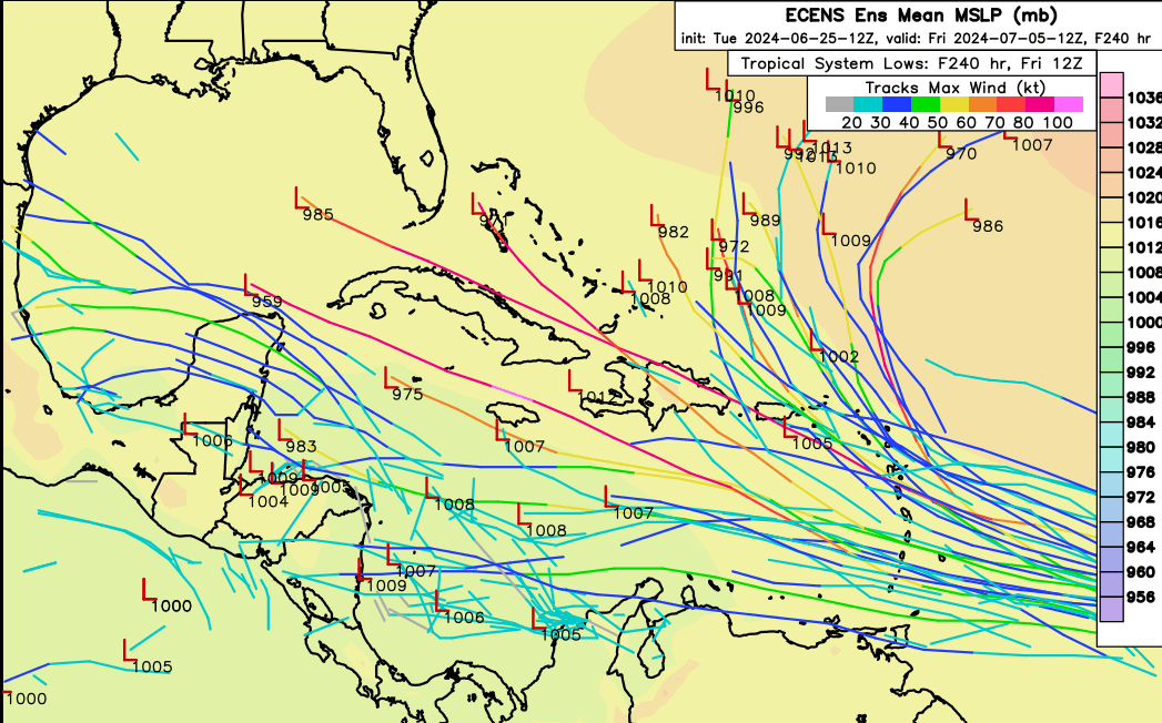
95L has been designated. Possible Caribbean threat next week. Euro and ensembles are aggressive moving it into the Caribbean, GFS and ensembles less so, showing weakening. Post the images and model goodies here.
-
2024 Atlantic Hurricane Season
Ed, snow and hurricane fan replied to Stormchaserchuck1's topic in Tropical Headquarters
I don't trust anything showing an early July system strengthening in the Caribbean https://x.com/NbergWX/status/1806039356387271038 -
2024 Atlantic Hurricane Season
Ed, snow and hurricane fan replied to Stormchaserchuck1's topic in Tropical Headquarters
I tend to think the GFS ensembles are correct in showing members entering the Caribbean weaken and die. The ones missing N of the islands menace ECUSA but stay offshore. Many models/ensembles also picking up on something behind the first E ATL wave, which would be something I don't recall, an active June/July MDR wave train. -
2024 Atlantic Hurricane Season
Ed, snow and hurricane fan replied to Stormchaserchuck1's topic in Tropical Headquarters
I'm not territorial about these things. I was waiting for an invest tag. -
2024 Atlantic Hurricane Season
Ed, snow and hurricane fan replied to Stormchaserchuck1's topic in Tropical Headquarters
I'm not sure about whether the system that has a better chance to get named than the current invest (tracks w/o lows show what the ensembles predict for 94L, pretty meh) gets to Cat 3 or above. July Cat 3s are rare, but not unheard of. I use the word 'major', not 'mogger'. I think Dennis 19 years aqgo was the last US July major, I could be wrong, But I don't think I am. -
2024 Atlantic Hurricane Season
Ed, snow and hurricane fan replied to Stormchaserchuck1's topic in Tropical Headquarters
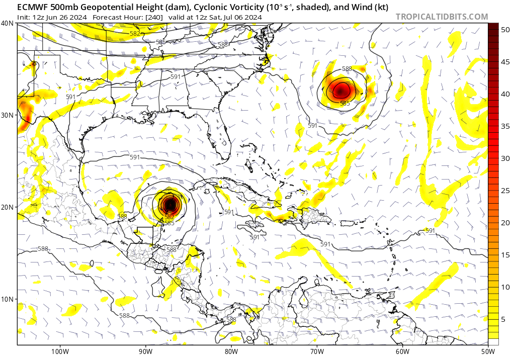
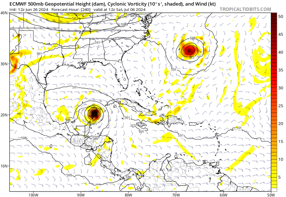
As noted, it isn't season cancel. Looking at the models, the wave coming off Africa could be a 1996 Bertha type system,, a rare July storm for ECUSA. Too early to get excited about something over a week away. It may have changed with the new and more active climatology, but June/July together used to average just over 1 named storm. Follow the lead of GaWx abd WxWatcher, who do not post simply to post. EDIT TO ADD: For newcomers, WeatherNerds (image below), Tropical Tidbits and College of DuPage are good, free websites.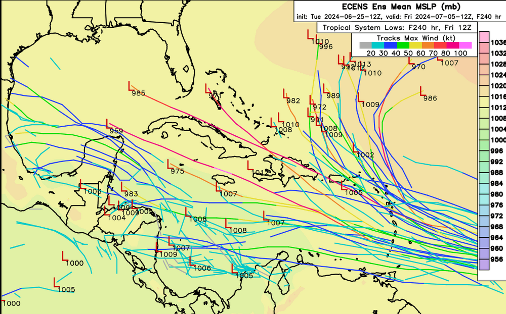
-
2024 Atlantic Hurricane Season
Ed, snow and hurricane fan replied to Stormchaserchuck1's topic in Tropical Headquarters
If a tree falls in the forest... EDIT TO ADD: EURO ensembles similar to the GFS ensembles, with systems entering the Caribbean at 9 or 10 days. -
2024 Atlantic Hurricane Season
Ed, snow and hurricane fan replied to Stormchaserchuck1's topic in Tropical Headquarters
GFS ensembles suggest another 93L, starting deep in the BoC in 2 days. By six days, a few weak Atlantic lows are approaching the Caribbean. Almost all die over in the Caribbean. -
2024 Atlantic Hurricane Season
Ed, snow and hurricane fan replied to Stormchaserchuck1's topic in Tropical Headquarters
I almost started a 93L thread, but I don't think it even gets a number, let alone named. 2 inches immediate coast between CRP and BRO, an relatively small area around La Pesca getting 10 plus inches per GFS. Looks like all the 18Z Euro ensembles get it, I don't see a named storm in the group. A couple of the GEFS might get it. A hint of something w/o any deep convection near 20.5N, 93.5W, CIMMS analyzes decent low and mid level vorticity. Somewhat curved band of convection NNW to E with cold cloud tops. CIMMS analysis shows rather hostile shear from the S but there is divergence and there isn't dry air to the S. GFS and Canadian quickly lower shear, in less than 24 hours, it should be in favorable shear and building an anticyclone, If it had more than about 36 hours over water, it'd probably do something. Ensemble tracks are well clustered and SHIPS gets it to 30 knots. -
Texas 2024 Discussion/Observations
Ed, snow and hurricane fan replied to Stx_Thunder's topic in Central/Western States
If 2 inches happens in the lower RGV that is a good thing, and not a negligible amount. 10% is a normal sea breeze day if we're not under the death ridge. Had a 2 minute long downpour, which came after gusty winds, as the sea breeze passed. It has grown some friends, but isn't an extensive sea breeze. BTW, I am following hints on ensembles for something in the BoC or Caribbean on ensembles. Op Euro suggests a wave gets enhanced coming into the Caribbean, -
Invest 92L in SW Atlantic reached SE US Fri
Ed, snow and hurricane fan replied to GaWx's topic in Tropical Headquarters
People are on it in the 2024 Atlantic Tropics General Thread. I'm holding for a 93L before I start. I don't man AmWx every waking hour, so feel free.

.png.598dad9e8f67c23815c15e7628b89f69.png)