Ed, snow and hurricane fan
-
Posts
2,133 -
Joined
-
Last visited
Content Type
Profiles
Blogs
Forums
American Weather
Media Demo
Store
Gallery
Everything posted by Ed, snow and hurricane fan
-
Eye wobble W on satellite. Probably a trochoidal wobble, or whatever it is called in stronger storms, but enough of those can add up (if it doesn't have as many corresponding N wobbles), and sparing the most people the eyewall is a good thing.
-
Is 'GPM' on the Tropical Tidbits recon page just a reference to meters. Is this plane 3 km up? Altitude: 2989 gpm
-

Major Hurricane Ida
Ed, snow and hurricane fan replied to WxWatcher007's topic in Tropical Headquarters
30 knot plus sustained 10 meter (buildings will get that to street level, I'd think) winds in NOLA by 18Z, 80 knot 850 mb winds just South of MSY itself, or gusts to hurricane force not much over a day away. (6Z HWRF) -
I believe in the day the UN WMO didn't approve a list. The late Dr. John Hope, of TWC, the original 1980s tropical met, contributed the name 'Camille' to the 1969 storm name list because he had a daughter Camille.
-
How many days of fuel do hospital emergency generators have is another question. Pretty sure there are still COVID patients on ventilators. I caught the Rona in December, and have apparently permanent hearing damage, constant tinnitus, and occasional bouts of vertigo. I was sick at home during the cool season for almost 3 weeks, trying to imagine that in early September heat w/o AC. That would have been ugly, and I was never on a vent.
-
It was fuzzy before yesterday, but New Orleans as a danger zone was known by yesterday afternoon, how long does it take to contra-flow I-10 and I-55? The reason they are not ordering mandatory evacuations of New Orleans. Maybe they get lucky and it misses wide right or wide left, or splits the uprights and the levees hold, but even if they don't flood, but I'm seeing 70 knot plus 850 mb winds, which I assume is a safe guesstimate for wind gusts, or, even if the don't flood, anyone whose power isn't from underground cables will have no utilities for a week or more.
-
Major Hurricane Ida
Ed, snow and hurricane fan replied to WxWatcher007's topic in Tropical Headquarters
Eye not well defined last VDM, and I can't see it on satellite, but pretty sure that is temporary. -
Major Hurricane Ida
Ed, snow and hurricane fan replied to WxWatcher007's topic in Tropical Headquarters
Ida won't have 72 hours over the Gulf. New GFS looks a smidge West of worst case for NOLA on track. A smidge. St. Mary parish. Still bad, just not worst case. Looks like ensembles all in Louisiana. I think Western Vermillion parish, assuming a major, affects the least number of people in Louisiana. Op GFS over 15" rain near landfall, less than 3 inches in almost all of Tennessee, although they probably don't need any rain for a few days. -
Major Hurricane Ida
Ed, snow and hurricane fan replied to WxWatcher007's topic in Tropical Headquarters
18Z Euro ensembles, with balloon sonde data from all over the SE USA and aircraft data, now very well clustered, Central Louisiana to Mississippi. Vermillion parish seems like a best case scenario, Abbeville, New Iberia and Morgan City would have surge issues, Lafayette would have wind issues, but a lot less people affected, especially with no mandatory evacs for NOLA, than Lafourche, Terrebonne or Jefferson parish would mean. Brief West trend seems, eyeball, to have been countered by a NNW trend this evening. Waiting on aircraft center fixes to be sure.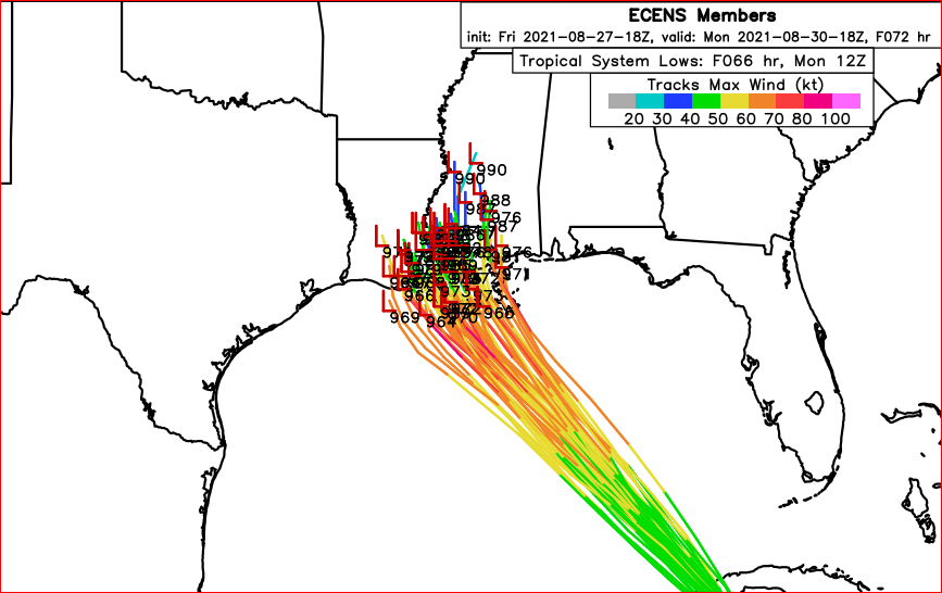
-
Hurricane Ida Forecasting Contest
Ed, snow and hurricane fan replied to WxWatcher007's topic in Tropical Headquarters
New Iberia is on the East side of Vermillion Bay, Ida would almost have to bend back East just before landfall. I used to walk around the cane fields at ARA just North of New Iberia during lunch. -
Hurricane Ida Forecasting Contest
Ed, snow and hurricane fan replied to WxWatcher007's topic in Tropical Headquarters
Maximum Sustained Wind Overall (mph): 145 mphMaximum Sustained Wind at Landfall (mph): 140 mphPressure at Landfall (mb): 937mbLandfall Location: Cocodrie, Terrebonne parish. I spent a week offshore on a barge rig. Came back, flat tire, cracked sidewall from horrible Louisiana roads, horseflies biting like mad putting on the donut, Cocodrie to Lafayette on a Sunday driving on a donut on US 99. (1998) -
Someone I think might be a Juggalo was talking about taking his kids to chase in New Orleans and see a Cat 5. Might be in the other thread Grape Faygo or some such name. That he has bred already is disappointing.
-
I was replying to someone saying Cat 1. It has time to Harvey, I don;t think it gets Cat 5. I could be wrong.
-
I won't have time to go full Cat 5, or even Cat 4 (maybe borderline Cat 3/4, tops) passing over high SSTs/OHC and light shear, Cat 1 seems low. Even w/ less than 2 full days over the Gulf.
-
Banter-ish, but the governor should cancel school in Louisiana, and have every bus driver in the state congregate, maybe somewhere on I-49 North of Lafayette, so whether the track shifts back to Lake Charles or New Orleans, they can be doing mass evacs to Houston. Yes, they'll be big overtime for the drivers. But I remember late month for Katrina meant people on fixed incomes at the end of the month didn't have gas or hotel money to evacuate.
-
Can't argue with climatology.
-
Major Hurricane Ida
Ed, snow and hurricane fan replied to WxWatcher007's topic in Tropical Headquarters
Unless the forecast of the mean ridge by GFS/Euro over Carolinas is really messed up, it might hit the Western Panhandle but the peninsula seems very, very unlikely.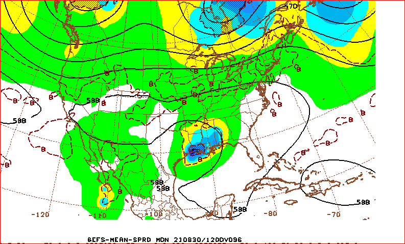
-
Major Hurricane Ida
Ed, snow and hurricane fan replied to WxWatcher007's topic in Tropical Headquarters
45 knot FL winds not too far off Jamaica, an upgrade would seem likely. Ridge position in ensembles, peninsular Florida doesn't look like it could happen, but a shift East to even Pensacola is possible if that MLC is the where the LLC forms, which seems likely. -
Major Hurricane Ida
Ed, snow and hurricane fan replied to WxWatcher007's topic in Tropical Headquarters
I still a small exposed swirl SW of where the likely center is. No storms, it will die, but 9L is not super organized quite yet, -
Major Hurricane Ida
Ed, snow and hurricane fan replied to WxWatcher007's topic in Tropical Headquarters
850 mb GFS PW forecast, TD 9/Ida ingests the dry air, below 1.5 inch PW, and just eats it. It just expands the higher PW field around it as it comes Northwest, I don't think dry air holds this to an Andrew sized cane. ERC tend to expand the windfield. -
Major Hurricane Ida
Ed, snow and hurricane fan replied to WxWatcher007's topic in Tropical Headquarters
New Orleans has a fair number of older and disabled people, and a large number of poor citizens who rely on relief checks. My understanding, part of the lack of evacuation before Katrina is people didn't have the money for gas or hotels. It is August 26, people on a fixed income will need rapidly organized public transport like buses. I'm governor of Louisiana, I cancel schools tomorrow statewide, and have all busses gather somewhere so they can deploy to New Orleans (or Lake Charles, or coastal towns like Houma or New Iberia) and get the people out who can't get out themselves. Reliant Stadium in Texas or Minute Maid Park, a few baseball games rescheduled isn't bad and the public good will for the Texans and Astros... -
Major Hurricane Ida
Ed, snow and hurricane fan replied to WxWatcher007's topic in Tropical Headquarters
And looking at SWIR on CIMMS, the MLC is almost a degree North of where the Invest is tagged. That could be a rapid North jump if an LLC fires below that. Bed time, AC out at work today, our customers get let in at 6:20, (we officially open at 7 am) or the traffic gets crazy after about 6:15, and I should work from home (exit tickets) before work. 18Z Euro ensembles below, more Louisiana than Texas members, later in this run (hour 144) there is an outlier still at 977 mb near Luling, TX. I'll wait on a recon center fix making the models before I get too concerned with 4 or 5 hours of a satellite loop. I assume this will have an eye by Sunday night and satellite tracking will be easier. -
Major Hurricane Ida
Ed, snow and hurricane fan replied to WxWatcher007's topic in Tropical Headquarters
You ever been w/o electricity more than a day or two? My biggest and 'badest' was 60 miles inland from a Cat 2, not even a major, and houses in my neighborhood had roof damage (not my roof, although I had tiles and boards from somebody's roof in my yard). I was lucky, only 5 days no power. I get hyped about big weather events, I suspect most people on the board do, but imagine someone hoping your home town is ground zero for an EF-5 tornado. Those are intriguing and historical as well. -
Major Hurricane Ida
Ed, snow and hurricane fan replied to WxWatcher007's topic in Tropical Headquarters
Is the NHC 5 day development cone where they think a not yet developed disturbance could become a tropical cyclone, or where the possible TC could be in 5 days? Because the GFS and two dynamic hurricane models show landfall in under 5 days and the red cone is not onshore Northern Gulf. -
Major Hurricane Ida
Ed, snow and hurricane fan replied to WxWatcher007's topic in Tropical Headquarters
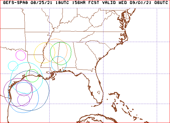
GEFS not only widely spread in distance, also in time. Has members offshore Wednesday morning. These are sub 996 mb lows.