Ed, snow and hurricane fan
-
Posts
2,133 -
Joined
-
Last visited
Content Type
Profiles
Blogs
Forums
American Weather
Media Demo
Store
Gallery
Everything posted by Ed, snow and hurricane fan
-
 I can't imbed Twitter posts anymore. Coastal flooding in Jamaica, the killer will be fresh water flooding in the mountains. Hurricane force gust at airport. ob MKJP 031900Z 10042G58KT 1000 +RA VCSH SCT018 BKN020CB OVC100 26/25 Q1003
 -
Texas 2024 Discussion/Observations
Ed, snow and hurricane fan replied to Stx_Thunder's topic in Central/Western States
GFS and its ensemble suggest significant rain, but not flood producing, or a net positive. GFS develops 96L, (some ensembles do, CMC doesn't but has ensemble members that do) which landfalls farther from Texas, but has a wider precipitation field that produces a large area S of TX 44 of 6 inch rains, @Stx_Thunder -
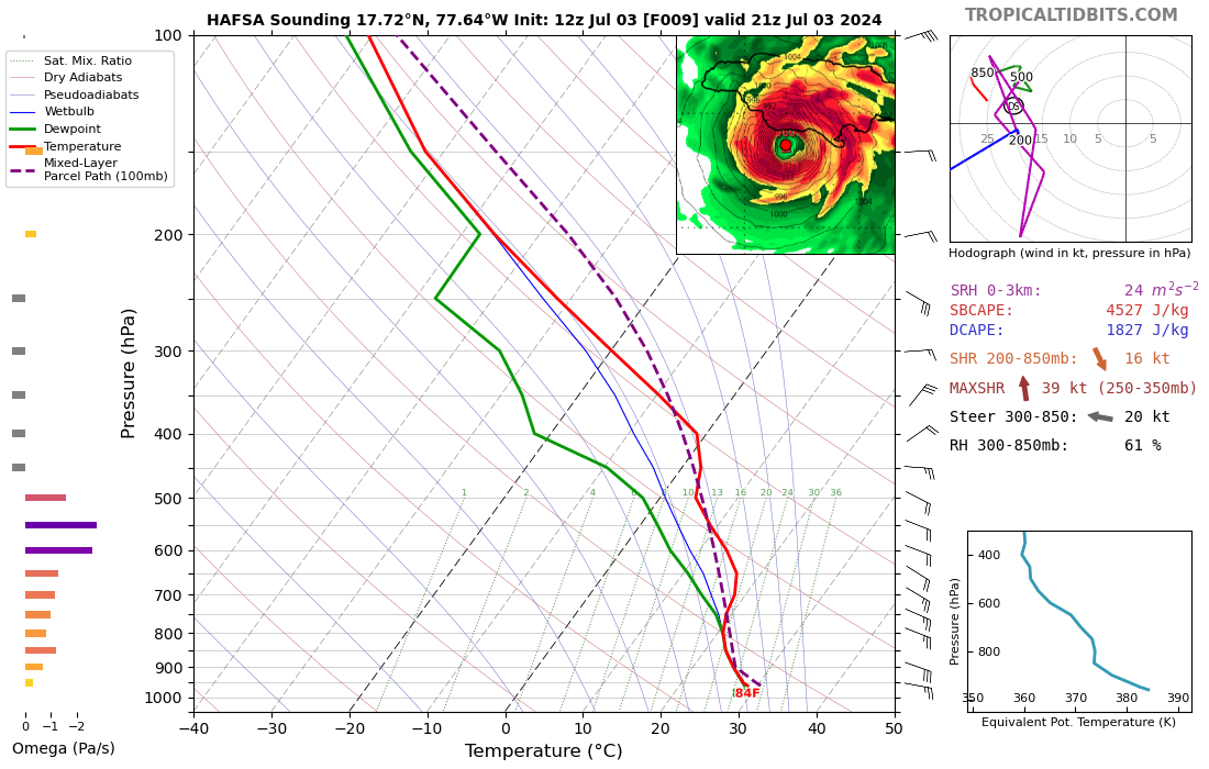
Dry air is close enough to Beryl's NW that an outflow boundary is moving away from Beryl. EDIT TO ADD. Radar shows the eywall is moving onshore in the peninsula SW of Kingston/near Maypen. Kingston should have missed the eyewall. May not even get close to hurricane force winds. https://tgftp.nws.noaa.gov/weather/current/MKJP.html MKJP 031812Z 08023G41KT 5000 RA VCSH SCT018 BKN020CB OVC100 27/25 Q1004
-
I'm trusting NHC forecast of weakening before the Yucatan. Supported by ensembles and the hurricane models. Cat 2 is no picnic, but they aren't uncommon in the Yucatan.
-
It seems possible to me Jamaica might have actually helped slow down the weakening. Deeper convection appeared on the N side which might have been convergence aided. Trying to wrap around the entire eye or remnant eye.
-
HWRF is better on intensity than track, but some of the GFS ensemble members, Canadian ensembles and the op GFS do develop 96L. The HAFS A/B parent grids and op Canadian are not on board yet. Pretty sharp low level wave looking at satellite with good outflow all quadrants but W. NHC not impressed.
-
The 30 knot low level flow is imparting enough shear around 300 mb to be introducing dry air, despite what the shear produced at 250 mb or 200 mb. Forecast valid in 2 hours. Not one GFS ensemble doesn't weaken Beryl significantly before the Yucatan, and the core is now disrupted enough looking at satellite that further weakening seems likely.

-
I have the same about the GFDL. I never kept notes on it, but it seemed like it outperformed the HWRF and HMON. Andy Hazelton, who works with the HAFS w/ NHC's research division, has been noting 'his' models have generally been performing well since introduced. And they should continue. They are even going to introduce ocean-atmosphere coupling, the model would see upwelling under a slow moving storm. It may have already neem introduced, in fact. EDIT TO ADD: If 960 mb is accurate, the weakening is accelerating now.
-
I'm not ruling out wobbles and landfall very near the Rio Bravo del Norte or even N of the Rio Grande. NHC track has shifted by small degrees the last few advisories. I see the historical error cone to Matagorda Bay, which would bring significant surge and rain impacts to Houston/Galveston. But ignoring the ICON and the HWRF, models have been consistent with only small corrections the last few cycles. BTW, 2-4 feet above normal produces flooding that covers the main barrier island roads in Galveston and Brazoria counties. There has already been one such event this season from a uch weaker system.
-
The low level winds causing the shear more so than what the TUTT which is being pushed out of the way doesn't look weaker ahead of Beryl. The usual slowing of the winds enough to add low level convergence doesn't seem like it will help Beryl, or continued weakening until landfall in the Yucatan seems likely.
-
I think the models have started to hone in on a final landfall. The ICON has not been supported by the other globals and the HWRF has not been supported by the other high res hurricane models. Landfall in Texas seems unlikely, the issue now is the impact of the storm in South Texas, and the intensity of the second landfall in Mexico. The GFS shows heaviest rains just missing South Texas. GFS also develops something later (96L?) with a more impactful rainfall event in STX.
-
My understanding is the Jamaica radar has been broken for some time. It may get into range of Cuban radars. http://www.insmet.cu/asp/genesis.asp?TB0=PLANTILLAS&TB1=RADAR&TB2=../Radar/05Pilon/plnMAXw01a.gif
-
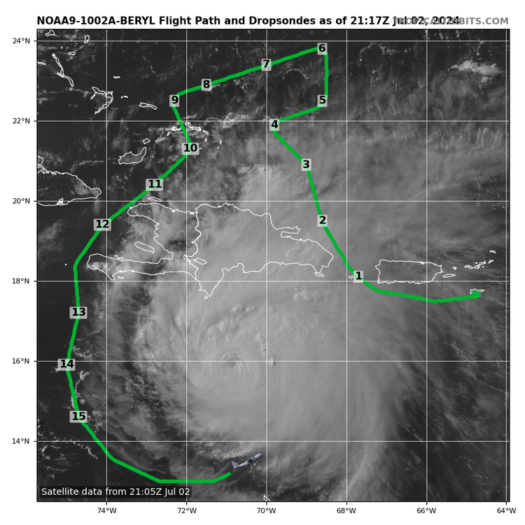
HAFS A & B into NE Mexico. I assume the low level recon and high level sonde drops benefited the runs significantly.
-
Texas 2024 Discussion/Observations
Ed, snow and hurricane fan replied to Stx_Thunder's topic in Central/Western States
NHC track, if stays on or comes N of track, would have weather in South Texas, Reliable models (not the ICON) suggest NHC track is close. NHC does note higher than usual uncertainty related to the ridge strength. Stronger storm in deeper steering likely comes farther N. Multiple variables still at play. -
The overall trend on satellite loops has been a degrading. I will say, recon isn't showing rising pressure yet. Edit: Recon doesn't suggest weakening at all, so far. But the satellite has been degrading. I'm confused.
-
GFS a smidge further N and a smidge stronger, now final landfall at ~975 mb right on the Rio Grande/Rio Bravo del Norte. Canadian is just a bit S of the GFS and somewhat weaker. Waiting on the GFS ensembles but the general idea Tampico to Corpus Christi, with NHC official forecast being supported, is standing if ICON is ignored, and I have never seen an NHC or NWS disco reference the German model
-
Using the Tropical Tidbits loop w/ lat and long, it has moved due W just N of 16*N for four hours.
-
NOAA FL winds to SE still support a Cat 3 storm, near 115 knots at flight level. But that is still weaker than earlier, not a surprise which microwave images posted around the internet. Is there any reason to favor the ICON or at least consider it a peer to the GFS, Euro or even Canadian? Maybe I have bias from a few years back when ICON's main value it was the first available global. Maybe ICON has had an upgrade.
-
It is only the last hour I could see signs the shear limiting the W side convection has finally starting getting to the core. I'd think data further W closer to the TUTT would be useful for predicting how much it does weaken. ECENS still suggest strength in the Caribbean has some influence on track.
-
Texas 2024 Discussion/Observations
Ed, snow and hurricane fan replied to Stx_Thunder's topic in Central/Western States
IAH finally had a 100*F day yesterday. It likely happened between 4 and 5 pm local, when dewpoint had mixed all the way to 69*F, or it was hot yesterday but not horrible being outside. Mins are 81, 80 and 79*F. -
Euro shows the slow final approach I thought might happen, the weakness not turning Beryl much buit weaker steering flow and a slower moving rain maker. Euro ensembles have enogh spread to know there is more than normal sensitivity to small changes than normal.
-
I don't know if it was here, or not, the weakness that splits the ridge that could allow a NW turn toward N. Tamps./STX would also mean weaker steering. Some IMBY or close enough IMBY has me concerned somewhere will have a longer period of TC rains. Motion should be fast enough not for very prolonged rainfalls in Jamaica, just the "normal" excessive rainfall from a TC passing S enhanced by mountainous terrain. Slower motion could be an issue for rain by Yucatan, and I think very possibly the final landfall of whatever Beryl is post shear and land and whatever conditions are in the GOMEX.
-
2024 Atlantic Hurricane Season
Ed, snow and hurricane fan replied to Stormchaserchuck1's topic in Tropical Headquarters
In the deep tropics, so is June. Expecting the next planetary wave favorability period in a month when the oceans are even warmer to not be active because July isn't usually active is bad. The one thing I'll mention, for any pro-mets, I have a week understanding of Rossby and Kelvin waves and even my MJO knowledge is limited. I Google academic papers and don't recall enough physics to understand much of anything. The ability to read engineering and geological peer reviewed papers in my old life enable me to understand many academic papers, but not so much the waves. I Tweet at Dr. Roundy to ask beginner level questions, like, when he thinks the next favorable period starts. His answer was ~4 weeks, and his answer was he expects more activity. -
One would hope 5 days out models would be more consistent. Mentioned on Storm 2K, when an ensemble mean bends sharply right at the end, it is mostly because the S members are running into the rough terrain inland Mexico and being destroyed, so only the members still at sea, mostly right of track are driving the mean. It doesn't mean the consensus of the ensembles is a sudden turn towards TX/LA
-
2024 Atlantic Hurricane Season
Ed, snow and hurricane fan replied to Stormchaserchuck1's topic in Tropical Headquarters
The basin slows down, probably for 4 or 5 weeks, then the next more favorable phase happens, and there should be at least as much cyclone activity since it is closer to the climatological peak.