

Ed, snow and hurricane fan
-
Posts
2,133 -
Joined
-
Last visited
Content Type
Profiles
Blogs
Forums
American Weather
Media Demo
Store
Gallery
Everything posted by Ed, snow and hurricane fan
-
Anybody have a clue whether the GFS or Euro is closer to the truth. Pretty obvious if 7 survives the G. Antilles, it'll 'try' to fish. But will it succeed? A Long Island hurricane is exactly what AmWx needs. Storm Mode and the New England and NYC subforums in a lather. (I live in Houston but was born in NYC and grew up in Massapequa, Belle was one of my happy pre-teen memories. The people in the Hamptons have insurance, I'm sure.)
-
IIRC, back when I paid, and Joe Bastardi didn't just rant on politics, he said the path of WPAC TCs are sometimes mirrored a couple of weeks later in ATL storms. Just on that, Muifa and Nanmadol would suggest 7L could impact the East Coast, I can't remember if Bastardi ever gave a reason, maybe it was empirical, maybe WPAC storms that entered the mid-latitudes further W than usual influenced the East Coast trough/ridge pattern. JB has not tweeted weather today.
-
I don't know how to find the control ensemble member that was initialized identically to the Op, but if that is a significantly different path than the op wouldn't that suggest resolution is a factor in the ensembles not agreeing with the Op?
-
Official NHC forecast is near worst case as far as fatalities go. HaIti and the DR have had major flood disasters before. Grace killed about 2,000 people. The GFS fantasy range Long Island storm is more monetary damage if it happens, but only those that refuse to evacuate are likely to die.
-

2022 Atlantic Hurricane season
Ed, snow and hurricane fan replied to StormchaserChuck!'s topic in Tropical Headquarters
96L is the last legitimate shot at a Texas (Canadian, anyway) hurricane. The season ends at the Equinox. Near perfect rule but a badly sheared 65 knot Jerry in 1989 and a solid Cat 2 that was an EPac TC that crossed into the BoC and hit Freeport at a solid Cat 2 in 1949 shows once every 50 or 70 years, Texas will get an October hurricane. I was at the Cotton Bowl the weekend of Jerry, Texas broke a long losing streak to Oklahoma and won 4 straight years w/ QB Peter Gardere, the only UT QB to beat OU 4 times. -
2022 Atlantic hurricane season whining/banter
Ed, snow and hurricane fan replied to GaWx's topic in Tropical Headquarters
Just because it is 2022, despite looking almost decent, I think the odds 96L makes it to hurricane force is low... -
I see a loose low level center, that is not closed quite yet (the winds blowing clouds from the W are well S of the most obvious turning), and not yet covered in storms, although on the satellite it does look like its trying. The highly respected Korean and Canadian models have hurricane hitting Miami (K) and hitting between Corpus Christi and Houston (C). I suspect they are outliers. Edit to delete redundant vis satellite.
-
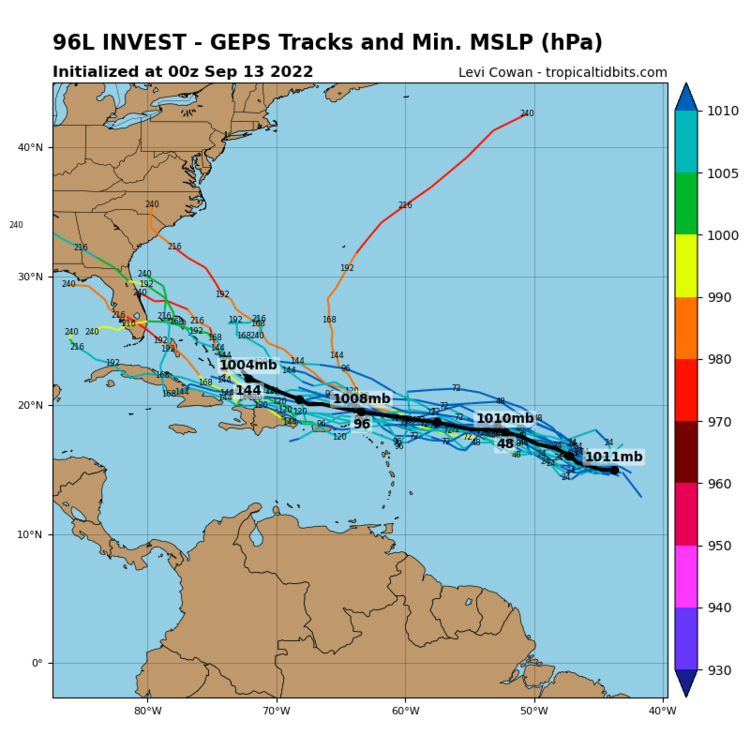
Two of the more reliable globals' ensembles and the Canadian.
-
CMC still having a party, but the reliable ensembles, the weaker systems run into the G Antilles where most die, and the stronger ones recurve. Looks decent on satellite.
-
Why aren't my 2 go to tropical satellite imagery pages not updating?
-
2022 Atlantic Hurricane season
Ed, snow and hurricane fan replied to StormchaserChuck!'s topic in Tropical Headquarters
Probably nothing will happen, but you post hour 384 CONUS GFS maps to prove the tropics are dead. -
GEFS aren't impressed. Canadian and Euro ensembles are impressed. Canadian ensembles destroy some of 96L via Hispaniola, but the ones that avoid the G. Antilles have a chance at Florida. SHIPS is slow developing it, but GFS not seeing much LL vorticity is one of the factors affecting SHIPS. Starting it at 15 knots also would suppress SHIPS intensity. Puerto Rico threat per medium steering guidance used in SHIPS.
-
2022 Atlantic Hurricane season
Ed, snow and hurricane fan replied to StormchaserChuck!'s topic in Tropical Headquarters
The Canadian would make for an interesting thread. I'd post the image, but somehow I can only post files under 10 kb. LDub doesn't seem to have the same limit, how many hour 384 maps of CONUS to prove the tropics are dead. -
2022 Atlantic Hurricane season
Ed, snow and hurricane fan replied to StormchaserChuck!'s topic in Tropical Headquarters
GEFS are rather enthusiastic for an EPac system near Central America, which almost by definition means the Gulf and Caribbean will stay dead. There is a 5 day cherry off Mexico now... -
2022 Atlantic hurricane season whining/banter
Ed, snow and hurricane fan replied to GaWx's topic in Tropical Headquarters
The Washingtonia palm drops a lot of seeds. Give me a few of them and 20 acres of land, in 50 years I can have an oasis. They are native to the Sonoran desert and parts of S. California, they are cold tolerant to near 10F. The native Sabal Mexicana, a variant of the S. Carolina palmetto, laughed at the 2/2021 freeze. Probably why they are native... -
2022 Atlantic hurricane season whining/banter
Ed, snow and hurricane fan replied to GaWx's topic in Tropical Headquarters
Bring on the Autumnal severe season. HOU gets little MAM severe because cold waters over the Northern Gulf mean low clouds and fog, a cap easily broken with a few hours of sunshine in DFW doesn't break here under the stratus. 1992, the slow (except Andrew) hurricane season, produced what I believe are the last F-4 tornadoes in the HGX CWA. In November. It did snow almost an inch in December 2017. February 2021 multi-day freeze w/ rolling blackouts, it drifted in the air like snow, but closer inspection revealed freezing drizzle. And 2021 killed my citrus. I thought my Washingtonia palm died, but it came back after looking dead for a couple of months. When I thought it was dead, when new seedlings came up in April, I planted 5 around my yard. Those puppies grow at least a foot per year, or my yard will look like Florida in 20 years. -
2022 Atlantic hurricane season whining/banter
Ed, snow and hurricane fan replied to GaWx's topic in Tropical Headquarters
I'm sure something will develop N of 30N from an old frontal boundary by the 30th, but I have a funny feeling there won't be another system of tropical origin this month. 17 to 24 October 9/8/22 Euro weeklies show the Caribbean as wetter than normal, but not even October looks exciting. -
Central & Eastern Pacific Thread
Ed, snow and hurricane fan replied to Windspeed's topic in Tropical Headquarters
I remember Cat 5 Linda when there was a question as to whether a trough would recurve it towards Los Angeles. Warmer than normal waters of SoCal. That might have still been a hurricane, based on the E modelling, but I didn't see a major. Been a few years, of course. It missed the trough, obviously. -
2022 Atlantic Hurricane season
Ed, snow and hurricane fan replied to StormchaserChuck!'s topic in Tropical Headquarters
The famous hour 384 GFS. Valid September 27th. CONUS centered. If anything proves a slow October, that isn't it. -
2022 Atlantic Hurricane season
Ed, snow and hurricane fan replied to StormchaserChuck!'s topic in Tropical Headquarters
Posted this in the whining thread, but it could go here as well. In response to a rando 6Z GFS Florida system past 10 days. -
2022 Atlantic hurricane season whining/banter
Ed, snow and hurricane fan replied to GaWx's topic in Tropical Headquarters
6Z GEFS ensembles are just the random popcorn of systems from the SW Caribbean the GFS has a know issue with. I have a smidge more faith in the Euro ensembles with storms N of the Greater Antilles that could either fish or impact the SEUSA, but Euro loses enthusiasm with systems the closer it gets to go time. Euro ensembles at 10 days N of the G Antilles could be the vorticity approaching Florida on the op. Euro But I wouldn't be surprised if there was no tropical development in the ATL through the Equinox. Random Danielle type high latitude sub-tropical formation off an old frontal system, who knows.?. -
2022 Atlantic hurricane season whining/banter
Ed, snow and hurricane fan replied to GaWx's topic in Tropical Headquarters
I went 9 NS only because everybody else was going high. I believed the forecasts of any active season, but this seemed the best way to win. I think 9 is a bit too low, but I think I'm winning. -
2022 Atlantic hurricane season whining/banter
Ed, snow and hurricane fan replied to GaWx's topic in Tropical Headquarters
@ldub23will remind you that people die in car accidents on snowy/icy roads, and while I was on Long Island for the Great Blizzard of February 1978, I saw on the news some people on Route 128 in Massachusetts carbon monoxided themselves to death running the engine for heat in snow over the exhaust. I missed 5 days of 8th grade in Catholic school. When Catholic schools had nuns. -
2022 Atlantic hurricane season whining/banter
Ed, snow and hurricane fan replied to GaWx's topic in Tropical Headquarters
It snowed almost an inch here the December after TS Harvey. (It never produced hurricane winds in the HOU area, although it has lots of short lived tornadoes). That snow fell just before dawn, it was gone by lunch. In the 19th Century Houston had a 20 inch storm, it can happen. Just hasn't happened lately.


