Ed, snow and hurricane fan
-
Posts
2,133 -
Joined
-
Last visited
Content Type
Profiles
Blogs
Forums
American Weather
Media Demo
Store
Gallery
Everything posted by Ed, snow and hurricane fan
-
Original Poster can rename thread.
-
Euro is probably right, Carolinas/Virginia happening, and then you'll feel bad for being such a Debbie Downer. Your neighbors in the VA Capes won't be happy, but you might get your TS/HU you were sure wouldn't happen.
-
Popo's place in Galveston was storm surged/destroyed, but Galveston houses on stilts have motorized storm shutters, and only a few, right on the beach, actually collapsed. All been untouched 14 years. Coastal Florida should be on stilts and motorized storm shutters.
-
Left the Ike plywood outside, it warped. Disposed. I feel a little guilty, besides my birthplace of NYC, TPA is my last weenie wanna see, and Sandy was close enough for NYC.
-
Reed Timmer hyping, and he could be correct, future Ian second landfall and stalling inland NC or VA, a "mega-disaster'. epic flood of all time. His words. 'Mega-disaster'. He had COVID, and maybe a little drunk. He is chasing in Florida. See his YouTube video. He blames his altered state on the anti-virals.
-
I was a Bastardi subscriber then, he is a hype machine, but he talked about a system paralleling the coast being drawn inland. He though LF would be S of TPA.
-
Andrew 5 in Florida and 3 in Louisiana comes to mind. I know Donna, before I was born, brought hurricane force winds to every state Florida to Maine, I suspect more than 1 was MH Edit- no on Donna except Florida
-
Andrew, Michael and Irma?
-
Aircraft has already found two flight level centers. Weaker center WNW of exposed center at edge of the convection.
-
14 years ago, almost a week of no electricity took some of the shine off of hurricanes. Big flood 5 years ago killed family members of a parishioner at my church. Van swept away crossing Greens or Halls bayou One survivor. But TPA, because of the apparent forcefield, wishing harm on no one, but I am-ing just a little.
-
If it is captured by the trough (S. Florida and maybe a second hit OBX or Long Island) I'd think it'd avoid the dry air and be on the upper motion region (and enhanced outflow on the W side of the system) of the trough even before it starts becoming hybrid. S Florida and then up the coast should not weaken other than land interaction, if my simple understanding is correct.
-
I've heard that the state did not bury the powerlines when they forced LILCO into bankruptcy to seize control of the utility. Cat 1 Hurricane Belle in 1976, I thought it was an adventure, Mom having to throw all the food out in the fridge, not so much. Would you road trip to, say, the Hamptons, to catch the eye?
-
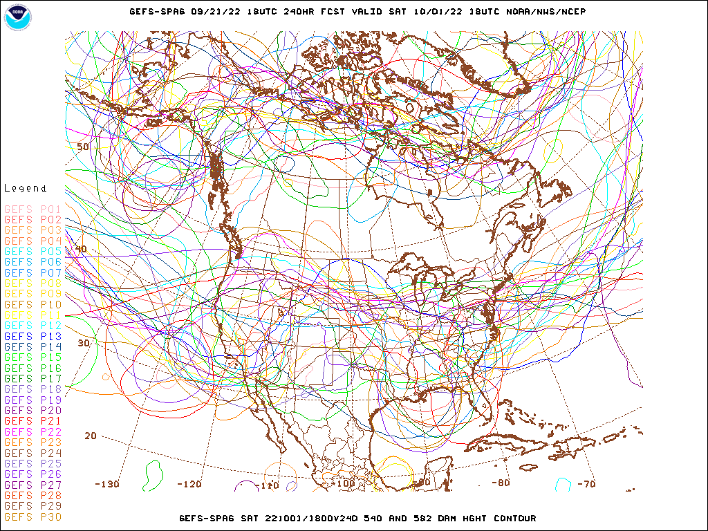
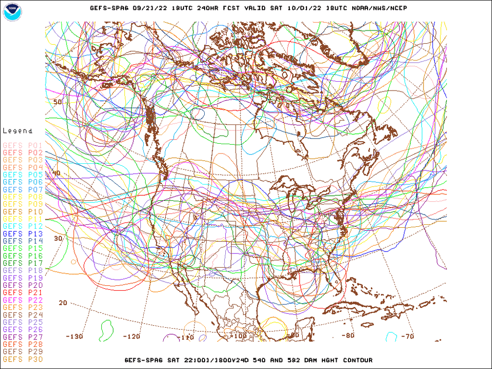
If any two models said I'd be paying the full deductible on my homeowners' insurance in 5 days, I want the German and Canadian models. Sort of pointless except for considering wide areas before a center forms and becomes dominant.
-
6Z GFS was at the extreme W end of the 6Z GEFS, or a shift East, especially if some added HH data ingested, would make sense. I hope Dr. Cowan makes another video today.
-
Per CIMMS, half the LL vorticity is over land. Plus the N shear, almost 30 knots. I think Dr. Cowan is right, won't do much next 2-3 days. He also suggested, because of the shear, if the system somehow strengthens, it will tend to stay further S next 3 days. Or stronger is farther S, not the usual stronger storms go N and E. The 70% 2 day should be reduced, but I can see how NHC would think that is sending a mixed message on what probably is a US threat.
-
Op 6Z GFS landfall between Cameron and Intercoastal City not supported by ensembles. GEFS are mainly NOLA to Florida Big Bend.
-
Yeah ultimately though the low level wave is there and has tilted/folded north, this thing needs convection. That may not come until tomorrow though. Dr. Cowan's video is more like this weekend when shear from the N abates. NHC 5 day probs are reasonable, but this should be a low 2 day orange. My amateur opinion.
-
Nothing in the modelling suggests Texas and in ~150 years, 2 hurricanes, Jerry was a sheared 65 knot Cat 1, 1949 was a cat 2. Maybe its a 50 year return and this is the year, but I don't think so. Spaghetti instead of means, 98L muddles the mean trough, but it is fairly clear in the spaghetti.
-
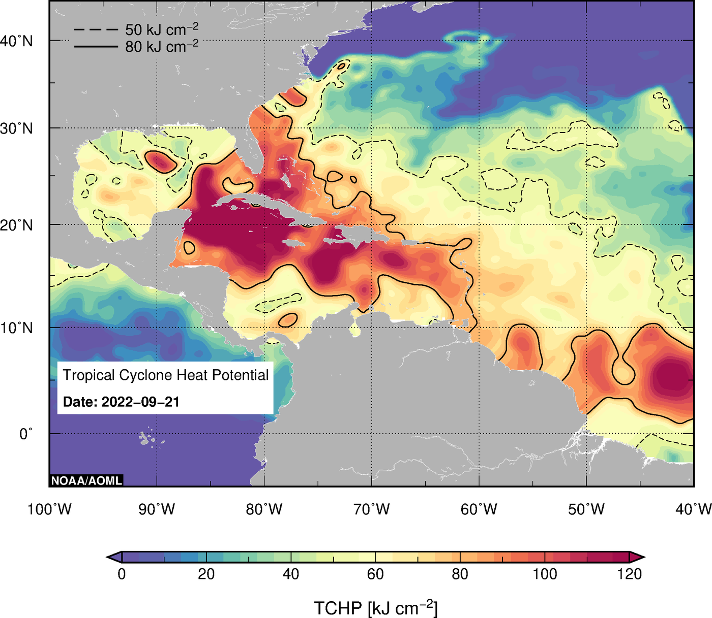
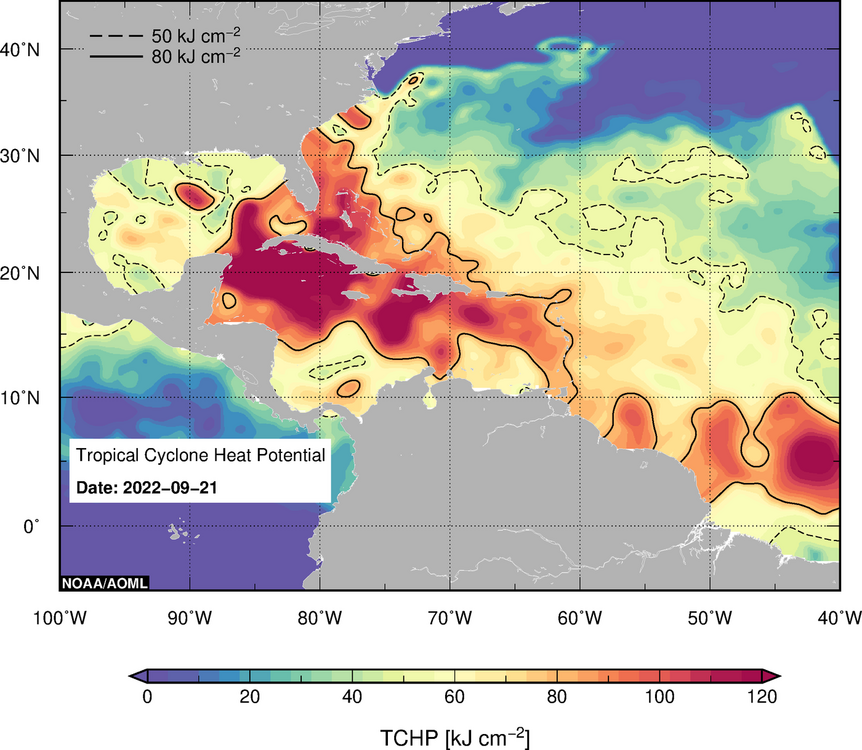
If it parks in that little area of high TCHP S of NOLA.MSY, then gets carried due E towards TPA, well, I'd be full weenie and glad I don't live in Tampa.
-
Imagine the potential if this does come further W towards NOLA
-
The closest thing to an LLC I see will hit Trinidad, if not Venezuela, and there are dry air arc clouds. It may be a monster in a week, but it doesn't look like 70% 2 day odds to me.
-
I don't think the GFS changes SST/OHC based on winds as longer range climate models do. But I could be wrong.
-
The GFS weakening at landfall makes sense, except that would likely be because of offshore winds (from NE) ahead of then Hermine would be pushing water into the Gulf and upwelling cool water, and I don't think (I could be wrong) the GFS changes SST/OHC, ie, not coupled
-
I am wondering if interaction with S America may slow down 98L more than the 2-3 days likely development of the TWOAT.
-
The one thing about a storm almost paralleling the Florida West Coast, remembering Charley, they'll need to have a larger than normal area in the H Warning (assuming the 9 and 10 day Euro verifies). A near miss offshore, judging by the shape of Tampa Bay, would still be a major surge issue. I'm feeling WC Florida or Panhandle, but enough GEFS get the Atlantic side or reach the Carolinas, they aren't in the clear by any means.