Ed, snow and hurricane fan
-
Posts
2,133 -
Joined
-
Last visited
Content Type
Profiles
Blogs
Forums
American Weather
Media Demo
Store
Gallery
Everything posted by Ed, snow and hurricane fan
-

2023 Atlantic Hurricane season
Ed, snow and hurricane fan replied to Stormchaserchuck1's topic in Tropical Headquarters
Airplane this afternoon. Early activity in El Nino from non-tropical origins explained by Dr. Roundy -
2023 Atlantic Hurricane season
Ed, snow and hurricane fan replied to Stormchaserchuck1's topic in Tropical Headquarters
10/20 lemon in the Gulf, not tropical feature. 1997 Super Nino, 4 June/July storms, none of tropical origin, before the season died, no storms in August, total of 7 for the season. Not sure if there is a link between developing strong to super Ninos and early activity from non-tropical origin. -
2023 Atlantic Hurricane season
Ed, snow and hurricane fan replied to Stormchaserchuck1's topic in Tropical Headquarters
I'm on Team USA for this one. -
2023 Atlantic Hurricane season
Ed, snow and hurricane fan replied to Stormchaserchuck1's topic in Tropical Headquarters
30/30/40 odds of normal, above and below doesn't seem like a very bold prediction. Thinking of the Klozbach early April out;ook, where he didn't know how strong Nino would get and how a warm Atlantic MDR would counter the tendency to suppress storms, so he split the difference, it getting closer to Summer, SOI is finally acting like it should for a wamr ENSO, and the PDO is changing to reflect the equatorial temps. I'm trying to find a comparison between current Atlantic warm anomalies vs this time last year. I doubt they have gotten warmer in the last year, but my Google fu is weak. A couple of years ago, I could switch years in the Gregorian number in the URL to compare one year to the next, but for whatever reason, AOML seems to have made that password protected/ -
El Nino 2023-2024
Ed, snow and hurricane fan replied to George001's topic in Weather Forecasting and Discussion
Since I assume climate models change (are tweaked, adjusted, what have you) in 8 years, a warm bias from 2015 may not still exist now. -
Worse the two counties to the N
-
Jim Edds will have a daytime intercept.
-
Nice outflow boundary, gusty winds, a little thunder and 20 drops of rain FM 1960/TC Jester region N Houston.
-
BULLETIN - EAS ACTIVATION REQUESTED Tornado Warning National Weather Service Houston/Galveston TX 322 PM CDT Tue May 23 2023 The National Weather Service in League City has issued a * Tornado Warning for... Central Montgomery County in southeastern Texas... Southwestern San Jacinto County in southeastern Texas... * Until 345 PM CDT. * At 322 PM CDT, a severe thunderstorm capable of producing a tornado was located over Panorama Village, or over Willis, moving southeast at 40 mph. HAZARD...Tornado. SOURCE...Radar indicated rotation.
-
I wonder if the earlier bend W increases the threat to the Philippines, although most GEFS members recurve before landfall.. Cat 3 over or near miss of Guam is a big deal. Looking at maps a few days ago, I forgot all about Guam because it is so small. I spent a couple of hours in Guam, in the airport.
-
Adjusted to 10.5/ 4.5/ 2
-
Not a super typhoon per JTWC (70 knots), but I can get satellite images into the thread without using up more attachment space with Twitter. GFS does get it to 915mb next weekend. GFS and ensemble mean are a near miss for Luzon.
-
2023 Atlantic Hurricane season
Ed, snow and hurricane fan replied to Stormchaserchuck1's topic in Tropical Headquarters
Has some very weak Euro and GFS ensemble support. Not impossible it could become a weak named STS. I think the first lemon of the season -
El Nino 2023-2024
Ed, snow and hurricane fan replied to George001's topic in Weather Forecasting and Discussion
I used to be a subscriber, both AccuWeather, and WxBell of JB. Weather Bell tripled my intro rate, and JB's focus shifted to politics. I agreed with a lot of his politics, but he went down the DJT rabbit hole, and I was paying for weather, not politics. Did I mention WxBell tripled my annual subscription? Anyway, I don't think he operates for clicks or retweets. I know only amateur weenies are supposed to wish-cast, but he is a degreed wish-caster. He sees hurricanes every year in the Northeast because he grew up in Rhode Island, and also sees snowy winters. But because it is what he honestly wants. Just my opinion. Maybe he is monetizing weenie-ism, but I don't think he thinks that is what he is doing. -
TS Mawaw (it will be called Betty in the RP) when it enters Pagasa area of responsibility) may be a threat to the Philippines in a week. I don't have the attachment space to post the GIF, but it is looking good. https://www.tropicaltidbits.com/sat/satlooper.php?region=02W&product=ir Sub 920 on GFS in a week. Op GFS and Euro are a near miss N of Luzon, 0Z Euro ensemble is close. Re file name, Pagasa uses Filipino names, usually English or Spanish, and are a lot easier to remember than the WMO names of WPac cyclones.
-
2023 Atlantic Hurricane season
Ed, snow and hurricane fan replied to Stormchaserchuck1's topic in Tropical Headquarters
2006 would make by contest predictions pretty good. I don't pretend to understand all the Tweets, but these guys sound like they know what they are talking about. The balance of a 1997 Death Niño against an abnormally warm Atlantic. -
I'm still feeling somewhat below normal, based on what will be a super ENSO event (although there is useful discussion on the ENSO thread that warm anomalies outside the ENSO 3.4 region may change the expected atmospheric response. Below normal, but not super-bearish. Euro forecasts don't show what I'd expect from a 97ish ENSO, but then again, almost all the oceans are shown with decent probability of above normal SSTs. I'm staying 9/4/2 because it looks like many are going normal (~14, 7, 3) so I'm separated from the pack. The above NY/New England comment, I'm aware the chance in any one year is low. Not pictured, 3 month Euro 500 mb heights, the whole world is normal to above normal with a few small areas with some probability of below, which doesn't seem possible. The whole world can't have higher than normal 500 mb heights, can it?
-
9/4/2. Betting on a 97 El Nino. 11 years since Sandy, I teach statistics and probability, I know 'due' is not science, but I don't care, NY/New England are due. One of the 4, maybe even the 2, through E Nassau and into Connecticut, and just W of the river into Massachusetts.
-
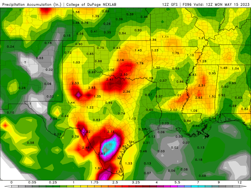
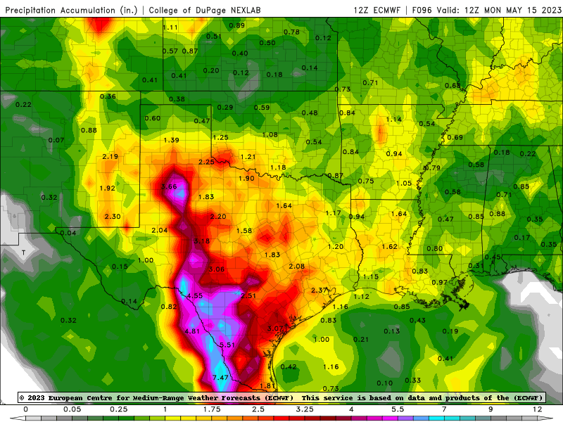
GFS has changed little. San Antonio and Guadalupe rivers in the Coastal Plain already approaching moderate flood. Although the heaviest (5 to greater than 7 inches in 5 days) bullesyes are S of the San Antonio and Guadalupe rivers, they are still at looking 2-5 inches
-
Severe Threats 5/10 thru 5/12
Ed, snow and hurricane fan replied to Quincy's topic in Central/Western States
It produces wall clouds, but refuses to produce for Timmer. -
Severe Threats 5/10 thru 5/12
Ed, snow and hurricane fan replied to Quincy's topic in Central/Western States
Reed Timmer in the Dominator is on it. -
Some differences in models, but widespread 5 inches along the Rio Grande from the Big Bend to the coast threatens major flood in South Texas and Coahuila and Tamaulipas.
-
El Nino 2023-2024
Ed, snow and hurricane fan replied to George001's topic in Weather Forecasting and Discussion
This is a how much for Philly question, it looks like it'd take some serious internet research, (I did some Google w/o much luck) I remember the 97 hurricane season, but how was Winter 97-98 in Texas? Warm ENSO is supposed to mean cooler with better chance for snow (Cold ENSO is warmer and drier, but the last few super-freezes were La Nina years), but I don't know if a Super Nino is even cooler, even more wet, and an even greater chance of a measurable snow. 2017 was the last measurable snow in Houston. 2021 might be the official one, but that was frozen drizzle. I learned this year NWS counts any frozen winter precip as snow. -
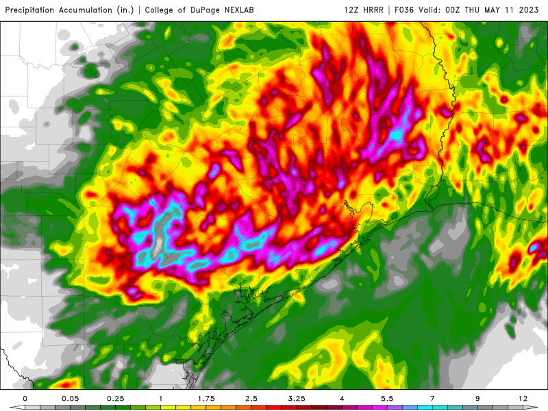
Moderate Risk SETX of flash flooding. HRRR 36 hour rainfall, 5-7 inch bullseyes near Houston, 9 inch E/SE of San Antonio. What will the San Marcos and Guadalupe rivers do?