

Ed, snow and hurricane fan
-
Posts
2,133 -
Joined
-
Last visited
Content Type
Profiles
Blogs
Forums
American Weather
Media Demo
Store
Gallery
Everything posted by Ed, snow and hurricane fan
-

2023 Atlantic Hurricane season
Ed, snow and hurricane fan replied to Stormchaserchuck1's topic in Tropical Headquarters
CIMSS MIMIC TPW product already shows lower PW air being drawn into the disturbance SW of the CVs. I don't think the GFS is far from wrong showing that wave disappearing in the dry air. It wouldn't be the first good looking wave that quickly disappears this year. I think there is a much higher chance of something subtropical, not yet well modeled, forming off the East Coast, than anything MDR, for at least a week. -
2023 Atlantic Hurricane season
Ed, snow and hurricane fan replied to Stormchaserchuck1's topic in Tropical Headquarters
I don' really see CSU coming close to verifying. Op GFS still going 16 days w/o a named storm, ensembles are kind of 'meh', and there seems to be a lot of dry air Central/Eastern MDR. Where the upper convergence/subsidence is. What activity the GEFS do see seems to form past 50W. Yesterday's Euro weeklies still seem to like late August for W based systems that could be close enough to ECUSA to be interesting. -
2023 Atlantic Hurricane season
Ed, snow and hurricane fan replied to Stormchaserchuck1's topic in Tropical Headquarters
The op Euro tries to develop something from the 3 clusters of storms offshore and nearshore Africa. Middle level RH just N of the system is dry, but I think the issue is shear. The disturbance is just S of an anticyclone which has low shear under the anticyclone but higher shear (rising in a short distance to over 20 knots) from the E just S of the anticyclone, over where best mid level RH is. 18Z GFS version is the wave moves out of the good moisture and dies in the desert. The three blobs thing also may mean the system is strung out (TPW product suggests it as well), which seemed to be part of the issue with 95L and 06L. But with some ensembles and the op Canadian develop something, it may provide something to talk about the next two weeks. Especially with Euro ensembles showing a couple of mid Atlantic landfalling cyclones in 2 weeks -
The larger number is based on Lanza's forecast. The local Houston TV station with 10 day forecasts are calling for >100 °F every afternoon. Not that there is a big cool down in 11 or 12 days for Houston and Dallas if he is forecasting SAT to remain above 100 °F for the full 15 days of the GFS and various ensembles (at least seems to suggest he doesn't see the pattern changing. Also of note, red flag warnings from the San Antonio-Austin NWS office and critical fire danger over most of N Central Texas on SPC Day 1 outlook.
-
2023 Atlantic Hurricane season
Ed, snow and hurricane fan replied to Stormchaserchuck1's topic in Tropical Headquarters
The op shows a lot of dry mid-level (700-300 mb) air, which is what seems to stop each wave. Not sure why the Atlantic is so dry, although downward motion is over the basin more often than upward motion, and sinking air will compress and heat up and have lower RH. The general downward motion may be El Nino related. One of the mets could confirm/elaborate -
El Nino 2023-2024
Ed, snow and hurricane fan replied to George001's topic in Weather Forecasting and Discussion
It seems like this year was an acceleration of the trend of warming. The Tonga eruption last year put an estimated 55 million tons of water vapor, a greenhouse gas, into the stratosphere. Early discussions just how the gradual warming of the last 30 years might shift some expected ENSO response/coupling, and then add in a volcano putting a greenhouse gas into the stratosphere, and not fine ash and sulfur dioxide which reflect radiation back into space. Mentioned often in this thread, not many analogs for a strong or super Nino with much above normal Atlantic temps. -
I'm not sure I have ever seen cumulus buildups when it is 105°F (at DW Hooks, 101°F at the big airport) I doubt we'll see any rain (although I'd guess some lucky town somewhere in the Houston area will get some rain with gusty winds (30°F T/Td spread)) Edit- I've been in Monahans, TX, when it was over 110°F and dry lightning started a large brush fire, I don't know if the HGX area has ever had a dry lightning grass or forest fire. I was in Monahans the day they tied the Texas all time record of 120°F. Summer job, outside, in the oilfield. Nomex (fire resistant) clothing. 1994.
-
2023 Atlantic Hurricane season
Ed, snow and hurricane fan replied to Stormchaserchuck1's topic in Tropical Headquarters
FWIW, Canadian ensembles also have a strong signal for a Central American Gyre that produces storms in both basins. I don't usually look at the GEPS. I don't know if GEM (and its ensembles) have improved in the last few years, about 10 years ago it was like using the NAM in the tropics. -
El Nino 2023-2024
Ed, snow and hurricane fan replied to George001's topic in Weather Forecasting and Discussion
@brooklynwx99 CanSIPs on the free TT doesn't have 200 mb velocity potential. At least I can't find it. Do you have ASO and/or A, S, O plots. Down here DJF and ENSO is the difference between a mild, dry winter and a cool rainy winter. Ninas are warmer, on average, but all the severe cold snaps (low temps 20F and colder) seem to happen in Nina years. -
2023 Atlantic Hurricane season
Ed, snow and hurricane fan replied to Stormchaserchuck1's topic in Tropical Headquarters
The trough along the East Coast looks to move W towards the central Great Lakes/Ohio Valley toward mid-month. I suspect the Atlantic remains unfavorable with subsidence and dry air, but it would seem unlikely nothing at all (perhaps a non-tropical system becoming tropical) develops in the second half of August. The Euro weeklies change a bit from run to run, but generally hint at activity near ECUSA latter half of August. Hint of something not tropical on op GFS, an area of moisture with a very weak upper level disturbance near 40N/60W day 8 drifts SW toward the Bahamas around day 12, and from there, it looks like a standard tropical wave. Moves across Florida, starts to organize in the Gulf, runs out of time. Not to rely on a single op run, (hi, @ldub23) much of the run beyond the 10 day resolution truncation., but close in developments, maybe around the Bahamas, with higher heights to the E. (That would bring back fond memories of 1976 and Hurricane Belle)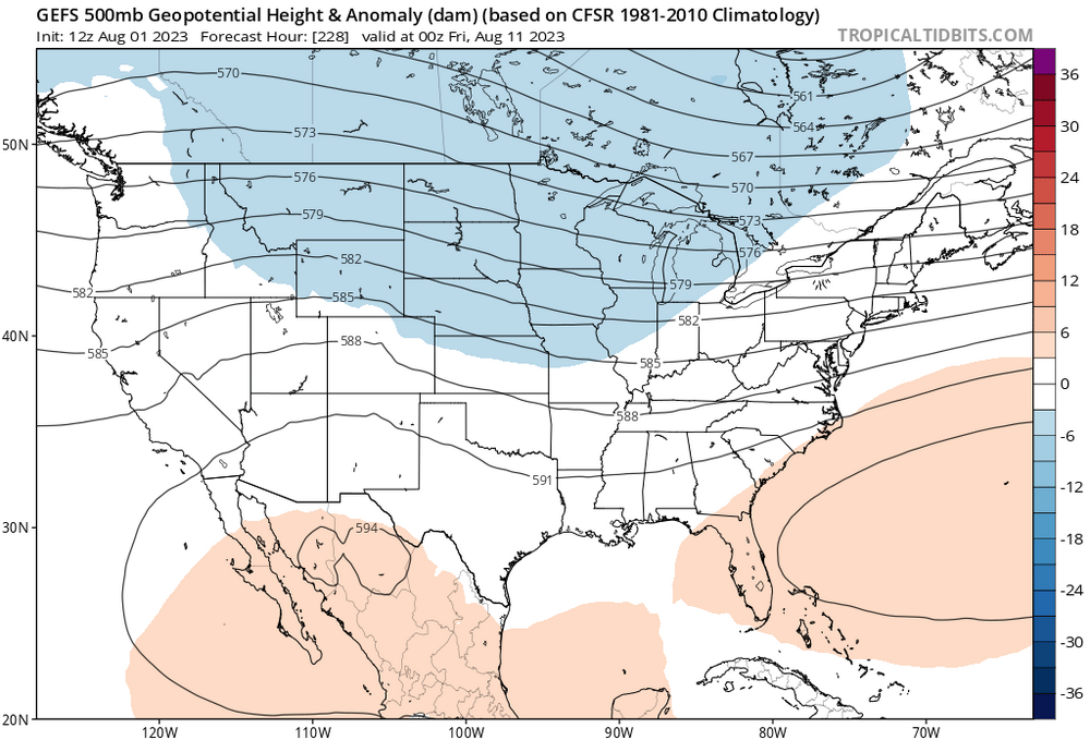
-
2023 Atlantic Hurricane season
Ed, snow and hurricane fan replied to Stormchaserchuck1's topic in Tropical Headquarters
Euro weeklies the last week do seem to see an enhanced risk the end of August along and offshore ECUSA. Weekly 500 hPa forecast Not shown) for that time, the trough is over the Central/Eastern Lakes down into the Appalachians, with higher than normal heights in the Canadian Maritimes. -
Houston forecast high of 104 °F today would be the warmest day so far this summer.
-
Taunton in a severe t-storm warning. Just checking in to see who was discussing that.
-
No sign the drought anywhere in the state will improve anytime in August judging by Euro and GFS weeklies. Forecasts are as hot as anytime this summer.
-
2023 Atlantic Hurricane season
Ed, snow and hurricane fan replied to Stormchaserchuck1's topic in Tropical Headquarters
Nothing on the Euro or GFS ensembles after 96L and the possible off the Carolinas sub-tropical system. If anything develops 10-15 days out, I'd guess it'd be subtropical. 8/21 to 8/28, a small signal on the Euro weeklies for something off the ECUSA. Speaking of 96L, SHIPS is as optimistic as any intensity guidance gets, and that is barely Cat 1 intensity. -
2023 Atlantic Hurricane season
Ed, snow and hurricane fan replied to Stormchaserchuck1's topic in Tropical Headquarters
Double the usual expected ACE for the week of 8-21 to 8-28 per today's Euro weeklies. TC probs, the weeklies see 96L but aren't seeing the EC sub-tropical development the ensembles clearly see. Maybe it does see it in the rainfall anomalies, but not in the TC percentages. About the week of 8-21, perhaps hints of Florida being affected in rainfall anomalies.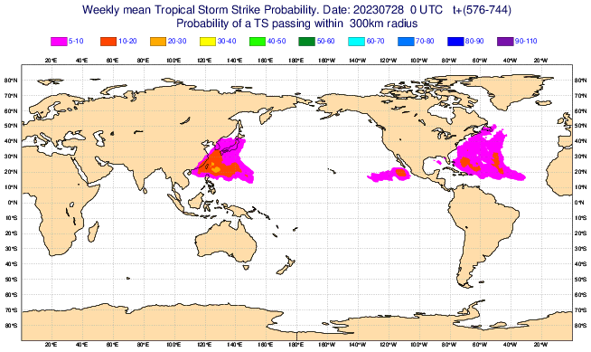
-
2023 Atlantic Hurricane season
Ed, snow and hurricane fan replied to Stormchaserchuck1's topic in Tropical Headquarters
As long as fronts can stall and decay E of Florida, ECUSA is not 100% safe. No model support for today's Bahamas blob, but it probably isn't the last Bahamas blob of the year. Even an MDR system could miss the trough. Last two weeks of Euro weeklies have a >5% TC chance along ECUSA. -
The dry front produced only very isolated storms over the weekend, and the official Houston high temp was 100*F. TV forecasters had been excited all week about the weekend's rain chances and cooler weather.
-
This may or may not be the page people are using, but I can't get the images with analog years and the such I see people post in threads. https://psl.noaa.gov/data/gridded/data.ncep.reanalysis.html
-
2023 Atlantic Hurricane season
Ed, snow and hurricane fan replied to Stormchaserchuck1's topic in Tropical Headquarters
You haven't seen the GFS and Euro ensembles, or the op Euro. I agree 10 hurricanes seems high to me, Euro weeklies don't look very active into early September (although the ACE product is normal to somewhat above normal) but it isn't dead heading into August. Not a slam dunk, only a few GFS ensemble members see it but the Euro system is a big deal if it is just N of the Greater Antilles instead of through it. That system, if it forms, probably fishes, but ten days out, who knows? -
2023 Atlantic Hurricane season
Ed, snow and hurricane fan replied to Stormchaserchuck1's topic in Tropical Headquarters
I think it is the wave just past 0 degrees the models like a lot more than 95L. -
El Nino 2023-2024
Ed, snow and hurricane fan replied to George001's topic in Weather Forecasting and Discussion
I saw something above about how strong Nino forcing would be for winter, and it does look like it peaks before Thanksgiving (1.761 is the highest 3 month dynamic mean off IRI, in SON). Is it me, or is this Nino rather abrupt in its rise and fall? -
2023 Atlantic Hurricane season
Ed, snow and hurricane fan replied to Stormchaserchuck1's topic in Tropical Headquarters
Edit to add- I just noticed 95L. Its the MDR lemon. FWIW, SHIPS brings it to a 101 knot Cat 3 in a week. I doubt that. Original post below, Euro weeklies suggesting TWC 20 storms isn't likely. The Euro weeklies don't seem to support The Weather Channels 20 named storms, at least not into early September. They also seem to suggest the next two weeks will actually be the best chance of much. They are picking up on the lemon that Euro ensembles are showing, and maybe something behind it, and then I don't see anything suggesting TC activity after. The Caribbean looks dead, I assume a product of a trough near the East Coast and El Nino shear. -
2023 Atlantic Hurricane season
Ed, snow and hurricane fan replied to Stormchaserchuck1's topic in Tropical Headquarters
The ensembles at hour zero seems to show the multiple disturbances. CIMSS TPW looks a bit better for the 39W wave than the NHC wave. -
It was 100°F at Bush/IAH, but dewpoints mixed down to 71°F, it could have been worse. 2°F short of the 1980 record. I don't think Houston has broken a daily record yet. 98°F at 4pm. Nothing astounding, but GFS and Euro ensembles show some rain next weekend.


