Ed, snow and hurricane fan
-
Posts
2,133 -
Joined
-
Last visited
Content Type
Profiles
Blogs
Forums
American Weather
Media Demo
Store
Gallery
Everything posted by Ed, snow and hurricane fan
-

2023 Atlantic Hurricane season
Ed, snow and hurricane fan replied to Stormchaserchuck1's topic in Tropical Headquarters
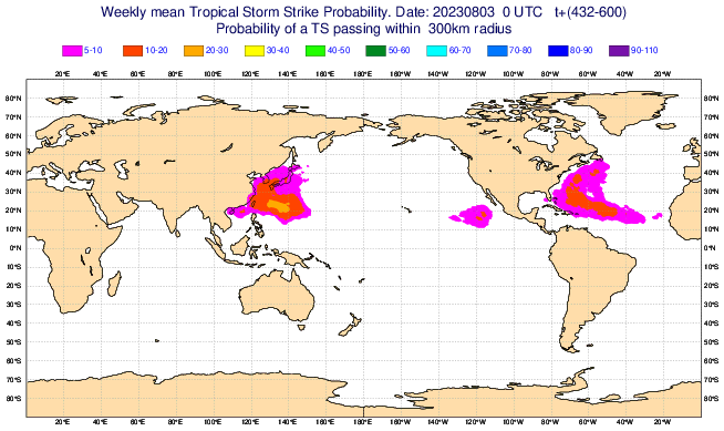
Recurvature seems to be a GFS ensemble trend as well for the members that develop a cyclone. IMBYish, I'm wondering why various ensemble families seem to like the Caribbean/Gulf and SEUSA near/after 10 days. Even if I reject the GFS Gulf ensemble members that develop a storm out of the SW Caribbean (coming of S America?) as a known GFS model family issue, Euro/CMC/GFS family all suggest something becomes more conducive to development in the W part of the basin. -
2023 Atlantic Hurricane season
Ed, snow and hurricane fan replied to Stormchaserchuck1's topic in Tropical Headquarters
Mid August and the GFS tries a couple of times, but fails, no TCs through 16 days. Even CMC is two weak systems at 10 days, down from 4 yesterday. OTOH, CFS weekly shear in the Caribbean doesn't look Nino-ish. A few GFS develop weak cyclones in the E Gulf in 5 days, I don't know if that is the little wave E of the Bahamas, or maybe something on the tail end of the trough/weak cold front. Wishcasting that, a 1007 mb depression into Texas would be just what the doctor ordered after 7 weeks of no rain and temps near/above 100F for a month. Ensembles like one of the freshly offshore or soon to be offshore waves (see picture), even if the op doesn't, maybe that gets us one named storm by this time next week. New post while I was typing, inspires the question, is there a wave on satellite that is the seed of the Gulf activity? Some of the TT ensembles look to develop something in situ in the Gulf, more move something out of the Caribbean, starting near S. America, and I tend to have issues with the GFS seeming to develop things coming off South America. I don't know why, the resolution is low to begin with and doesn't change, but the ensembles get funny, IMO, after about 12 days. In its defense, Canadian ensembles start liking the Caribbean, then the Gulf and off Florida, past 10 days. -
2023 Atlantic Hurricane season
Ed, snow and hurricane fan replied to Stormchaserchuck1's topic in Tropical Headquarters
I consider the GFS a 'super control' ensemble member past hour 240. It is showing what could happen in ten to 16 days. Op runs shuuld be like CMC and Euro, 10 days. Takeaway for me is the tropics get active in another ~10 days, several waves that could develop, and then the season shuts down less than a month later as El Nino takes control with increased Caribbean shear (I don't understand which image is which, scales, or where they came from, but the Danny Morris post above that the Nino like shear, beginning of month shown to start early September, is pushed back to mid September). I had to check, and yes, somebody posted the 384 simulated IR of the model's Cat 4 or Cat 5 hurricane approaching Louisiana on Twitter. Maybe another reason the model should run to 10 days, the freed up computer resources, maybe run the model at a finer resolution and use more complex physics and fewer simplifying assumptions. And fewer scary images on Twitter. -
0Z GFS post cold front makes Houston hotter, per GFS, Temps low 100s°F Tuesday go to mid 100s Wednesday and Thursday. Dewpoints drop to perhaps upper 40s in Wednesday afternoon, so heat index shouldn't change. NWS forecast is for 20% T-storm chances Tuesday with no change in temperatures. A few splotches of .05 inch rainfall in SETX, outside of the Panhandle nobody in Texas does better than a quarter inch in the next week. Last rain in Houston was July 6, or wildfire risks should only climb.
-
2023 Atlantic Hurricane season
Ed, snow and hurricane fan replied to Stormchaserchuck1's topic in Tropical Headquarters
I don't know what site images are from, the specific days, or anything else that would usually be part of a map legend, but he seems one of the better amateurs on Twitter. Main point is the arrival of El Nino shear may be delayed. -
2023 Atlantic Hurricane season
Ed, snow and hurricane fan replied to Stormchaserchuck1's topic in Tropical Headquarters
85 was a easing Nina, '08 was a neutral after Nina season. This year, a building strong to super Nino. But hey, Hurricane Gloria and Hurricane Ike, sure, all the signs are there. Did I mention his dad taught an hour (on a Sunday) from Houston and he spent a few years in Texas, and his family is from Rhode Island. I'm disappointed 1954 isn't a JB analog. Edit- 1954 was mentioned. Edit 2- Euro weeklies TS probs suggest there will be activity near (or impacting) ECUSA -
2023 Atlantic Hurricane season
Ed, snow and hurricane fan replied to Stormchaserchuck1's topic in Tropical Headquarters
Joe Bastardi is not the best follow. Andy Hazelton and the posters he responds to tend to have more insight, IMO. JB was ok when I subscribed to AccuWeather, he talks less weather and more politics now, and the weather posts seem designed for clicks. JB is a fine follow if you want to believe a sudden increase in undersea volcanism explains record warm ocean temperatures. With 3 or 4 of the 50 (or is it 51, 50 perturbed members and a control run?) still showing a TD (pressures above 1005 mb) into the Gulf early next week, I'm going to watch the one thing that has a chance, albeit miniscule, for a TC in the next week. It feels weenie to follow such a low odds thing, but I'm old enough for the US Olympic Teams 'Miracle on Ice' against the USSR's Red Army Team. -
2023 Atlantic Hurricane season
Ed, snow and hurricane fan replied to Stormchaserchuck1's topic in Tropical Headquarters
More Autumn/Winter tropical cyclones (of limited intensity because late October through January storms that form past the point of when conditions are favorable for stronger storms). And heat transfer from the tropics/subtropics from higher dewpoint/theta-e air from the tropic/subtropics into winter and spring storms. If winter tornado outbreaks becoming more common is a definition of 'wild weather', it might be happening already. December Kentucky tornado outbreaks, January having the strongest tornado in Harris County (South Houston/Pasadena) in 30 years. -
2023 Atlantic Hurricane season
Ed, snow and hurricane fan replied to Stormchaserchuck1's topic in Tropical Headquarters
Or perhaps (I mentioned an HRD scientist's theory of distortion of Hadley Cell by warming higher latitudes and wave breaking) the heart of the season isn't ASO anymore, more like SON or more likely just SO. The difference this year and last year, which became quite active in September, is the likely effects of an El Nino that is strengthening. Neutral or weak cool ENSO 2024, September is probably not so hostile to TCs. I do think the 160 ACE and 18 named storms aren't happening. This year. But anyway, my previous post is the very unlikely chance of Gulf development next week. Not an ACE generator, but maybe at least South Texas gets some rain as a 2011 Texas fire season becomes more likely. I think Houston has a real shot of breaking the 2011 24 consecutive days AOA 100F this year. 2011 was almost California like in property destruction from wildfires. -
2023 Atlantic Hurricane season
Ed, snow and hurricane fan replied to Stormchaserchuck1's topic in Tropical Headquarters
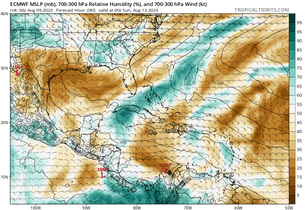
Euro ensembles suggest an uptick in 7-10 days, but that has felt a little Charlie Brown and the football. Near term and lower prob, zero GFS ensemble support, rather tepid Euro ensembles, a very weak wave now near 65W becomes a bit better defined in 3 1/2-4 days near W Cuba, maybe finds a small window of shear and dry air, TD or TS for N. Mexico or Deep South Texas.
-
2023 Atlantic Hurricane season
Ed, snow and hurricane fan replied to Stormchaserchuck1's topic in Tropical Headquarters
It took me a few minutes. they seem to allude to the weeklies, but mostly it should get busy soon because this is the time of the year it should be about to get busy. 30 minutes. -
2023 Atlantic Hurricane season
Ed, snow and hurricane fan replied to Stormchaserchuck1's topic in Tropical Headquarters
Verbatim, those 2 lows will be struggling bigly with dry ait. August 21 to Sept 4, the Euro weeklies like along and off ECUSA, maybe something changes. I watched a Twitter video, a Savannah, GA TV met. He thinks the season will pick up in 2 weeks, but he based that mostly on climatology. The season 'should' pick up because most seasons do. I'm not sure what is supposed to change. Dry air doesn't seem like it is going anywhere soon.
-
NWS forecast around Austin (and the general theme applies to anywhere I-35), temps about 105, with afternoon winds 15 G 25. They've been containing the fires quickly so far, everyone has been quite vigilant, but 2 more weeks of this, it seems likely there'd be at least 1 fire like the Possum Kingdom or Bastrop fire. SPC critical fire and/or local NWS Red Flag warnings covering much of the state.
-
2023 Atlantic Hurricane season
Ed, snow and hurricane fan replied to Stormchaserchuck1's topic in Tropical Headquarters
Euro weeklies do show chances of a TS, but less than 5%, call it nil, chance of a hurricane in the next four weeks. I don't think @ldub23's 0/0/0 August works out, and I still think there is probably a hurricane, but the odds of 0/0 H/MH are growing.
-
Louisiana isn't in the Southeast or Mid-Atlantic, and I'm in Texas and closer to Lake Charles than to Dallas, so I'd say this is the place to post Louisiana weather.
-
2023 Atlantic Hurricane season
Ed, snow and hurricane fan replied to Stormchaserchuck1's topic in Tropical Headquarters
The wave (LDub's lower right) still looks impressive, but I suspect it will do as all the waves have done (see 45W), weaken (dry air, and maybe warm mid-levels (abnormally high 500 mb heights in the tropics seem to get everyone) and weaken. Euro ensembles are looking pretty inactive into mid August -
2023 Atlantic Hurricane season
Ed, snow and hurricane fan replied to Stormchaserchuck1's topic in Tropical Headquarters
I am curious what data made the models yesterday and lasr night that had them (and especially the ensembles) bullish for development a week to two weeks out, when they had not been seeing much TC activity before, and again today. It wasn't just one model suite. Maybe the lesson is I need two full days of multiple model enthusiasm. Maybe three, before I buy in. -
El Nino 2023-2024
Ed, snow and hurricane fan replied to George001's topic in Weather Forecasting and Discussion
Based on his hypothesis, I wonder if the 2022 season switched back on in meteorological autumn because the higher latitudes were cooling more than the deep tropics. A hypothesis based on a hypothesis. -
El Nino 2023-2024
Ed, snow and hurricane fan replied to George001's topic in Weather Forecasting and Discussion
Maybe not directly related to El Nino, but HRD's Andy Hazleton (Twitter) has a theory that with the warming being greater at higher latitudes, the Hadley Cells are distorted. This, he thinks, might explain the wave breaking in the Atlantic that prevented development last August and stopped a couple of invests from developing this year. He isn't stating as fact, but a hypothesis. -
2023 Atlantic Hurricane season
Ed, snow and hurricane fan replied to Stormchaserchuck1's topic in Tropical Headquarters
Variations between the different models, but a general trend of the W ridge, EC trough and Atlantic ridge all backing to the W. OTOH, my unofficial 30% chance of a TC close enough to the US to be interesting hasn't increased (may decrease back to 20% based on 12Z Euro and ensembles), 6Z and available 12 ensembles have backed off a bit from yesterday's 12Z and 18Z runs, but a pattern that could result in a Florida or SE USA hit does seem likely in the medium (week to ten day) range. Edit- all the 12Z guidance has backed off somewhat. -
2023 Atlantic Hurricane season
Ed, snow and hurricane fan replied to Stormchaserchuck1's topic in Tropical Headquarters
Bed time, GFS is out 8 days, and the only thing that stops a tropical depression from forming in the Caribbean (in an El Nino year, at that) is the Nicaraguan coast. Not shear, not dry air. See post on steering from 12 hours ago, this wave probably got there too soon, but personally, my low chance (say 20%) is now 30%, and maybe after tomorrow's 12Z run, I'll go full 40% orange. -
Palacios, TX (PSX) tied an all time record high minimum of 87°F last reached four different days in August, 2019.
-
The end is in sight, the ridge shifts W, may be far enough from the ridge for 'ring of fire' storms in 8 or 9 days. Op GFS day 12/13 a tropical wave is coming ashore as a cold front enters the state. Rain and high temps in the 70s and 80s most of the state. In the meantime, Monday's predicted 104 °F for Houston will be the warmest day of the summer.
-
2023 Atlantic Hurricane season
Ed, snow and hurricane fan replied to Stormchaserchuck1's topic in Tropical Headquarters
The op Euro is well supported by its ensembles (and has less smoothing than a mean at 10 days). If there is something there, there will be a US landfall threat. There are some storms on the GFS and Euro ensembles, but not enough to convince me there is more than a low chance of a TC occurring with no operational support when the pattern favors US landfall. Maybe OT, looking at ensemble chi forecasts, and the Canadian, GFS and Euro forecasts are rather divergent. Canadian has pretty decent upward forcing around this time the other models don't predict. -
2023 Atlantic Hurricane season
Ed, snow and hurricane fan replied to Stormchaserchuck1's topic in Tropical Headquarters
The Euro and GFS ensembles may be be starting to pick up on the activity the Euro weeklies are predicting after mid-month. It has a fishy look, but get the storms first, then worry about the steering. Another 0/0 August probably doesn't happen.