Ed, snow and hurricane fan
-
Posts
2,133 -
Joined
-
Last visited
Content Type
Profiles
Blogs
Forums
American Weather
Media Demo
Store
Gallery
Everything posted by Ed, snow and hurricane fan
-

Tropical Storm Harold
Ed, snow and hurricane fan replied to WxWatcher007's topic in Tropical Headquarters
GFS keeps Houston completely dry, so I'm less weenied than I would otherwise be for a invest in the Gulf. But the initial deep steering model looks like what 91L becomes goes for almost a complete ride around the death ridge. -
Most of the GFS ensembles curve this N into the Atlantic, but there are some weaker ensembles that get it into the W Caribbean. Not an obvious Gulf threat, the death ridge should keep anything moving W, but still interesting.
-
Supposed to be 106° (107° per Accuweather) today but I don't know, only 93° at the big airport. NWS is only 97° on Tuesday, but because a 30% chance of showers although 12Z GFS is completely dry, Ensembles are almost a tenth of an inch. NWS disco said if we do make the century mark, to use their words, we won't just break the record for consecutive days from 2011, we'll smash it. NWS disco also mentioned the enhanced fire danger Tuesday because it will be windier. 2011, the big fire in Bastrop started with drought weakened trees dropping branches onto powerlines as Lee, sheared and without rain on its W side, caused gusty winds. 25 mph gusts forecast. May not drop tree limbs, but would help spread any fire.
-
It looks like shear and mid-level humidity don't look terrible, but there seems to be an almost exposed center, although latest images thunderstorms are trying to build North. May be partially exposed, but that looks like a closed tropical low to me.
-
NWS forecast is 106°F in Houston, if it is going to be that warm, I'm hoping the Accuweather 107°F is correct, as it would tie a 114 year old record for the date. 18Z GFS ensembles are no rain at all here for the tropical wave. But the GEFS gets us almost to half an inch or rain by hour 384.
-
Congratulations in South Texas. Nice drought denter. A quarter inch of rain will be the first rain in Houston since 4th of July weekend, and won't do much. Trees are starting to look sick, the grasses are brown. Just need a couple of windy days to start several large wildfires.

-
2023 Atlantic Hurricane season
Ed, snow and hurricane fan replied to Stormchaserchuck1's topic in Tropical Headquarters
Some Pacific basin lows cross into the BoC. I think the Euro ensembles are too juiced this year, but getting a named storm from the Pacific to cross basins would be different. -
Hurricane Hilary
Ed, snow and hurricane fan replied to WxWatcher007's topic in Tropical Headquarters
Recon data usually updates fairly often on Cowan's Tropical Tidbits page. Looks like the plane has descended to mission altitude. https://www.tropicaltidbits.com/recon/ -
2023 Atlantic Hurricane season
Ed, snow and hurricane fan replied to Stormchaserchuck1's topic in Tropical Headquarters
Looking at the CIMSS product, the best low-mid level vorticity is a bit S of the convection, with the max vort over E Cuba. I hope convection can pull vorticity N, I want a NW Gulf system that breaks all month no rain/100F here in SETX. Modelling is shifting S towards the Texas Coastal Bend, which doesn't help me. I can now see it on MIMIC-TPW product, it wasn't so obvious before. In the MDR, 99L looks better to me on satellite, but 98L looks better on the TPW loop. https://tropic.ssec.wisc.edu/real-time/mtpw2/product.php?color_type=tpw_nrl_colors&prod=natl×pan=24hrs&anim=html5 -
Hurricane Hilary
Ed, snow and hurricane fan replied to WxWatcher007's topic in Tropical Headquarters
Positive side of heavy rain in the desert, the resorts around the Salton Sea were abandoned in the 60s and 70s as the lake levels dropped, maybe it will bring back tourism. On the more serious side, I watch engineering disaster shows, and desert highway bridges over arroyos secos have a bad habit of collapsing in the ever more frequent once in a century flood. The stream beds often change course and wash out where protective 'rip rap' wasn't placed. Interstates like 5, 15 and 10, all vital routes, could be closed. -
Hurricane Hilary
Ed, snow and hurricane fan replied to WxWatcher007's topic in Tropical Headquarters
A 50 knot storm near San Diego will cause issues beyond just excessive rainfall -
Euro slowly backing away from a strong tropical wave, I think GFS weak wave with showers is likely outcome. CBS TV in HOU breaks the >100F streak from 30 August (and no rain since July 6th) with 98F and 30/40% rain chances Tues/Wednesday, but models don't support that. I think the 2011 record was 36 days in a row above 100, I think Houston can come close.
-
Hurricane Hilary
Ed, snow and hurricane fan replied to WxWatcher007's topic in Tropical Headquarters
1939. -
2023 Atlantic Hurricane season
Ed, snow and hurricane fan replied to Stormchaserchuck1's topic in Tropical Headquarters
OT 3rd time in a day I get a notification @ldub23 has quoted me in this thread, and when I look, there is no quote. I wonder if he is replying, and them immediately deleting just to make me look. -
2023 Atlantic Hurricane season
Ed, snow and hurricane fan replied to Stormchaserchuck1's topic in Tropical Headquarters
The model most enthusiastic about a needed TD/TS for Houston, where it hasn't rained since July 4th weekend and every day since July 30 has been >100F, the Euro, has backed down. Still decent Euro ensemble support, but nothing from the GFS ensembles. The trend is a weaker and weaker wave. Euro is starting to trend towards GFS rainfall. Interesting speculation on which part of the MT develops, 99L can affect the islands, but everything else is just guessing where, when and if the next fish storm forms. But a door closes and a window opens, I know Hilary will be passing cold water once past the central Baja, but I think it might still be a named and not yet post-tropical storm when it reaches SoCal. -
2023 Atlantic Hurricane season
Ed, snow and hurricane fan replied to Stormchaserchuck1's topic in Tropical Headquarters
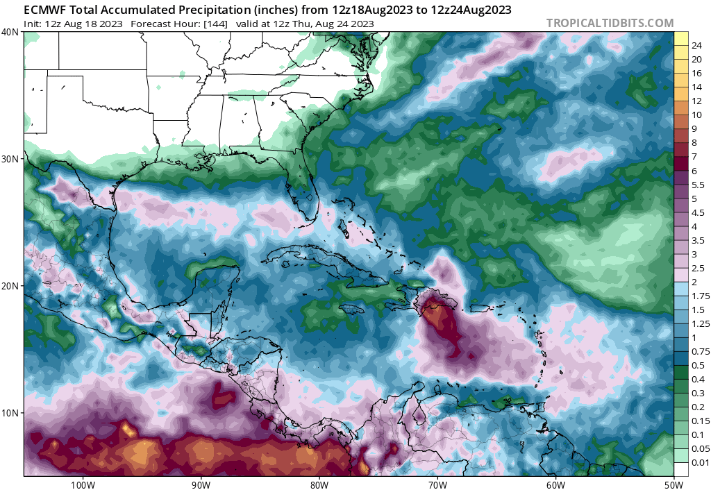
98L looks good on CIMSS MIMIC TPW. GFS suggests it doesn;t live long, but a name is possible. Shear and dry air as it heads NW. I'm interested in seeing if 99L can avoid development and get closer to the Caribbean. I want the Gulf lemon to develop, but models besides Euro, and even op Euro is meh, don't close a depression. GFS rainfall amounts from the wave are not impressive at all. Under half an inch. Euro's wave is generally an inch. Only a couple of GFS ensembles close a low. 20% probs are too high, for what will be an underwhelming wave with not that much rainfall. El Nino shear is coming, only a small window for anything before everything becomes unfavorable. LC's 11/4/1 seems like a good call. -
2023 Atlantic Hurricane season
Ed, snow and hurricane fan replied to Stormchaserchuck1's topic in Tropical Headquarters
98L per SHIPS is a hurricane in 3 days before 35 knot shear starts to destroy it. -
Central & Eastern Pacific Thread
Ed, snow and hurricane fan replied to Windspeed's topic in Tropical Headquarters
NHC forecast has it as non-tropical, but I haven't given up hope Hilary will not be declared post tropical before California. -
2023 Atlantic Hurricane season
Ed, snow and hurricane fan replied to Stormchaserchuck1's topic in Tropical Headquarters
12Z GFS almost closed the wave in the Gulf, the 18Z was a little further off. Only a couple of the 18Z GEFS close a low. 12Z Canadian very weak low near the border is worst case scenario with 18 straight 100°F days in Houston and 7 weeks no rain. 18Z GFS wave does drop a widespread inch of rain. Not enough to stop the inevitable fires a week or two later. I think the big show this week is whether NHC will declare Hilary non-tropical before California. Forecast shows that, but I'm hoping. The wave near the CVs 'has the look' on MIMIC-TPW, even if it satellite presentation doesn't look that great. -
100°F today as a high, the high yesterday was 105°F, or we are cooler. 18Z GFS averages about an inch in SETX with the tropical wave. Doesn't look like any 18Z GFS ensembles close a low with that wave.
-
2023 Atlantic Hurricane season
Ed, snow and hurricane fan replied to Stormchaserchuck1's topic in Tropical Headquarters
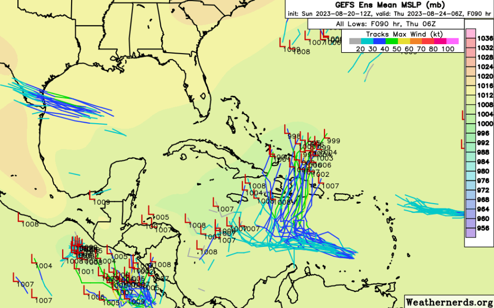
5 of the 18Z GFS ensemble members have very weak systems in the Gulf in the next week. This is mostly a Euro family thing, and Euro seems to have been tweaking. I think NHC could have waited a day or two to see if model support increased. Speaking of tweaking, the GFS ensembles in 12 days... -
As sometimes happens when depending on a tropical wave 10 days in the future, the op Euro cancelled the rain. EDIT TO ADD: There is a lemon in the Gulf, apparently based only on Euro ensembles, as only 5 GFS ensemble members have anything, all weaker than 1000 mb.
-
2023 Atlantic Hurricane season
Ed, snow and hurricane fan replied to Stormchaserchuck1's topic in Tropical Headquarters
HRD scientist doesn't seem to buy the development approaching 60W in 6 days on the ensembles. Nor does NHC, apparently. -
2023 Atlantic Hurricane season
Ed, snow and hurricane fan replied to Stormchaserchuck1's topic in Tropical Headquarters
Ballpark 60% of the ensembles at this time have a TC in the Gulf or off SEUSA, looks like about 40% of Euro ensembles have a one. 18Z Euro ensembles, about half of the members have the first wave off Africa as a TC next Saturday, with the weaker members entering the Caribbean, the stronger passing N of the Caribbean. Or, I say a coin flip we have at least one TC by early next week. If Euro ensembles are correct, NHC's lemon bubble may be oriented to much from SSE to NNW, when the ensembles are closer to E to W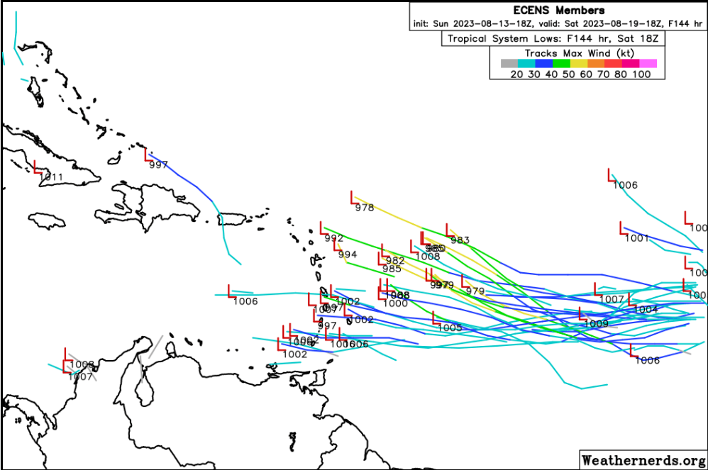
-
2023 Atlantic Hurricane season
Ed, snow and hurricane fan replied to Stormchaserchuck1's topic in Tropical Headquarters
As a rule, play by play at hour 300 on the GFS isn't probably needed. If those are still here in ten days, model run play by play, New England forum snowstorm style where people note the 200 mb jet streak over Minnesota is deeper than the prior run, that is coo..