

Ed, snow and hurricane fan
-
Posts
2,133 -
Joined
-
Last visited
Content Type
Profiles
Blogs
Forums
American Weather
Media Demo
Store
Gallery
Everything posted by Ed, snow and hurricane fan
-

El Nino 2023-2024
Ed, snow and hurricane fan replied to George001's topic in Weather Forecasting and Discussion
Living in Texas the last 40 years, Houston area the last 23, the idea of a Texas perma-drought being a whoops is not correct. It has definitely been dryer since 2011, even with events like the 2017 floods. -
Severe Threats: Winter 2023-2024
Ed, snow and hurricane fan replied to Chinook's topic in Central/Western States
It is starting. https://radar.weather.gov/station/KPOE/standard -
Severe Threats: Winter 2023-2024
Ed, snow and hurricane fan replied to Chinook's topic in Central/Western States
Suggestion in SWODY 1 of a possible Moderate later today. -
2023 Atlantic Hurricane season
Ed, snow and hurricane fan replied to Stormchaserchuck1's topic in Tropical Headquarters
NHC was up to a cherry, it is now back to an orange. -
2023 Atlantic Hurricane season
Ed, snow and hurricane fan replied to Stormchaserchuck1's topic in Tropical Headquarters
Latest 12Z GFS phase forecast via FSU web site is cold core. Highs here forecast in the low 60s Monday, I had thought of it earlier looking at the models as the Texas version of a Nor'Easter, just at least a month too early for snow. I imagine the 1895 storm resembled it. NHC lemon seems mostly driven by the GFS and family, but it has a few Euro ensemble members that develop a TC strength system. https://www.khou.com/article/news/by-the-numbers-houstons-history-of-snow/285-d9b65f7a-f789-42f0-9ca8-50ff6ce16455#:~:text=But as hard as it,in the history of Houston. -
0Z Friday PWAT on 12Z GFS AOA 2 inches along the coast ahead of the front. Even DFW approaches. (TT regional views don't have PWAT, tropical views do, looking at WATL) 5 inch Thursday into Friday bulleye near Victoria. Nice rain forecast along the Texas coast, near or below an inch up in DFW. Drought is sneaking back.
-
Cold front is a day early per Thursday/Friday forecasts and about 6 hours early per last nights forecast. Only a couple of hours away from Houston and it was forecast last night for the evening. Noon CDT/11MDT map.
-
El Nino 2023-2024
Ed, snow and hurricane fan replied to George001's topic in Weather Forecasting and Discussion
Related phenomena, late October I notice the sun setting just after 6 pm (we are W of the center of CDT) and then suddenly in November I am driving home in the dark. Must be related to the retreat of the subtropical ridge into Mexico. Speaking of La Nina type cold, near 90F today, but cold front w/ clouds and rain tonight that last until Wednesday, then a night below 40F in Houston and freezing N suburbs, if that was January I think we'd be having another winter 2020-21 and 22-23 pipe bursting lower 20s or even teens night. They don't bury pipes deep or insulate them well, but usually every 15 or 20 years, a pipe bursting palm tree stressing/killing freeze, although HOU has had 3 of them since 2009-2010 winter. Edit to Add Noon CDT (MDT in W Texas temp map. Mountains protecting El Paso from the front) It is hard, but you can see the front if you look closely.. -
El Nino 2023-2024
Ed, snow and hurricane fan replied to George001's topic in Weather Forecasting and Discussion
I'm not going to look at Bastardi's tweet history, but he just re-tweeted someone saying Modoki. I sort of know what a Modoki is, sort of, I assume it would mean a winter with 4 or 5 foot plus snow storms from DC and points North? Because that is what JB lives for. But my El Nino interest is about whether pipe bursting freezes (20F or below) are coming to Houston, most common with La Ninas although overall cooler winters w/ higher snow chances are El Nino. I don't know the PDO/AO type intricacies beyond that IMBY. My palms get very stressed, but can survive temps to 15F and day plus sub-freezing, which happened in 2 or the last 3 La Nina years. -
Central & Eastern Pacific Thread
Ed, snow and hurricane fan replied to Windspeed's topic in Tropical Headquarters
Watching YouTube and discovered there is a Fox Weather Channel, and Bryan Norcross works there. Besides the small nature of the storm and divergent pattern (in some ways a repeat of Ian, what was expected to weaken the system initially strengthened it) abnormally warm SST near-shore was explicitly mentioned as a factor in RI. I do wonder if Florida high rise building codes are followed in Acapulco. -
No recon tomorrow or Tuesday.
-
A storm forming E of the Caribbean in the second half of October is something. Possible threat to the N Lesser Antilles. NHC forecast predicts interaction with the islands. NHC is a bit W of most of the guidance, but I'm guessing they would rather low watches than raise watches on short notice.
-
Although Canadian and GFS favors the really good (3 inch plus) rains along and generally W of I-35, half an inch to an inch here next week will be welcome.
-
2023 Atlantic Hurricane season
Ed, snow and hurricane fan replied to Stormchaserchuck1's topic in Tropical Headquarters
NHC morning TWOAT suggests a PTC may be coming as soon as this afternoon for TS watches in the N Lesser Antilles. New GFS passes close enough to the St Martin and US and British VI for TS conditions Saturday. Candian sees a weak wave moving W which starts to develop as it moves N out of the Caribbean. NOAA tail doppler mission tomorrow morning. -
2023 Atlantic Hurricane season
Ed, snow and hurricane fan replied to Stormchaserchuck1's topic in Tropical Headquarters
The Guadeloupe hurricane not well supported by other guidance, but the most interesting scenario.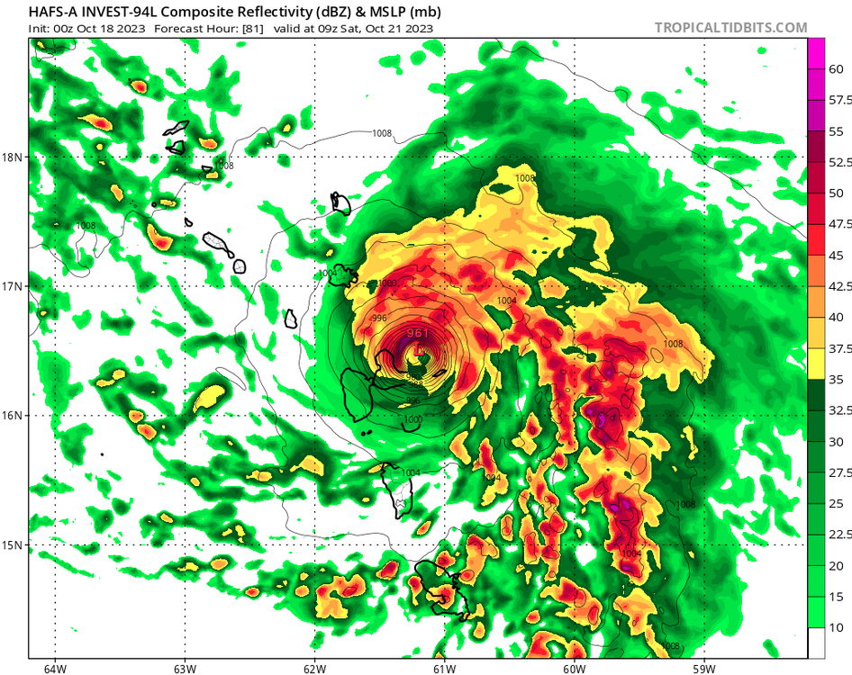
-
2023 Atlantic Hurricane season
Ed, snow and hurricane fan replied to Stormchaserchuck1's topic in Tropical Headquarters
Back from a 2 lemon to a cherry again. Still looks kind of 'meh'. -
2023 Atlantic Hurricane season
Ed, snow and hurricane fan replied to Stormchaserchuck1's topic in Tropical Headquarters
NHC dropped 2 day odds to 60%. I see a low to mid level circulation 8.5N 36W. ASCAT pass from 7 hours ago suggested no well organized surface low (although winds are generally cyclonic) and not very strong (15 to 20 knot max) winds near there. Most deep convection NW of where I see the spin. 6Z GFS gets it to Puerto Rico because it is so week it gets turned back to the SW. Euro ensembles show that, the members that threaten the islands are weak. SHIPS gets it to a hurricane, but stronger shear after 3 days forecast to keep it to a Cat 1 -
2023 Atlantic Hurricane season
Ed, snow and hurricane fan replied to Stormchaserchuck1's topic in Tropical Headquarters
I'm leaning out to sea for this, just a feeling, but the Euro ensemble mean is awfully close. Lot of 100+ knot storms in there as well -
2023 Atlantic Hurricane season
Ed, snow and hurricane fan replied to Stormchaserchuck1's topic in Tropical Headquarters
CV lemon mid October. 7 days cone of development looks like an August CV lemon. -
Central & Eastern Pacific Thread
Ed, snow and hurricane fan replied to Windspeed's topic in Tropical Headquarters
29 years ago the mid level circulation of Hurricane Rosa survived the Sierra Madre and set the San Jacinto river on fire. Rosa was a major, of course, maybe it is just weenieism, but I think it is at least a hurricane at landfall in the Baja
-
SETX doesn't have anywhere near as much severe weather in the Spring as NTX or STX because the NW Gulf is usually quite cool and more humid air from further in the Gulf on SE winds saturates and forms fog/low clouds which usually don't break until afternoon, which in combination with the EML on low-mid levels on SW flow off the higher elevations of Mexico means a cap that isn't broken the S part of the I-45 corridor. This year there wasn't much severe down here, but it wasn't because of cold shelf waters. Next year M-A-M, if the NW Gulf is again warm, might have the type of severe weather common in much of the rest of Texas.
-
2023 Atlantic Hurricane season
Ed, snow and hurricane fan replied to Stormchaserchuck1's topic in Tropical Headquarters
Morning HGX discussion mentioned Pacific system, shredded crossing the Sierra Madre, possibly developing into a hybrid low in the Gulf. Sensible weather for Texas little to none, but I could see a Florida rainstorm in a week. (1000 mb/40 knot STS type rainstorm) -
Expected light show driving N on TX 249. None. Full bore thunderstorm, minus the thunder, winds probably gusting near 40 mph moving my car around, blinding rain. No thunder at all with the heavy rain. There was thunder with the light rain afterwards.
-
Nothing severe, but decent MCS an hour from Houston, morning commute will be interesting.


