Ed, snow and hurricane fan
-
Posts
2,133 -
Joined
-
Last visited
Content Type
Profiles
Blogs
Forums
American Weather
Media Demo
Store
Gallery
Everything posted by Ed, snow and hurricane fan
-

Texas 2024 Discussion/Observations
Ed, snow and hurricane fan replied to Stx_Thunder's topic in Central/Western States
The effective front is passing Waco, storms are developing. Tornado warned storms in the Hill Country, radar indicated. Would reach I-35 around sunset, waiting to see if the supercells grow upscale, meaning my part of Texas sees weather tonight. -
Texas 2024 Discussion/Observations
Ed, snow and hurricane fan replied to Stx_Thunder's topic in Central/Western States
Near 70F dewpoints should be enough for a tornado or two in the Metroplex, even on the N side of the boundary although low level shear is near non-existent. I'm guessing the cell E of Abilene is riding the boundary or just N of it. -
Texas 2024 Discussion/Observations
Ed, snow and hurricane fan replied to Stx_Thunder's topic in Central/Western States
Hard to tell from the haze, but local (IAH, HOU, SGR) airports reporting cumulonimbus or thunder and there are a few cells around on radar. I Nor did HGX morning discussion) didn't think anything would develop locally with the cap in place (15Z RAP sounding for 18Z shows a convective temp of 103F), we'd be looking for storms from Central Texas.. IAH is 88/76. 8.7C/Km 700-500 mb lapse rate on the model sounding. About North Texas, waiting to see when storms develop on the warm side of the boundary. Which is past DFW proper. -
Looking busy on the projections so far. I'm staying on the conservative side of the entries so far.. 18 NS/10 H/4 MH.
-
Texas 2024 Discussion/Observations
Ed, snow and hurricane fan replied to Stx_Thunder's topic in Central/Western States
12Z HRRR moves a nasty looking cell right through DFW late afternoon, >4000 J/Kg MLCAPE and 50 knot shear. I'm calling a hail storm watch. -
2024 Atlantic Hurricane Season
Ed, snow and hurricane fan replied to Stormchaserchuck1's topic in Tropical Headquarters
From other thread, does the ONI/RONI strength hint at some protection for the US despite a forecast active season? -
Texas 2024 Discussion/Observations
Ed, snow and hurricane fan replied to Stx_Thunder's topic in Central/Western States
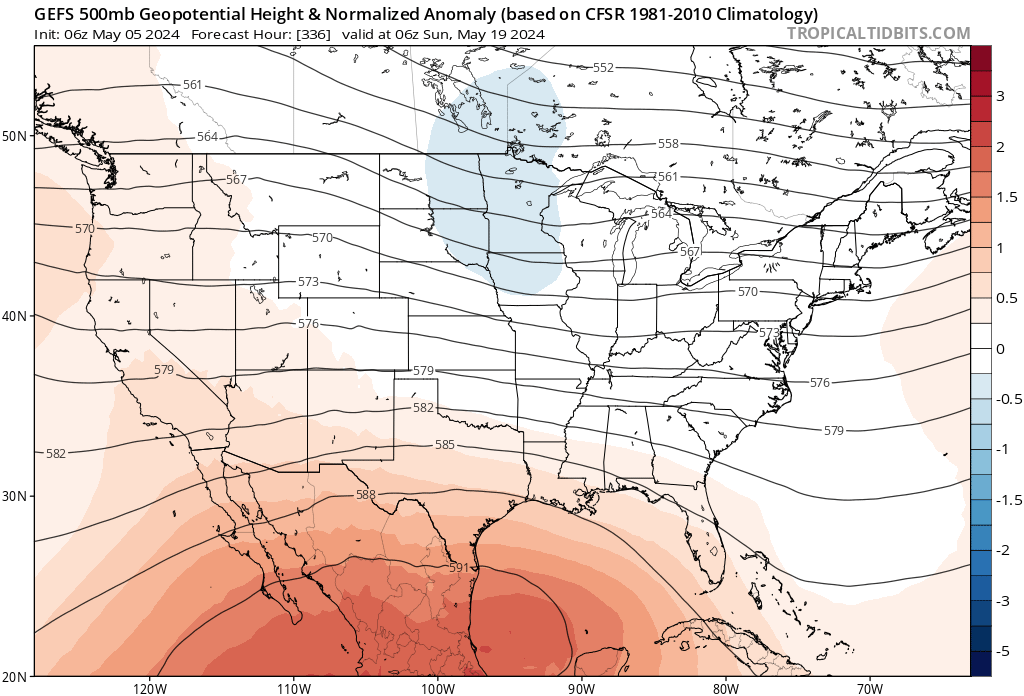
Rain has stopped and the clouds are breaking. Almost full sun in Houston area. I think we get by with only scattered storms the rest of today. Mid week, GFS shows >100F temps along the river where the 10% hatched hail is today. Summer may start a couple of weeks before meteorological summer per GEFS.
-
Severe Weather 5-6 through 5-9-24
Ed, snow and hurricane fan replied to cheese007's topic in Central/Western States
I hadn't read the ICT discussion but this showed up on X -
Severe Weather 5-3 and 5-4-24
Ed, snow and hurricane fan replied to cheese007's topic in Central/Western States
The twitter/X people who had Fort Stockton trending (at least for me) were correct. Timmer had it, now he is on a big rain shaft with a new wall cloud forming. -
Severe Weather 5-3 and 5-4-24
Ed, snow and hurricane fan replied to cheese007's topic in Central/Western States
First watch of the day, N of the front. SPC meso says Tornado Watch S of the front likely later this afternoon. https://www.spc.noaa.gov/products/watch/ww0183.html https://www.spc.noaa.gov/products/md/md0629.html -
Texas 2024 Discussion/Observations
Ed, snow and hurricane fan replied to Stx_Thunder's topic in Central/Western States
I'm not sure whether 'Future Cast' is a private model, but Thursday night, both KPRC and KHOU used it, and it predicted the heavy rain Friday afternoon, not early morning Friday. Getting to work in Tomball was hairy. Nowhere near as much rain fell in Spring (I'm in the Spring ISD with a Houston mailing address). The heavy rain fell in almost the same places. HRRR 12Z is more rain just E of the worst impacted areas, and a lot of it, other models are drier. River flood statements have dates of comparable floods, late August/early September 2017 (Hurricane Harvey) and October 1994 (flooding from remnants of Pacific Hurricane Rosa) are showing up. -
Texas 2024 Discussion/Observations
Ed, snow and hurricane fan replied to Stx_Thunder's topic in Central/Western States
It rained a lot at work near DWH
-
Severe Weather 4-30-24 through 5-2-24
Ed, snow and hurricane fan replied to cstrunk's topic in Central/Western States
Severe Weather Statement National Weather Service Norman OK 839 PM CDT Tue Apr 30 2024 OKC015-031-010200- /O.CON.KOUN.TO.W.0084.000000T0000Z-240501T0200Z/ Comanche OK-Caddo OK- 839 PM CDT Tue Apr 30 2024 ...A TORNADO WARNING REMAINS IN EFFECT UNTIL 900 PM CDT FOR NORTH CENTRAL COMANCHE AND SOUTHWESTERN CADDO COUNTIES... At 837 PM CDT, a confirmed tornado was located near Boone, moving north at 10 mph. HAZARD...Damaging tornado and half dollar size hail. SOURCE...Weather spotters reported a tornado south of Boone, moving north. IMPACT...Flying debris will be dangerous to those caught without shelter. Mobile homes will be damaged or destroyed. Damage to roofs, windows, and vehicles will occur. Tree damage is likely. Locations impacted include... Apache, Boone, northwestern Lake Ellsworth, and Stecker. -
Severe Weather 4-30-24 through 5-2-24
Ed, snow and hurricane fan replied to cstrunk's topic in Central/Western States
I think 'SLIGHT' gets extended towards Wichita Falls if SPC buys the 3km NAM. A lot of activity on the dry line. Weak winds on forecast skew-T but near 4000 J/Kg MLCAPE suggests hail threat. Not super exciting shear. Line weakens after dark. FV3 looks similar, maybe a bit less coverage. -
Severe Weather 4-25 through 4-28-24
Ed, snow and hurricane fan replied to cheese007's topic in Central/Western States
Chickens, goats and a funnel cloud. Didn't see dust on the ground. -
2024 Atlantic Hurricane Season
Ed, snow and hurricane fan replied to Stormchaserchuck1's topic in Tropical Headquarters
I've been wondering about your ONI/US landfall correlation in prior cold ENSO seasons. Far above normal NS but below normal US impacts, something most people would like. I'm sensing another strong STR for Texas, and an early season TS/Cat 1 with some decent rain before the oven kicks on wouldn't bother me. -
Severe Weather 4-25 through 4-28-24
Ed, snow and hurricane fan replied to cheese007's topic in Central/Western States
Benefit of Twitter- I don't have the attachment space, but... -
Severe Weather 4-25 through 4-28-24
Ed, snow and hurricane fan replied to cheese007's topic in Central/Western States
-
Severe Weather 4-25 through 4-28-24
Ed, snow and hurricane fan replied to cheese007's topic in Central/Western States
Radar indicated BULLETIN - EAS ACTIVATION REQUESTED Tornado Warning National Weather Service Fort Worth TX 256 PM CDT Sun Apr 28 2024 The National Weather Service in Fort Worth has issued a * Tornado Warning for... Southwestern Freestone County in central Texas... Southeastern Limestone County in central Texas... * Until 345 PM CDT. * At 256 PM CDT, a severe thunderstorm capable of producing a tornado was located near Lake Limestone, or 7 miles southeast of Groesbeck, moving northeast at 35 mph. -
Severe Weather 4-25 through 4-28-24
Ed, snow and hurricane fan replied to cheese007's topic in Central/Western States
Tornado risk in I-35 boundary from near the border to just S of Waco and then curving NE. Lower dewpoints N of the boundary but high enough to support a tornado if a supercell can form and follow the boundary? The4 circled area is essentially the ENH area. -
Texas 2024 Discussion/Observations
Ed, snow and hurricane fan replied to Stx_Thunder's topic in Central/Western States
Unfortunately I try to sleep at 1 am, but 12Z HRRR finally gets thunderstorms in Houston, with near 2500 J/Kg MLCape (after midnight!) and 40 knots effective shear. Enhanced Severe on 1300 SWODY1 gets as close to Houston as San Jacinto County. @Stx_Thunderhas access to t-storm probability maps. This begins the time of year when the Corpus Christi 12Z sounding has 4500 J/Kg surface cape but a 99F convective T. Amazing values of CAPE that will not be tapped by storms. -
Severe Weather 4-25 through 4-28-24
Ed, snow and hurricane fan replied to cheese007's topic in Central/Western States
I spent weeks at a time living out of a small apartment (it has satellite TV) above the shop in Kamay, TX when we were drilling wells. Kamay is in SW Wichita County about an hour away from possible impact. I thought back when this storm was approaching Knox City it would easily pass W as it headed into Oklahoma, but it made a sharp right turn before Knox City. I had thought if the storm produced a tornado it would have passed N of Knox City, in fact. I can't tell what Nick Busby on RHY'A is looking at. -
Severe Weather 4-25 through 4-28-24
Ed, snow and hurricane fan replied to cheese007's topic in Central/Western States
Confirmed tornadoes, but I haven't seen any chaser footage yet. NW of Stillwater storm may be the first. I'd have hoped someone would have tried to chase tail end charlies down near where the Knox City storm is. -
Severe Weather 4-25 through 4-28-24
Ed, snow and hurricane fan replied to cheese007's topic in Central/Western States
Confirmed tornado Grant and Garfield cos. OK. Time to see if Ryan Hall is livestreaming chasers. I've haven't seen so many truly scary tornadoes livestreamed since 2013. -
Severe Weather 4-25 through 4-28-24
Ed, snow and hurricane fan replied to cheese007's topic in Central/Western States
MCD mentions possible PDS watched by 18Z.