

jdj5211
-
Posts
209 -
Joined
-
Last visited
Content Type
Profiles
Blogs
Forums
American Weather
Media Demo
Store
Gallery
Everything posted by jdj5211
-
practically in the same spot as 18Z run at HR30....just a tad weaker...
-
One important thing to point out is that this storm has consistently been on the southwest side of pretty much all guidance. It's one thing to follow model trends but actual observations are just as, if not more important! I don't think NYC/NJ is out of the woods yet by any means. Keep an eye on the movement of Henri over the next 12-24 hours....
-
0z NAM running....have a gut this is going to be a monster run!
-
You think this is nice. Wait til you see the GFS!!!
-
large dendrites....nice
-
I saw this but can't see the timestamp on it...
-
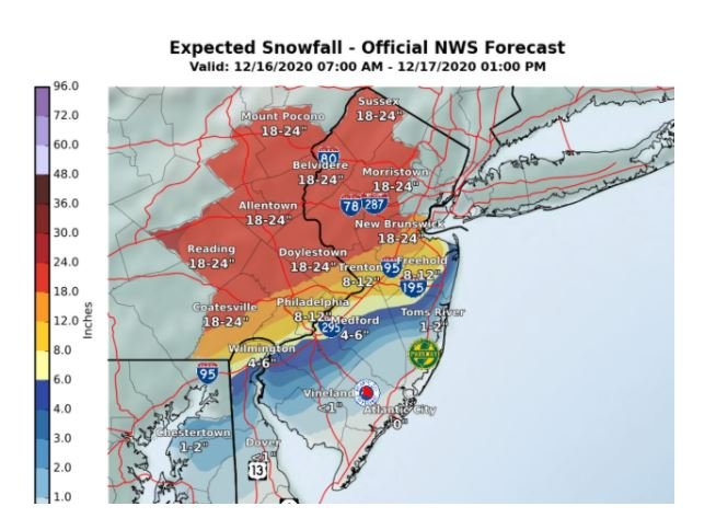
just saw an image from NWS...raised totals in NNJ to 18-24 inches....is that true?
-
we hit page 100! I truly hope this storm is at least worth all of this chatter! (kidding obviously, it's always worth it!)
-
I like to keep an eye on each run of the HRRR. First place you may start to catch trends and movement of precip....that last run looks good so far...
-
from HR 33- HR 36 the low jumps back west....doubt that happens....I like this run overall...much better than 12Z if it continued on the ENE track it would remain all snow NNJ/NYC HR 39 crashes back to all snow....that little hiccup west is likely incorrect
-
keep seeing that dry slot move in....not sure if it's real or not yet...
-
Wow....everyone needs to relax for a minute. This is ALL about the placement of the 850mb low. That’s it! That’s what’s causing the difference in the models. They’re simple trying to resolve that placement. Take a look at that precip shield on the NAM with the moisture plume coming out of the gulf about 12 hours before the storm gets to us! The cold air is in place, the block is in a good place. This is a monster storm for mid December. Unfortunately, it’s a nowcast situation as we watch the development. However, in my opinion this is an all snow event from PHI/NYC north and a mostly rain event for SNJ and the coast. The question is what happens in between? Where does that mixing line set up?
- 3,762 replies
-
- 3
-

-
- heavy snow
- heavy rain
- (and 3 more)
-
Not a fan of this euro run. That low is way too close to the coast
-
That run taken verbatim would absolutely dump more than 14-16 inches in NNJ for sure. With that QPF output and temp profile there’s no way it’s a 7 or 8-1 ratio. More like 10 or 12-1 which would support 20-24 inch amounts.
-
0Z EURO hasn't run yet....
-
So we're about 36 hours from the storm and we generally have no idea what's going to happen? And by that I mean, who is getting shafted, where the heaviest precip falls, is there a dry slot, is there a jackpot zone? Is that fair to say.....IMBY I've had anywhere from 6 inches to 29 inches the past 2 days of runs....
- 3,762 replies
-
- 1
-
-
- heavy snow
- heavy rain
- (and 3 more)
-
GFS kinda ugly... Philly gets 20 inches....while other models have major dry slot into Philly with a few inches....you can't make it up really...
-
I was going to say, I'm only out to to HR 42?!
-
I'm feeling fuzzy about this run.....
-
I agree that precip shield is odd...not sure what to think about this run as a whole
-
That high is no joke on the NAM. Also looks like a crazy snow hole over Philly and SNJ gets basically nothing
-
CMC running. Looks a tad SE so far. Was a monster run last night
-
Big hit on GFS...colder solution...not quite the CMC/RGEM/EURO but got closer
-
RGEM has been pretty consistent with that path and snowfall totals the last few runs....12Z GFS running now...important run
- 3,762 replies
-
- 1
-
-
- heavy snow
- heavy rain
- (and 3 more)