

jdj5211
-
Posts
209 -
Joined
-
Last visited
Content Type
Profiles
Blogs
Forums
American Weather
Media Demo
Store
Gallery
Everything posted by jdj5211
-
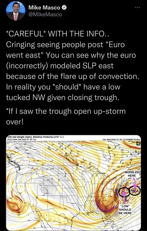
This is going to be a bit of a nowcast event like many of our big storms. Small shifts bring big differences. How many storms have we seen shift to monsters or nothing within 24 hours?! I still feel this is going to be a tucked in crawling if not stalling low that brings a widespread 12-24 to the entire sub forum. These models are chasing the rising motion under the eastern intense vorticity and causing this “eastward” thought, when in reality it’s not the case. In my opinion. GAME ON!
-
You see how the NAM had 2 lows and initially followed the eastern low but then at HR 54 it jumps back to the western low. If it followed that western low track this is a monster run for everyone. Especially those NW of NYC. Keep an eye on that! There’s so much deepening going on that it’s having a hard time figuring out the low position. This is where the 500mb track comes in and it looked good!
-
-
So basically overrunning lead snows start moving in Friday night and by Saturday morning there's 3-6 inches on the ground before the fun begins!
-
she's gunna blow!
-
One of my favorite things you've said and I consider you one of the more knowledgeable people in this forum! I haven't been this pumped up for a storm in a long time...probably since Boxing Day....
-
GFS rolling. Would love to have this one more towards the Euro camp….
-
This is going to be a nice run! Not as good as 12Z but better than the 18Z...came back west a bit and a deeper low
-
No real noticeable differences through HR 78... Precip looks a little more robust but that's surface map... Energy held back a little bit through HR 84....
-
GFS is off and running...one of the bigger runs of the season! The weenie in me is pumped!
-
I’ll take that 12z GFS run! Low rides the NJ coast at 987. Takes about a 6 hour trip from Cape May to NYC. Yes, still warm but a much better spot and still time to go! 6-12 inch amounts northern and nw NJ into PA on the clown maps.
-
can you say BOMB CYCLONE haha....drops 23hpa in 24 hours....
-
everyone patiently awaiting the 0z runs!
-
102 to 108 is the key there....phases, bombs and tracks NW...if that doesn't happen there it's a monster coastal....we're not far off but not there yet..... and 108 to 114 this thing crawls.....damn what could be!
-
Not only is the low further south, but I believe it shows a much stronger CAD wedge with the high in a more favorable position. Better chance for low level cold air at the surface. NAM always performs better on wedge events as we know, but usually within 36 hours so we'll see....
-
I put pretty much zero into the 84HR NAM lol but taking it verbatim it's not a bad run compared to previous...let's see what GFS and others have in store...0z tonight should start to paint a better picture IMO
-
12z GFS and Euro in pretty remarkable agreement with the low passing through central PA around the same timeframe. Going to take a big swing east or a transfer to the coast (not out of the question yet) for this not to be a mostly heavy rain storm. Any front end snow will be washed away anyway so who cares.
-
And another monster rain storm. QPF outputs should be very high. Just need this baby to track east
-
HR 102: High is noticeably northwest. Low is plotted closer to the coast.
-
Minor differences through 84 on GFS though the low is slightly further south and the high is slightly further north…would think this is going to be west again Then at HR 90 things change a bit!
-
That’s why it was disclaimed. It’s a simple post…you can choose to ignore and move on. We have people talking about absolute unrelated nonsense on here….at least it was related to the storm.
-
I give the NAM an occasional win every now and then and data is data
-
I know it’s the NAM but the 0z run is west with the hurricane heading for a Texas landfall….interesting to see if upcoming 0z GFS run heads in that direction as well….
-
same at HR 36....tad east but about the same strength as 18Z run.....basically an identical run as 18Z with a slight shift E....have to wait for GFS run...


