NotSureWeather
-
Posts
406 -
Joined
Content Type
Profiles
Blogs
Forums
American Weather
Media Demo
Store
Gallery
Everything posted by NotSureWeather
-
Think it’s either a depression or upgraded to potential at 2pm. I’m on my phone but the last few images you can really see it getting the pieces in place.
-
They get 3-5 every year versus 0-2 for this area. Which was the point of their post…
-
Bet there is a psychology student somewhere using this forum for their thesis on mental instability.
-
Basically every model has been trending east since yesterday.
-
Looks like it’s improved a bit the last couple hours or so.

-
GFS has been pretty consistent with where it’s putting the low off the Antilles. Think that’s where people should focus for now. It needs to get to a certain location for us to be in the crosshairs. Does seem like a shift east on the last few model runs though. It’s probably nothing, but at least we have something to complain about.
-
Based off the last 33 years this probably is nothing
-
Way too early to have any clue what will happen. Gonna be 4-5 days before we can start trusting the models a little.
-
Pretty good chance we see a cane before GTA 6 tho
-
A cat 3-4 in this area would be absolutely terrible. Mid tier cat 2 is the highest I would want. Never seen the hurricane dike closed in New Bedford but definitely would if that somehow happened.
-
Can the tropics support a train of storms like is being modeled? Or will it lower the SST low enough to inhibit them?
-
No I mean the circulation out in the Atlantic that’s looking better by the minute
-

Decrepid Debby/PRE - Flooding, Severe Threat
NotSureWeather replied to TalcottWx's topic in New England
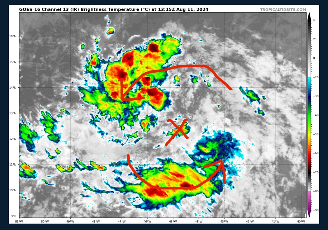
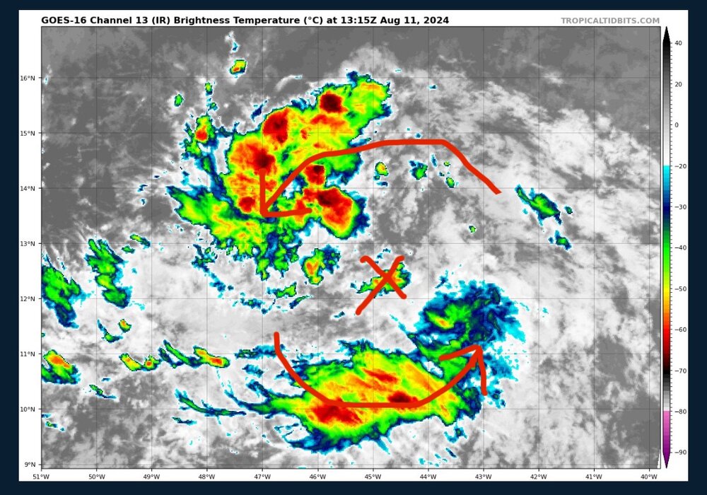
That circulation southeast of Debby a concern at all? It’s grown a decent amount the past few hours and almost seems like it’s tugging at Debby. Not saying Fujiwara but it kinda looks like it. -
That circulation southeast of Debby a concern at all? It’s grown a decent amount the past few hours and almost seems like it’s tugging at Debby. Not saying Fujiwara but it kinda looks like it.
-
You can also see convection has been blowing up in the NE quadrant for awhile now. The moisture has basically wrapped around just in time and I think it might of helped pull the system more east.
-
Stronger and more east
-
Waaaay earlier and way further south.
-
Been almost due east for 5 hours and the east side of the center is basically over the Atlantic already. Around 16 hours before the NHC track. They should be able revise whenever they want since they have looked pretty wrong for the last 5 hours.
-
Back over the Atlantic 16 hours early.
-
At some point do we acknowledge that this storm has been east of every forecast?
-
Think it's gonna make it over water just in time. Also looks like it did the whole tuck move as it wrapped moisture around. Which looks like that maybe contributed to the pretty significant jog east?
-
Since the 5 PM update it has moved almost due east and looks like its almost outside the NHC's cone.
-
It's moved almost due east since the 5 PM update. Its probably about 50 miles from the coast at this point. Its close enough already to starting pulling off the ocean. You can see bands popping up to the northeast, in the last few frames.
-
Not really true. If the center gets out into the Atlantic it will strengthen some potentially. Over land it will degrade and end up more west, most likely. Mostly just watching how east it makes it before heading north or west if the GFS somehow scores the upset.
-
Still goes basically due west after crossing into the Atlantic