

wizard021
-
Posts
413 -
Joined
-
Last visited
Content Type
Profiles
Blogs
Forums
American Weather
Media Demo
Store
Gallery
Everything posted by wizard021
-
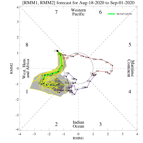
phase 8 to 1 is favorable. You get most hurricane in phases 8 to 2.
-
-
Wrong . Phase 8 to 1. Look at the chart .98l is moving into a rising atmosphere not sinking . Don't focus on tutt lows they come and go and can act to enhance outflow.
-
Dude get a clue there is always tutt lows . It is about how the systems interact with them. Mjo is phase soon.
-
This is a classic s florida strike pattern. Trough split, allowing ridge to build explosively . Ecmwf has a phantom trough recurve like with Ike it showed.
-
-
Gfs still makes landfall with future 98l in Brownsville with a cat 1?
-
Could be , but with the amplified mjo moving in, have to think conditions will be as favorable as the other non gfs models have it.
-
Ukmet is north , cmc is middle ground and gfs is furthest south. Gfs has been having wild swings on intensity from 00z to 06z to 12z.
-
https://tropicaltidbits.com/analysis/models/gem/2020081712/gem_shear_watl_29.png Light shear, mjo pulse, and warm waters will easily lead to a strengthening hurricane as depicted here. Gfs is tossed as of now.
-
Cmc/Ukmet both north of the islands and intensifying toward south florida or keys.
-
Based on the globals west path is likely, how far north initial movement tied to faster or slower formation. I am sticking with the Ukmet, likely north of islands and west track into florida as a cane.
-
Aew the further east one is trouble.
-
I think a west path is favored with a florida landfall most likely i.e andrew/ frances. But we shall see. Euro ensembles clustered near Florida.
-
NEW TROPICAL CYCLONE FORECAST TO DEVELOP AFTER 60 HOURS FORECAST POSITION AT T+ 60 : 14.3N 40.6W LEAD CENTRAL MAXIMUM WIND VERIFYING TIME TIME POSITION PRESSURE (MB) SPEED (KNOTS) -------------- ---- -------- ------------- ------------- 1200UTC 19.08.2020 60 14.3N 40.6W 1009 27 0000UTC 20.08.2020 72 16.2N 44.9W 1009 33 1200UTC 20.08.2020 84 16.9N 49.5W 1009 34 0000UTC 21.08.2020 96 17.5N 53.1W 1008 33 1200UTC 21.08.2020 108 18.0N 55.6W 1006 36 0000UTC 22.08.2020 120 18.9N 58.3W 1004 38 1200UTC 22.08.2020 132 19.5N 61.5W 1001 41 0000UTC 23.08.2020 144 20.1N 64.7W 998 47
-
African wave will be a big hurricane.
-
Ukmet develops the aew into hurricane
-
NEW TROPICAL CYCLONE FORECAST TO DEVELOP AFTER 138 HOURS FORECAST POSITION AT T+138 : 18.1N 84.3W LEAD CENTRAL MAXIMUM WIND VERIFYING TIME TIME POSITION PRESSURE (MB) SPEED (KNOTS) -------------- ---- -------- ------------- ------------- 1200UTC 22.08.2020 144 19.1N 85.2W 1006 26
-
NEW TROPICAL CYCLONE FORECAST TO DEVELOP AFTER 66 HOURS FORECAST POSITION AT T+ 66 : 13.5N 39.4W LEAD CENTRAL MAXIMUM WIND VERIFYING TIME TIME POSITION PRESSURE (MB) SPEED (KNOTS) -------------- ---- -------- ------------- ------------- 1200UTC 19.08.2020 72 14.5N 41.4W 1009 30 0000UTC 20.08.2020 84 15.8N 45.9W 1007 35 1200UTC 20.08.2020 96 16.5N 50.1W 1007 35 0000UTC 21.08.2020 108 17.5N 53.2W 1006 36 1200UTC 21.08.2020 120 18.8N 56.0W 1004 40 0000UTC 22.08.2020 132 19.4N 58.8W 1002 41 1200UTC 22.08.2020 144 20.2N 61.7W 1000 42
-
Ukmet develops both nhc areas .
-
Vrot on is 60 kt. Thats a ef3 + tornado offshore.


